Marysville dates to 1816, and 11% of its homes were built before 1940
More historic than 83% of U.S. towns · #260 of 993 in Ohio. What drives it
7 places in town are on the National Register, among them two historic districts with 91 buildings between them. Below: 10 old photos and papers, maps from 1885 on, and the census since 1840.
Founding year: Wikidata. First post office: 1823.The full story ↓
History grade
What drives Marysville’s History grade
On its age, its old homes and the National Register, Marysville is more historic than 83% of U.S. towns, #260 of 993 in Ohio. All 3 inputs are above most U.S. towns; its National Register listings ranks highest and its share of homes from before 1940 lowest.
A−
HistoryA character grade: shown, never part of Marysville’s overall grade.
Ohio towns list about as much on the Register as the country (a typical Ohio town has 2.9 per 10,000 residents, the U.S. 2.4), so Marysville’s 34.9 sits above most of its state (86% of Ohio towns have fewer) while its 96 historic buildings outnumber those of 89% of U.S. towns.
How sure. Graded on any two of the three inputs instead, the letter would range from B+ to A. The pre-1940 share (±2.6 points) is firm at this size. Two sources give 1816.
Founding year: Wikidata (other dates in Quick answers). Homes: Census ACS 2020–24. National Register: National Park Service, May 2026 list; each listing counted once (boundary changes and added documentation belong to their listing), and a historic district counts its contributing buildings. How TownRatings grades history →
What stands out about Marysville’s past
Read from the archive, the National Register and the record. The page puts what stands out first.
National Park Service, National Register of Historic Places. Photos from Wikimedia Commons, credited on each place’s page.
Places that used to be
Old corners and burying grounds
Old hamlets and crossroads still carry their names on the map.
Hamlets and corners on the map
Adena PointeAshton MeadowsCarriage AcresCountryside Mobile Home ParkDippleFleetwood ParkGreen PasturesGreenwood ColonyHickory RunHillcrest Mobile Home ParkMarysville EstatesMilford EstatesMillcreek Meadows
2cemeteries and burying grounds inside Marysville
OakdaleSaint Johns
US Post Offices dataset (Blevins & Helbock, CC0). Places and cemeteries from the USGS Geographic Names Information System (2021).
Every building
Marysville, building by building, 1885–1916
Fire insurance maps drew every building, what it was made of and what it was used for, so insurers could price the risk of fire. Pick a year, then a sheet.
Marysville was originally part of Northwest Territory, and then became part of the Virginia Military District within that territory, and eventually became part of the state of Ohio. One of the original surveyors of the area was James Galloway, Jr., who first visited in 1805. Marysville was founded in 1819 by Samuel W. Culbertson, who named the town after his daughter Mary, along the small waterway of Mill Creek.
nothing upon the records to show such was the case. Mention of Marysville as the county seat, on the pages of the court record, is found under date of May 15, 1821, when it was "ordered that David Comer be paid one dollar and fifty cents per day as director of the town of Marysville. the seat of justice of this county." Mr. Comer had been appointed to the position of director on the loth of July, 1820. Matters concerning the sale of lots, etc., will be found in the historical sketch of Marysville in this volume.
Text read by machine from the scan; it may contain errors.
The History of Union County, Ohio, containing a history of the county1883 · page 315Read the page →
Read the text
These Commissioners were required to make their report to the " next Court of Common Pleas" for Union County, and doubtless did so, but there is nothing upon the records to show such was the case. Mention of Marysville as the county seat, on the pages of the court record, is found under date of May 15, 1821, when it was " ordered that David Comer be paid SI. 50 per day as Director of the town of Marysville, the sent of justice of this county." Mr.
Text read by machine from the scan; it may contain errors.
ninety-six years ago. Union was then included in Delaware county, and a transcript from the records of the last named county shows the following description of the place : "Plat of the town of Marysville, which is situated on Mill creek, a branch (if the West fork of the Scioto river, in Delaware county, Ohio, which was surveyed and laid out, agreeable to the above plat, for Samuel W. Culbertson [the initial letter "W" was possibly by oversight, left out] Esq., proprietor of said town, as laid out to the cardinal points of the com-
Text read by machine from the scan; it may contain errors.
The History of Union County, Ohio, containing a history of the county1883Read the page →
Read the text
Marysville having been fixed upon as the seat of justice for the county of Union, David Comer was, on the 10th of Jul}', 1820, appointed Director of said town, with Thomas McDonald and George Harris as his bondsmen. On the day following it was " Ordered bi/ the Court, That David Comer, the Director of the town of Marysville, be governed in his proceedings by the following rules, to-wit : That he select the grounds and lots ; that he receive deeds for the county ; that he sell the lots at public sale, giving first thirty days' notice in the neighboring papers ; that he sell for one-tenth in hand and the iDalance in four equal annual
Text read by machine from the scan; it may contain errors.
Scans and text from the Internet Archive. Books published in 1930 or earlier, which are in the public domain.
Timeline
Marysville, 1816 to 1980
Woven from the archive, old maps, post office records, the National Register and the people born here.
Nothing in the archives for these yearsWeddings on Main Street, storms, parades, school pictures, the old store. If it’s in your family album, it belongs here.
In 1816, according to Wikidata. Marysville’s post office opened in 1823, and the census of 1840 counted 360 people here.
How does Marysville rank for history?
Marysville is more historic than 83% of U.S. towns, #260 of 993 in Ohio. The History grade combines the town’s founding era, the share of homes built before 1940 and its National Register listings. It’s a character grade, so it isn’t part of the overall grade. How it works.
What is on the National Register in Marysville?
7 listings: 5 buildings, among them the Gilcrist House (listed 1976, the first), and 2 historic districts, the Marysville Historic District and the Oakdale Cemetery Historic District, with 91 contributing buildings. 96 historic buildings in all.
How old are the homes in Marysville?
11% of Marysville’s homes were built before 1940 (Census estimate, ±2.6 points), against a typical 15% for an Ohio town; the median home was built in 1999.
Founding dates: Wikidata, Wikipedia, the U.S. post office records of Blevins & Helbock (CC0) and the Census. Homes by year built: Census ACS 2020–24. National Register of Historic Places: National Park Service (list of May 22, 2026). Old photos, postcards and papers: Wikimedia Commons, the Library of Congress and other public archives, credited on each item’s page. Maps: U.S. Geological Survey historical topographic maps (via Esri) and Sanborn fire-insurance maps (Library of Congress). History text and census tables: Wikipedia (CC BY-SA 4.0). Places that used to be: USGS Geographic Names Information System (2021).
From Wikimedia Commons (17), Wikidata (1), the National Register of Historic Places (7), Wikipedia, Wikidata and Wikipedia for famous people, U.S. Geological Survey historical maps, U.S. Census counts (via Wikipedia), the US Post Offices dataset (Blevins & Helbock), the USGS Geographic Names Information System, Sanborn fire insurance maps (Library of Congress) and old county and town histories (Internet Archive). Archive images are copied here with their credits and licenses, shown on each photo’s page. Refreshed monthly.


 1908
 1909
 1909
 1909
 1909
 1910
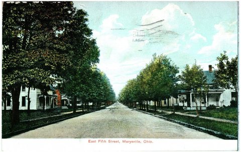 1912
 1912
 2012
 2009
 2009
 2009
 2009
 2009
 2007


