Marietta dates to 1788, and 42% of its homes were built before 1940
More historic than 98% of U.S. towns · #11 of 993 in Ohio. What drives it
14 places in town are on the National Register, among them the W.P. SNYDER, JR. (steamboat), a National Historic Landmark, and three historic districts with 2,301 buildings between them. 14 places in town are on the National Register, among them the W.P. SNYDER, JR. (steamboat), a National Historic Landmark, and three historic districts with 2,301 buildings between them. Below: 2 old photos and papers, maps from 1900 on, and the census since 1800.
Founding year: Wikidata. First post office: 1794.The full story ↓
History grade
What drives Marietta’s History grade
On its age, its old homes and the National Register, Marietta is more historic than 98% of U.S. towns, #11 of 993 in Ohio. All 3 inputs are above most U.S. towns; its National Register listings ranks highest and its age lowest.
A+
HistoryA character grade: shown, never part of Marietta’s overall grade.
Ohio towns list about as much on the Register as the country (a typical Ohio town has 2.9 per 10,000 residents, the U.S. 2.4), so Marietta’s 1,750 sits above most of its state (100% of Ohio towns have fewer) while its 2,310 historic buildings outnumber those of 99% of U.S. towns.
NoteThe founding year comes from Wikidata alone; no second source gives 1788.
How sure. Graded on any two of the three inputs instead, the letter would range from A to A+. The pre-1940 share is a Census survey estimate (±3.6 points).
Founding year: Wikidata (other dates in Quick answers). Homes: Census ACS 2020–24. National Register: National Park Service, May 2026 list; each listing counted once (boundary changes and added documentation belong to their listing), and a historic district counts its contributing buildings. How TownRatings grades history →
What stands out about Marietta’s past
Read from the archive, the National Register and the record. The page puts what stands out first.
The country’s official list of buildings and places worth saving. One is a National Historic Landmark, the highest tier. Boundary changes and added documentation are counted with their listing.
Succeeding Indigenous cultures lived along the Ohio River and its tributaries for thousands of years. Among them were more than one culture who built earthwork mounds, monuments which generally expressed their cosmology, often with links to astronomical events.
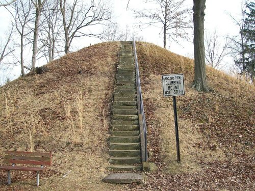
Between 100 BC and AD 500, the Hopewell culture built the multi-earthwork complex on the terrace east of the Muskingum River near its mouth with the Ohio. It is now known as the Marietta Earthworks. Developed over many years, it had a large enclosed square, within which were four platform mounds, used for ceremonial purposes and elite residential; another square, and a larger conical mound used for burials. A walled, graded path led to the river's edge.
It has already been stated that the township of Marietta was established by the court of quarter sessions in 1790;^ but Marietta was not incorporated as a town until the year 1800. Until the year 1825, the incorporated town and the township of Marietta appear to have been coextensive. On September 1, 1800, was taken the first stej) toward the incorporation of the town, when a meeting of the citizens was held for that x>urpose. At that meeting a committee, con-
Text read by machine from the scan; it may contain errors.
The incorporation act was framed after those enacted in Massachusetts. The first section of the act to incorj)orate the town of Marietta sets forth the boundary of the land known by the name of the town of Marietta, to-wit: "beginning at a post on the northern bank of the Ohio river, at a point where the line between the seventh and eighth ranges of townships, surveyed agreeable to the ordinance of Congress of the twentieth of May, one thousand seven
Text read by machine from the scan; it may contain errors.
A genealogical memoir of the Backus family, with the private journal of James Backus, together with his correspondence bearing on the first settlement of Ohio, at Marietta, in 1788. Also, papers and correspondence of Elijah Backus, showing the character a1889Read the page →
Read the text
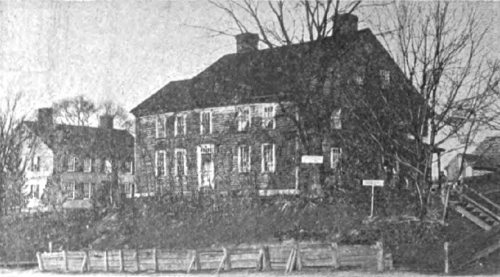
he was one of the Puritan stock of the first settlers of New England ; he built the first frame house in the new settlement. The first yoke of oxen from New England that trod the sod of Marietta were driven from Connecticut, and belonged to him. The first saw mill crank and saw mill saw were made by his father, and the first grist mill si)indle, plow iron and other irons, were made at the same place. Backus Iron Works, Norwich. James Backus had means and resources of his own, and
Text read by machine from the scan; it may contain errors.
A genealogical memoir of the Backus family, with the private journal of James Backus, together with his correspondence bearing on the first settlement of Ohio, at Marietta, in 1788. Also, papers and correspondence of Elijah Backus, showing the character a1889 · page 343Read the page →
Read the text
We wil now take a brief glance at the settlements after that at Muskingum, which settlement received the name of Marietta. The next settlements after that at Marietta was Belpre, settled early in 1789, and Waterford settled in the same year. These were organized as townships in 1790. Columbia was laid out in 1789, Sept. 2d, by Mayor Benjamin Stites, who bought the land of John Cleve Symmes. Symmes had received the land from Congress by purchase and intended to found a
Text read by machine from the scan; it may contain errors.
Scans and text from the Internet Archive. Books published in 1930 or earlier, which are in the public domain.
Timeline
Marietta, 1788 to 1989
Woven from the archive, old maps, post office records, the National Register and the people born here.
Nothing in the archives for these yearsWeddings on Main Street, storms, parades, school pictures, the old store. If it’s in your family album, it belongs here.
Every edition of the U.S. Geological Survey’s map of Marietta. Tap a year, or press play to watch the town change.
1904Marietta sheet · 1:62,500
U.S. Geological Survey historical topographic maps (public domain), via Esri’s collection of the scans. The red ring marks the center of Marietta.
Every building
Marietta, building by building, 1900–1915
Fire insurance maps drew every building, what it was made of and what it was used for, so insurers could price the risk of fire. Pick a year, then a sheet.
In 1788, according to Wikidata. Marietta’s post office opened in 1794, and the census of 1800 counted 321 people here.
How does Marietta rank for history?
Marietta is more historic than 98% of U.S. towns, #11 of 993 in Ohio. The History grade combines the town’s founding era, the share of homes built before 1940 and its National Register listings. It’s a character grade, so it isn’t part of the overall grade. How it works.
What is on the National Register in Marietta?
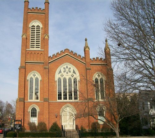
14 listings: 8 buildings, 3 historic districts, the Harmar Historic District, the Marietta Historic District and the Cisler Terrace, with 2,301 contributing buildings, 1 site, and 2 structures. 2,310 historic buildings in all.
How old are the homes in Marietta?
42% of Marietta’s homes were built before 1940 (Census estimate, ±3.6 points), against a typical 15% for an Ohio town; the median home was built in 1954.
Founding dates: Wikidata, Wikipedia, the U.S. post office records of Blevins & Helbock (CC0) and the Census. Homes by year built: Census ACS 2020–24. National Register of Historic Places: National Park Service (list of May 22, 2026). Old photos, postcards and papers: Wikimedia Commons, the Library of Congress and other public archives, credited on each item’s page. Maps: U.S. Geological Survey historical topographic maps (via Esri) and Sanborn fire-insurance maps (Library of Congress). History text and census tables: Wikipedia (CC BY-SA 4.0). Places that used to be: USGS Geographic Names Information System (2021).
From the Library of Congress (2), Wikidata (3), the National Register of Historic Places (14), Wikipedia, Wikidata and Wikipedia for famous people, U.S. Geological Survey historical maps, U.S. Census counts (via Wikipedia), the US Post Offices dataset (Blevins & Helbock), the USGS Geographic Names Information System, Sanborn fire insurance maps (Library of Congress) and old county and town histories (Internet Archive). Archive images are copied here with their credits and licenses, shown on each photo’s page. Refreshed monthly.


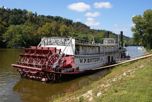 ★ Landmark







 1890


