Louisville dates to 1834, and 17% of its homes were built before 1940
More historic than 91% of U.S. towns · #137 of 993 in Ohio. What drives it
2 places in town are on the National Register, among them a historic district with 222 buildings. Below: 12 old photos and papers, maps from 1895 on, and the census since 1880.
Founding year: Wikidata. First post office: 1837.The full story ↓
History grade
What drives Louisville’s History grade
On its age, its old homes and the National Register, Louisville is more historic than 91% of U.S. towns, #137 of 993 in Ohio. All 3 inputs are above most U.S. towns; its National Register listings ranks highest and its share of homes from before 1940 lowest.
A
HistoryA character grade: shown, never part of Louisville’s overall grade.
Ohio towns list about as much on the Register as the country (a typical Ohio town has 2.9 per 10,000 residents, the U.S. 2.4), so Louisville’s 232 sits above most of its state (97% of Ohio towns have fewer) while its 223 historic buildings outnumber those of 94% of U.S. towns.
How sure. Graded on any two of the three inputs instead, the letter would range from A− to A. The pre-1940 share is a Census survey estimate (±4.4 points). Two sources give 1834.
Founding year: Wikidata (other dates in Quick answers). Homes: Census ACS 2020–24. National Register: National Park Service, May 2026 list; each listing counted once (boundary changes and added documentation belong to their listing), and a historic district counts its contributing buildings. How TownRatings grades history →
What stands out about Louisville’s past
Read from the archive, the National Register and the record. The page puts what stands out first.
National Park Service, National Register of Historic Places. Photos from Wikimedia Commons, credited on each place’s page.
Every building
Louisville, building by building, 1895–1923
Fire insurance maps drew every building, what it was made of and what it was used for, so insurers could price the risk of fire. Pick a year, then a sheet.
Nothing in the archives for these yearsWeddings on Main Street, storms, parades, school pictures, the old store. If it’s in your family album, it belongs here.
On October 8, 1834, Louisville was formally settled by Henry Lautzenheiser, from Germany, and Frederick Fainot, a French Huguenot. The city was named after Lautzenheiser's son, Lewis, and called Lewisville, Ohio. The name of the town was also considered appropriate because it was initially surveyed by the similar-sounding name of Lewis Vail. When the post office was established in 1837, with Sam Petree as its first postmaster, it was discovered Ohio already had a Lewisville, so the spelling was changed to Louisville.
Passages that mention Louisville, cut from the printed page as they were published.
Rambles in the path of the steam-horse. An off-hand olla podrida, embracing a general historical and descriptive view of the scenery, agricultural and mineral resources, and prominent features of the travelled route from Baltimore to Harper's Ferry, Cumbe1855 · page 408Read the page →
Read the text
Jeffersonville is situated in Calrk county, Indiana, forty miles below Madison, and nearly opposite the city of Louisville, in Kentucky. Its situation is commanding and elevated, being immediately above the fiills of the Ohio river, and affording a delightful view of the city of Louisville, of the broad and winding stream, with its numerous boats and islands, and verdure, and of the lofty hills which embosom it in the distance.
Text read by machine from the scan; it may contain errors.
A standard history of Stark County, Ohio1916 · page 701Read the page →
Read the text
Julius Thurin. For many years the little City of Louisville has counted among its largest and most important business assets the family of Thurin. The late Julius Thurin worked out a broad and successful career at Louisville, was one of the early merchants and deserves to be remembered as the founder of the firm of Julius Thurin Sons, which until his death was the chief emporium for the handling of dry goods and carpets and was known as “the pioneer store.” It has since been developed under the management of his sons into the first department
Text read by machine from the scan; it may contain errors.
A standard history of Stark County, Ohio1916 · page 502Read the page →
Read the text
Louisville Platted In 1834, seven years after the platting of Harrisburg in the northeastern part of Nimishillen Township, Henry Loutzenheiser and Frederick Fanot laid out the Town of Louisville on their lands in section 28. It was originally named Lewisville, after a son of Loutzenheiser, but on application for a postoffice it was ascertained that one already existed in the state by that name; the spelling of the Stark County town was therefore designated as Louisville. The postoffice was established March
Text read by machine from the scan; it may contain errors.
History of Stark County, with an outline sketch of Ohio1881Read the page →
Read the text
Germany, and born in 1793. Henry Loutzenheiser, his father-in-law, was among the early settlers of Stark Co., and laid out the village of Louisville. Mr. Conrad labored upon the farm, and attended the log school-houses of his day, during his minority. After arriving at his majority he farmed the homestead for seven years, when he purchased his present
Text read by machine from the scan; it may contain errors.
Scans and text from the Internet Archive. Books published in 1930 or earlier, which are in the public domain.
Timeline
Louisville, 1834 to 1958
Woven from the archive, old maps, post office records, the National Register and the people born here.
In 1834, according to Wikidata. Louisville’s post office opened in 1837, and the census of 1880 counted 1,650 people here.
How does Louisville rank for history?
Louisville is more historic than 91% of U.S. towns, #137 of 993 in Ohio. The History grade combines the town’s founding era, the share of homes built before 1940 and its National Register listings. It’s a character grade, so it isn’t part of the overall grade. How it works.
What is on the National Register in Louisville?
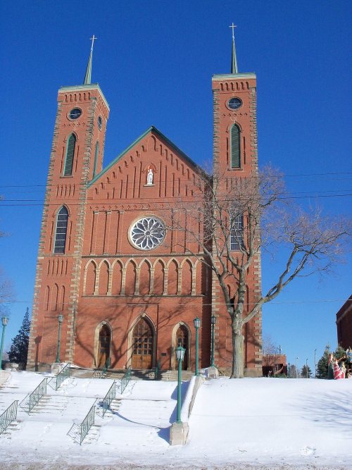
Two places: the St. Louis Church (listed 1979) and the Louisville Historic District (2011).
How old are the homes in Louisville?
17% of Louisville’s homes were built before 1940 (Census estimate, ±4.4 points), against a typical 15% for an Ohio town; the median home was built in 1973.
Founding dates: Wikidata, Wikipedia, the U.S. post office records of Blevins & Helbock (CC0) and the Census. Homes by year built: Census ACS 2020–24. National Register of Historic Places: National Park Service (list of May 22, 2026). Old photos, postcards and papers: Wikimedia Commons, the Library of Congress and other public archives, credited on each item’s page. Maps: U.S. Geological Survey historical topographic maps (via Esri) and Sanborn fire-insurance maps (Library of Congress). History text and census tables: Wikipedia (CC BY-SA 4.0). Places that used to be: USGS Geographic Names Information System (2021).
From Wikimedia Commons (12), the National Register of Historic Places (2), Wikipedia, Wikidata and Wikipedia for famous people, U.S. Geological Survey historical maps, U.S. Census counts (via Wikipedia), the US Post Offices dataset (Blevins & Helbock), the USGS Geographic Names Information System, Sanborn fire insurance maps (Library of Congress) and old county and town histories (Internet Archive). Archive images are copied here with their credits and licenses, shown on each photo’s page. Refreshed monthly.



 1899
 1899
 1899
 1899
 1899
 1899
 1899
 1899
 1899
 1899
 1899
 1915


