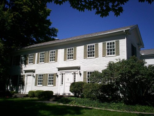
Its Register listings are the James A. Garfield House and the Thomas F. Young House. Its Register listings are the James A. Garfield House and the Thomas F. Young House. Below: 5 old photos and papers, maps from 1905 on, and the census since 1880.
Founding year: the first Hiram post office (Blevins & Helbock, CC0).
History grade
What drives Hiram’s History grade
On its age, its old homes and the National Register, Hiram is more historic than 93% of U.S. towns. All 3 inputs are above most U.S. towns; its share of homes from before 1940 ranks highest and its National Register listings lowest.
A
HistoryA character grade: shown, never part of Hiram’s overall grade.
Ohio towns list about as much on the Register as the country (a typical Ohio town has 2.9 per 10,000 residents, the U.S. 2.4), so Hiram’s 16.7 sits above most of its state (80% of Ohio towns have fewer) while its 2 listings outnumber those of 60% of U.S. towns.
How sure. Graded on any two of the three inputs instead, the letter would range from A− to A+. The pre-1940 share is a Census survey estimate (±22.6 points). The founding year is the first post office, not a stated founding date.
Founding year: the first post office (other dates in Quick answers). Homes: Census ACS 2020–24. National Register: National Park Service, May 2026 list; each listing counted once (boundary changes and added documentation belong to their listing), and a historic district counts its contributing buildings. How TownRatings grades history →
What stands out about Hiram’s past
Read from the archive, the National Register and the record. The page puts what stands out first.
Lost a third of its people between 1900 and 1940, then more than doubled.
14 censuses, 1880–2020.
U.S. Census Bureau decennial counts, from the census table on Hiram’s Wikipedia page.
On the map
Hiram on the map, 1905 to 1994
Every edition of the U.S. Geological Survey’s map of Hiram. Tap a year, or press play to watch the town change.
1905Garrettsville sheet · 1:62,500
U.S. Geological Survey historical topographic maps (public domain), via Esri’s collection of the scans. The red ring marks the center of Hiram.
The story so far
Hiram, in brief
Wikipedia doesn’t have a history of Hiram yet. The photos, dates and memories neighbors add here are how it gets written.
Hiram is a village in northern Portage County, Ohio, United States. It was formed from portions of Hiram Township in the Connecticut Western Reserve. The population was 996 at the 2020 census. Hiram is part of the Akron metropolitan area. It is the home of Hiram College, a small, private liberal arts college. The Hiram post office was established in 1816.
Its first post office opened in 1816. Between the 2010 and 2020 censuses its population fell from 1,406 to 996 (-29%).
Intro from Wikipedia. Population: U.S. Census Bureau.
From the old history books
What they wrote about Hiram in 1885
Passages that mention Hiram, cut from the printed page as they were published.
History of Portage County, Ohio1885 · page 461Read the page →
Read the text
Prior to 1865, at the time of the incorporation of the village, the school district was composed of District No. 2, Nelson Township, a district in the southeast corner of Hiram and a district in the northeast corner of Freedom; but the act of incorporation merged these three districts into one, under control of a Board of Education of the village, a vote of the people adopting the school law of 1849. May 13, 1867, a vote was taken to authorize the Board to levy a tax of 10 mills for school building purposes, and in 1869 a good brick building, large enough to accommodate 300 pupils, was completed
Text read by machine from the scan; it may contain errors.
History of Portage County, Ohio. Containing a history of the county, its townships, towns, villages, schools, churches, industries, etc1885 · page 299Read the page →
Read the text
road called the Olinton Air lAtM. It entered the State at Kinsman on the Pennsylvania line, and passed southwest throagh Trnmball, Geauga, Portage, and Summit Counties, thence onward in the sarae general direction. It struck the northonDi boundary of Hiram Township, in Lot 4, and passed south west ttirongh Hiram, Mantoa and Aurora Townships to Hudson, Snmmit Ooontj, crossing the Cleveland ft Mahoning Talley Railroad near the boundary line between Mantna and Aurora. Some efforts have recently been made to revive the project, but so far nothing definite has been effected, and it is very doubt-
Text read by machine from the scan; it may contain errors.
History of Portage County, Ohio. Containing a history of the county, its townships, towns, villages, schools, churches, industries, etc1885 · page 239Read the page →
Read the text
Hiram Township, which originally com[iriHt> l the territory now known as Hiram, Mantua, Shalnrsvillo, Freedom, Windham and Nelson, received its first settlers in 1802, when Elijah Mason, Eiisha Hutchinson and Mason Tilden came in and settled respectively as follows: ilfason, who was from Lebanon, Conn., selected the west half of Lot 28; Hutcbineon, who was from Herkimer County, N. Y. , also selected a |>ortion of Lot 23, and Tilden, from Connecticut, selected Lot 22. In the fall thoy all returned to their homos in the East. John Fleming came about the same time, but remained only one year.
Text read by machine from the scan; it may contain errors.
History of Portage County, Ohio1885 · page 469Read the page →
Read the text
There is some doubt respecting the first settler in Hiram. By some it is thought that Abraham S. Honey, who made the first settlement in Mantua, was the man, and that he came as early as 1799, but that cannot be, for he, with his brother-in-law, Rufus Edwards, settled in Mantua, or at least made some improvements there, in the fall of 1798. Mr. John Harmon, one of the first settlers in Mantua, was under the impression that a man named William W.
Text read by machine from the scan; it may contain errors.
Scans and text from the Internet Archive. Books published in 1930 or earlier, which are in the public domain.
Timeline
Hiram, 1816 to 1970
Woven from the archive, old maps, post office records, the National Register and the people born here.
Nothing in the archives for these yearsWeddings on Main Street, storms, parades, school pictures, the old store. If it’s in your family album, it belongs here.
The Hiram post office opened in 1816, the earliest record of the town by name (U.S. post office records).
How does Hiram rank for history?
Hiram is more historic than 93% of U.S. towns. The History grade combines the town’s founding era, the share of homes built before 1940 and its National Register listings. It’s a character grade, so it isn’t part of the overall grade. How it works.
What is on the National Register in Hiram?
Two places: the James A. Garfield House (listed 1975) and the Thomas F. Young House (1976).
How old are the homes in Hiram?
50% of Hiram’s homes were built before 1940 (Census estimate, ±22.6 points), against a typical 15% for an Ohio town; the median home was built in 1943.
Founding dates: Wikidata, Wikipedia, the U.S. post office records of Blevins & Helbock (CC0) and the Census. Homes by year built: Census ACS 2020–24. National Register of Historic Places: National Park Service (list of May 22, 2026). Old photos, postcards and papers: Wikimedia Commons, the Library of Congress and other public archives, credited on each item’s page. Maps: U.S. Geological Survey historical topographic maps (via Esri) and Sanborn fire-insurance maps (Library of Congress). History text and census tables: Wikipedia (CC BY-SA 4.0). Places that used to be: USGS Geographic Names Information System (2021).
From Wikimedia Commons (18), the National Register of Historic Places (2), Wikidata and Wikipedia for famous people, U.S. Geological Survey historical maps, U.S. Census counts (via Wikipedia), the US Post Offices dataset (Blevins & Helbock), the USGS Geographic Names Information System and old county and town histories (Internet Archive). Archive images are copied here with their credits and licenses, shown on each photo’s page. Refreshed monthly.


 1914
 1916
 1916
 2014
 2014
 2014
 2014
 2014
 2014
 2014
 2014
 2009
 2009
 2008
 2007
 2004