The Grafton post office opened in 1825, the earliest record of the town by name. Two smaller post offices, Grafton Station (1852) and Rawsonville (1852), opened inside today’s town and later closed.
First census: 600 in 18902020 census: 5,895201 years
How historic is Grafton?
B+
More historic than 75% of U.S. towns, on its age, its old homes and the National Register.
Founding year: the first Grafton post office (Blevins & Helbock, CC0).The full story ↓
History grade
What drives Grafton’s History grade
On its age, its old homes and the National Register, Grafton is more historic than 75% of U.S. towns, #371 of 993 in Ohio. All 3 inputs are above most U.S. towns; its age ranks highest and its share of homes from before 1940 lowest.
B+
HistoryA character grade: shown, never part of Grafton’s overall grade.
Ohio towns list about as much on the Register as the country (a typical Ohio town has 2.9 per 10,000 residents, the U.S. 2.4), so Grafton’s 3.5 sits near the middle of its state (58% of Ohio towns have fewer) while its 2 listings outnumber those of 60% of U.S. towns.
How sure. Graded on any two of the three inputs instead, the letter would range from B to B+. The pre-1940 share is a Census survey estimate (±4.8 points). The founding year is the first post office, not a stated founding date.
Founding year: the first post office (other dates in Quick answers). Homes: Census ACS 2020–24. National Register: National Park Service, May 2026 list; each listing counted once (boundary changes and added documentation belong to their listing), and a historic district counts its contributing buildings. How TownRatings grades history →
What stands out about Grafton’s past
Read from the archive, the National Register and the record. The page puts what stands out first.
In 1846, Grafton was platted when the railroad was extended to that point. The village's name may be a transfer from Grafton, Massachusetts. To avoid confusion with Grafton Township and the communities of Grafton Center and Grafton Station, Grafton was renamed to Rawsonville in May 1852. The name reverted to Grafton upon incorporation as a village on January 1, 1877. On September 30, 1990, Grafton withdrew from Grafton and Eaton townships by forming a paper township named Rawsonville Township.
the ai)()earance of rough saloons, which show increasing business in that ti'affic, following the "oil speculation" that gathers at the center of Grafton. i The improvements made in Grafton since 1840, will be given by the gentlemanly historian who has lately visited the township, and is prepared with dates and names of important organizations formed in Grafton and Kawsonvillc since that date. Only eight
Text read by machine from the scan; it may contain errors.
History of Lorain County, Ohio1879 · page 260Read the page →
Read the text
In writiug this brief account of the first settlement of Grafton, it is often found to be painful to pass so lightly over families and friends, when even the writing of a name brings the history of joys and sorrows of their life before us. A stranger can step rapidly among the graves of households in Grafton to-day witliout a pang; but not so with one who lived there when the first graves were made, their loss then
Text read by machine from the scan; it may contain errors.
A standard history of Lorain county, Ohio1916Read the page →
Read the text
Township Incorporated Medina County was not civilly organized until January, 1818, and on the 25th of the following July its connnissioners incorporated the Township of Grafton. At the first election held in August, 1818, Eliphalet Jones, William Ingersoll and William Ji. Crittenden were elected trustees; AVilliam Bishop, clerk; Reuben Ingersoll, trea.surer; David Ashley, appraiser of property; Grindel Rawson and Seth C.
Text read by machine from the scan; it may contain errors.
The ancestry of Grafton Johnson1924 · page 316Read the page →
Read the text
named after another president and added about 1854, stood as its sole companion during the student days of the second Grafton Johnson. Though this institution was founded by ardent Baptists of Indiana, it has won the support of ad¬ herents of that faith elsewhere, one of its donors being John D. Rockefeller, Sr., who on two occasions has given sums amounting to $25,000. That the general manager of the drive for funds is Doctor Charles E. Goodell, president
Text read by machine from the scan; it may contain errors.
Scans and text from the Internet Archive. Books published in 1930 or earlier, which are in the public domain.
Timeline
Grafton, 1825 to 2010
Woven from the archive, old maps, post office records, the National Register and the people born here.
Fire insurance maps drew every building, what it was made of and what it was used for, so insurers could price the risk of fire. Pick a year, then a sheet.
1904Sheet 1 of 1
Edition
Sheets
BrickWoodStone
Sanborn Map Company, via the Library of Congress. Editions published in 1930 or earlier, which are in the public domain.
On the National Register
2 historic places in Grafton
The country’s official list of buildings and places worth saving.
The Grafton post office opened in 1825, the earliest record of the town by name (U.S. post office records).
How does Grafton rank for history?
Grafton is more historic than 75% of U.S. towns, #371 of 993 in Ohio. The History grade combines the town’s founding era, the share of homes built before 1940 and its National Register listings. It’s a character grade, so it isn’t part of the overall grade. How it works.
What is on the National Register in Grafton?
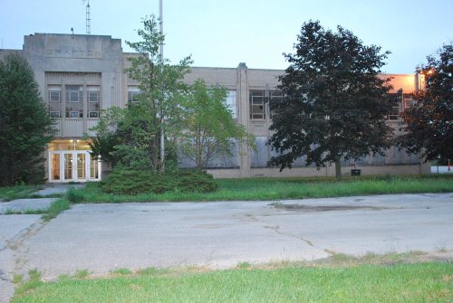
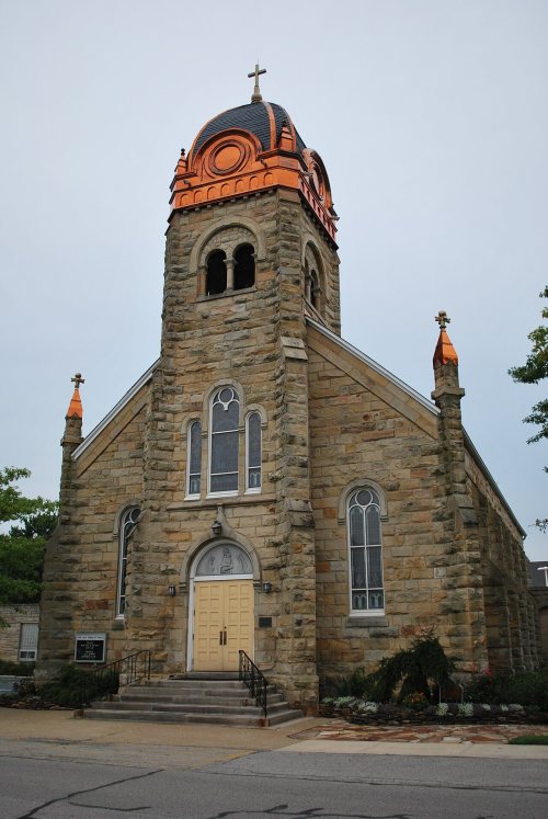
Two places: the Immaculate Conception Church (listed 1976) and the Grafton School (2008).
How old are the homes in Grafton?
15% of Grafton’s homes were built before 1940 (Census estimate, ±4.8 points), against a typical 15% for an Ohio town; the median home was built in 1976.
Founding dates: Wikidata, Wikipedia, the U.S. post office records of Blevins & Helbock (CC0) and the Census. Homes by year built: Census ACS 2020–24. National Register of Historic Places: National Park Service (list of May 22, 2026). Old photos, postcards and papers: Wikimedia Commons, the Library of Congress and other public archives, credited on each item’s page. Maps: U.S. Geological Survey historical topographic maps (via Esri) and Sanborn fire-insurance maps (Library of Congress). History text and census tables: Wikipedia (CC BY-SA 4.0). Places that used to be: USGS Geographic Names Information System (2021).
From Wikimedia Commons (6), the National Register of Historic Places (2), Wikipedia, Wikidata and Wikipedia for famous people, U.S. Geological Survey historical maps, U.S. Census counts (via Wikipedia), the US Post Offices dataset (Blevins & Helbock), the USGS Geographic Names Information System, Sanborn fire insurance maps (Library of Congress) and old county and town histories (Internet Archive). Archive images are copied here with their credits and licenses, shown on each photo’s page. Refreshed monthly.



 2024
 2024
 2024
 2015
 2012
 2004