East Liverpool dates to 1796, and 43% of its homes were built before 1940
More historic than 98% of U.S. towns · #24 of 993 in Ohio. What drives it
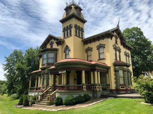
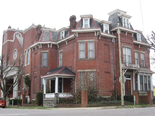
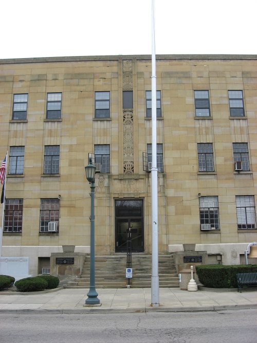
20 places in town are on the National Register, among them the Beginning Point of the U.S. Public Land Survey, a National Historic Landmark, and four historic districts with 108 buildings between them. 20 places in town are on the National Register, among them the Beginning Point of the U.S. Public Land Survey, a National Historic Landmark, and four historic districts with 108 buildings between them. Below: 8 old photos and papers, maps from 1887 on, and the census since 1830.
Founding year: Wikidata. First post office: 1806.The full story ↓
History grade
What drives East Liverpool’s History grade
On its age, its old homes and the National Register, East Liverpool is more historic than 98% of U.S. towns, #24 of 993 in Ohio. All 3 inputs are above most U.S. towns; its share of homes from before 1940 ranks highest and its age lowest.
A+
HistoryA character grade: shown, never part of East Liverpool’s overall grade.
Ohio towns list about as much on the Register as the country (a typical Ohio town has 2.9 per 10,000 residents, the U.S. 2.4), so East Liverpool’s 129 sits above most of its state (94% of Ohio towns have fewer) while its 126 historic buildings outnumber those of 91% of U.S. towns.
NoteThe founding year comes from Wikidata alone; no second source gives 1796.
How sure. Graded on any two of the three inputs instead, the letter would range from A to A+. The pre-1940 share is a Census survey estimate (±6.2 points).
Founding year: Wikidata (other dates in Quick answers). Homes: Census ACS 2020–24. National Register: National Park Service, May 2026 list; each listing counted once (boundary changes and added documentation belong to their listing), and a historic district counts its contributing buildings. How TownRatings grades history →
What stands out about East Liverpool’s past
Read from the archive, the National Register and the record. The page puts what stands out first.
National Park Service, National Register of Historic Places. Photos from Wikimedia Commons, credited on each place’s page.
Places that used to be
Lost post offices, old corners, places now gone and burying grounds
East Liverpool’s post office has been open since 1836. Four other post offices opened and closed inside today’s town.
Fawcettstown
1806–1824
Collins
1831–1836
East Liverpool
1836–today
Saint Clair
1848–1918
Klondyke
1911–1933
18001910today
Hamlets and corners on the map
Dry RunEast EndGlendaleJethroPleasant Heights
Gone or out of use
Central SchoolschoolFellowship Tabernacle ChurchchurchHorace Mann Public SchoolschoolOrchard Grove Methodist Episcopal ChurchchurchPrayer Temple Churchchurch
2cemeteries and burying grounds inside East Liverpool
RiverviewSpring Grove
US Post Offices dataset (Blevins & Helbock, CC0). Places and cemeteries from the USGS Geographic Names Information System (2021).
Native American petroglyphs exist in the area surrounding East Liverpool, including on Babbs Island and near the Little Beaver Creek. Before the arrival of European Americans, Mingo, Lenape, and Wyandot peoples lived in the area until the Battle of Fallen Timbers led to the Ohio Country's colonization by European-Americans.
Passages that mention East Liverpool, cut from the printed page as they were published.
History of Columbiana county, Ohio1879 · page 176Read the page →
Read the text
The village of East Liverpool was incorporated Jan. 4, 1834, and is the only village in the township. It is the seat of the most important pottery-manufacturing interest in America, is a landing-place for all steamboats plying on the Ohio between Pittsburgh and Cairo, and is also an important station on the Cleveland and Pittsburgh Railroad, being four miles below the State line, forty-four miles below Pittsburgh, and the same distance above
Text read by machine from the scan; it may contain errors.
History of Columbiana County, Ohio1905 · page 130Read the page →
Read the text
The gas-wells at East Liverpool lasted for over 10 years. Then gas in great quantitieswas struck in the Miller field, two miles east of Fairview, West Virginia, seven miles from East Liverpool, and the Ohio Valley Gas Company was organized by Pittsburg capital to pipe the product to East Liverpool. An 8-inch main was run from the West Virginia field,
Text read by machine from the scan; it may contain errors.
History of Columbiana county, Ohio1879 · page 185Read the page →
Read the text
Sept. 16, 1856, the first through railroad-train from East Liverpool to Pittsburgh, over the Cincinnati and Pittsburgh Railroad, went out with an excursion-party to a Fremont barbecue at the latter city. There was no depot at the town, and Mr. Andrew Blythe, the company’s first agent, sold tickets from the front door-step of his house, on Broadway near the river. Previous to the date named trains had been running from Cleveland to Wellsville, and
Text read by machine from the scan; it may contain errors.
History of Columbiana County, Ohio1905 · page 479Read the page →
Read the text
Two years prior to removing all their interests to Sebring, our, subject and his brother, Elsworth H., started The French China Company at East Liverpool. When their proposed plans were completed, the brothers amalgamated all their interests and incorporated The Sebring Pottery Company in 1889, the different names under, which their industries
Text read by machine from the scan; it may contain errors.
Scans and text from the Internet Archive. Books published in 1930 or earlier, which are in the public domain.
Timeline
East Liverpool, 1786 to 1970
Woven from the archive, old maps, post office records, the National Register and the people born here.
Nothing in the archives for these yearsWeddings on Main Street, storms, parades, school pictures, the old store. If it’s in your family album, it belongs here.
Every edition of the U.S. Geological Survey’s map of East Liverpool. Tap a year, or press play to watch the town change.
1937Wellsville sheet · 1:62,500
U.S. Geological Survey historical topographic maps (public domain), via Esri’s collection of the scans. The red ring marks the center of East Liverpool.
Every building
East Liverpool, building by building, 1887–1923
Fire insurance maps drew every building, what it was made of and what it was used for, so insurers could price the risk of fire. Pick a year, then a sheet.
In 1796, according to Wikidata. East Liverpool’s post office opened in 1806, and the census of 1830 counted 136 people here.
How does East Liverpool rank for history?
East Liverpool is more historic than 98% of U.S. towns, #24 of 993 in Ohio. The History grade combines the town’s founding era, the share of homes built before 1940 and its National Register listings. It’s a character grade, so it isn’t part of the overall grade. How it works.
What is on the National Register in East Liverpool?
20 listings: 15 buildings, 4 historic districts with 108 contributing buildings, and 1 site. 126 historic buildings in all.
How old are the homes in East Liverpool?
43% of East Liverpool’s homes were built before 1940 (Census estimate, ±6.2 points), against a typical 15% for an Ohio town; the median home was built in 1947.
Founding dates: Wikidata, Wikipedia, the U.S. post office records of Blevins & Helbock (CC0) and the Census. Homes by year built: Census ACS 2020–24. National Register of Historic Places: National Park Service (list of May 22, 2026). Old photos, postcards and papers: Wikimedia Commons, the Library of Congress and other public archives, credited on each item’s page. Maps: U.S. Geological Survey historical topographic maps (via Esri) and Sanborn fire-insurance maps (Library of Congress). History text and census tables: Wikipedia (CC BY-SA 4.0). Places that used to be: USGS Geographic Names Information System (2021).
From Wikimedia Commons (8), Wikidata (4), the National Register of Historic Places (20), Wikipedia, Wikidata and Wikipedia for famous people, U.S. Geological Survey historical maps, U.S. Census counts (via Wikipedia), the US Post Offices dataset (Blevins & Helbock), the USGS Geographic Names Information System, Sanborn fire insurance maps (Library of Congress) and old county and town histories (Internet Archive). Archive images are copied here with their credits and licenses, shown on each photo’s page. Refreshed monthly.


 ★ Landmark




 1906
 1907
 1907
 1908
 1908
 1908
 1908


