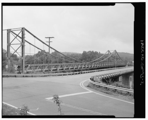
Its Register listings are the Dresden Suspension Bridge and the George W. Adams House. Its Register listings are the Dresden Suspension Bridge and the George W. Adams House. Below: 4 old photos and papers, maps from 1910 on, and the census since 1830.
Founding year: the first Dresden post office (Blevins & Helbock, CC0).The full story ↓
History grade
What drives Dresden’s History grade
On its age, its old homes and the National Register, Dresden is more historic than 87% of U.S. towns. All 3 inputs are above most U.S. towns; its share of homes from before 1940 ranks highest and its National Register listings lowest.
A
HistoryA character grade: shown, never part of Dresden’s overall grade.
Ohio towns list about as much on the Register as the country (a typical Ohio town has 2.9 per 10,000 residents, the U.S. 2.4), so Dresden’s 11.6 sits above most of its state (76% of Ohio towns have fewer) while its 2 listings outnumber those of 60% of U.S. towns.
How sure. Graded on any two of the three inputs instead, the letter would still be A−. The pre-1940 share is a Census survey estimate (±7.2 points). The founding year is the first post office, not a stated founding date.
Founding year: the first post office (other dates in Quick answers). Homes: Census ACS 2020–24. National Register: National Park Service, May 2026 list; each listing counted once (boundary changes and added documentation belong to their listing), and a historic district counts its contributing buildings. How TownRatings grades history →
What stands out about Dresden’s past
Read from the archive, the National Register and the record. The page puts what stands out first.
Dresden is located on or near the site of a Shawnee (Native American) village known as Wakatomika, which gave its name to Wakatomika Creek, the creek that empties into the Muskingum River near the northern edge of the village. These were the easternmost of the Shawnee villages, and the home of the most hostile of that tribe. David Zeisberger, the Moravian missionary, preached there in 1773 in an effort to convert them; but the wrongs done to Chief Logan and other Ohio Native Americans were discussed at this place with much rancor, and war parties had been going out from here against the white settlers in spite of attempts by the Delaware (tribe) to intercede. On August 7, 1774, Colonel Angus McDonald brought 400 men from Fort Pittsburg in the Wakatomica Campaign of Lord Dunmore's War to fight the Shawnee. The settlement of Wakatomika, as well as four other villages, was burned to the gr…
Passages that mention Dresden, cut from the printed page as they were published.
1794. History of Muskingum County, Ohio, with illustrations and biographical sketches of prominent men and pioneers1882 · page 353Read the page →
Read the text
The present Dresden cemetery was laid out in 1829, and is owned by the village of Dresden. It contains twelve acres, and is beautifully laid out.
Text read by machine from the scan; it may contain errors.
1794. History of Muskingum County, Ohio, with illustrations and biographical sketches of prominent men and pioneers1882 · page 358Read the page →
Read the text
The church (the only one in Jefferson township of this denomination) is located near the railroad track, in the village of Dresden. The present membership is about sixty. They have no Sunday School.
Text read by machine from the scan; it may contain errors.
Biographical and historical memoirs of Muskingum County, Ohio1892 · page 364Read the page →
Read the text
is traversed by the Cleveland & Canton and Cincinnati & Muskingum Valley railroads. Ellis, eight miles north of Zanesville, and seven miles south of Dresden, in the eastern jrart of this township, on the western bank of the Muskingum river, a station on these lines was founded, and its postoffice was established a little more than twenty years ago.
Text read by machine from the scan; it may contain errors.
Biographical and historical memoirs of Muskingum County, Ohio1892 · page 104Read the page →
Read the text
In 1838 the locks at Dresden and Simm’s creek were completed and navigation for small steamboats was opened to the entrance of the Ohio canal at Dresden. The shipment of flour to New York began by that route, as the improvement on the lower Muskingum kept navigation closed from 1837 to 1842. Warehouses were built on the river bank near Market street.
Text read by machine from the scan; it may contain errors.
Scans and text from the Internet Archive. Books published in 1930 or earlier, which are in the public domain.
By decade
Dresden, decade by decade
2 decades in the archive, from the 1880s to the 1910s. Scroll each row; tap a photo for its story.
Nothing in the archives for these yearsWeddings on Main Street, storms, parades, school pictures, the old store. If it’s in your family album, it belongs here.
The Dresden post office opened in 1818, the earliest record of the town by name (U.S. post office records).
How does Dresden rank for history?
Dresden is more historic than 87% of U.S. towns. The History grade combines the town’s founding era, the share of homes built before 1940 and its National Register listings. It’s a character grade, so it isn’t part of the overall grade. How it works.
What is on the National Register in Dresden?
Two places: the Dresden Suspension Bridge (listed 1978) and the George W. Adams House (1979).
How old are the homes in Dresden?
25% of Dresden’s homes were built before 1940 (Census estimate, ±7.2 points), against a typical 15% for an Ohio town; the median home was built in 1976.
Founding dates: Wikidata, Wikipedia, the U.S. post office records of Blevins & Helbock (CC0) and the Census. Homes by year built: Census ACS 2020–24. National Register of Historic Places: National Park Service (list of May 22, 2026). Old photos, postcards and papers: Wikimedia Commons, the Library of Congress and other public archives, credited on each item’s page. Maps: U.S. Geological Survey historical topographic maps (via Esri) and Sanborn fire-insurance maps (Library of Congress). History text and census tables: Wikipedia (CC BY-SA 4.0). Places that used to be: USGS Geographic Names Information System (2021).
From Wikimedia Commons (6), the National Register of Historic Places (2), Wikipedia, U.S. Geological Survey historical maps, U.S. Census counts (via Wikipedia), the US Post Offices dataset (Blevins & Helbock), the USGS Geographic Names Information System, Sanborn fire insurance maps (Library of Congress) and old county and town histories (Internet Archive). Archive images are copied here with their credits and licenses, shown on each photo’s page. Refreshed monthly.


 1888
 1915
 2015
 2004