On its age, its old homes and the National Register, Carey is more historic than 87% of U.S. towns, #193 of 993 in Ohio. All 3 inputs are above most U.S. towns; its share of homes from before 1940 ranks highest and its National Register listings lowest.
A
HistoryA character grade: shown, never part of Carey’s overall grade.
Ohio towns list about as much on the Register as the country (a typical Ohio town has 2.9 per 10,000 residents, the U.S. 2.4), so Carey’s 2.8 sits near the middle of its state (55% of Ohio towns have fewer) while its 1 listings outnumber those of 51% of U.S. towns.
NoteThe founding year comes from Wikipedia alone; no second source gives 1843.
How sure. Graded on any two of the three inputs instead, the letter would range from B+ to A. The pre-1940 share is a Census survey estimate (±6.6 points).
Founding year: Wikipedia (other dates in Quick answers). Homes: Census ACS 2020–24. National Register: National Park Service, May 2026 list; each listing counted once (boundary changes and added documentation belong to their listing), and a historic district counts its contributing buildings. How TownRatings grades history →
What stands out about Carey’s past
Read from the archive, the National Register and the record. The page puts what stands out first.
Every edition of the U.S. Geological Survey’s map of Carey. Tap a year, or press play to watch the town change.
1907Upper Sandusky sheet · 1:62,500
U.S. Geological Survey historical topographic maps (public domain), via Esri’s collection of the scans. The red ring marks the center of Carey.
Every building
Carey, building by building, 1893–1916
Fire insurance maps drew every building, what it was made of and what it was used for, so insurers could price the risk of fire. Pick a year, then a sheet.
The village is near Sheriden Cave, where habitation occurred around 11,000BC.
The village of Carey was founded in 1843 when W. J. Buell and R. M. Shuler laid out the town on land that they owned. The town was named after Judge John Carey, an early prominent resident.
Carey is home to an early settlement of Luxembourgers that continues to uphold its Luxembourg heritage today. Each year, an annual pilgrimage honoring Our Lady, Consoler of the Afflicted, is attended by crowds of people. The event features a religious procession starting in the neighboring community of Frenchtown and ending in Carey, seven miles away. The procession symbolizes the long journey of Luxembourg immigrants and their search for new life in the United States.
Passages that mention Carey, cut from the printed page as they were published.
The history of Wyandot county, Ohio, containing a history of the county1884 · page 751Read the page →
Read the text
It will be seen that the town of Carey was laid out two years previous to the organization of Wyandot County, and this fact, after all that has been said in regard to the general development of the county in previous chapters, is sufficient evidence to most readers, no doubt, that the territory of the vicinity in which Carey is located was exceedingly wild and uncultivated at the period of its history above referred to.
Text read by machine from the scan; it may contain errors.
The history of Wyandot county, Ohio, containing a history of the county1884 · page 407Read the page →
Read the text
High School Statistics: Total receipts for school purposes within the year, at Upper Sandusky, $31,014.21; at Carey, $5,210.54; at Nevada, $6,414.17; total expenditui-es at Upper Sandusky, $15,073.80; at Carey, $2,358.60; at Nevada, $5,575.13. Number of schoolhouses at Upper Sandusky, 3; at Carey 1; at Nevada, 1. Number of schoolrooms at Upper Sanduskv, 11; at Carey, 4; at Nevada. 6 Value of school property at Upper Sandusky, $18,000;* at Carey, $7,000; at Nevada, $14,000. Number of teachers employed at Upper Sandusky, gentlemen, 2; ladies, 10; at
Text read by machine from the scan; it may contain errors.
Scans and text from the Internet Archive. Books published in 1930 or earlier, which are in the public domain.
Timeline
Carey, 1833 to 1912
Woven from the archive, old maps, post office records, the National Register and the people born here.
Nothing in the archives for these yearsWeddings on Main Street, storms, parades, school pictures, the old store. If it’s in your family album, it belongs here.
In 1843, according to Wikipedia’s history of the town. the census of 1870 counted 692 people here.
How does Carey rank for history?
Carey is more historic than 87% of U.S. towns, #193 of 993 in Ohio. The History grade combines the town’s founding era, the share of homes built before 1940 and its National Register listings. It’s a character grade, so it isn’t part of the overall grade. How it works.
What is on the National Register in Carey?
One place: the West End Elementary School (listed 1987).
How old are the homes in Carey?
41% of Carey’s homes were built before 1940 (Census estimate, ±6.6 points), against a typical 15% for an Ohio town; the median home was built in 1952.
Founding dates: Wikidata, Wikipedia, the U.S. post office records of Blevins & Helbock (CC0) and the Census. Homes by year built: Census ACS 2020–24. National Register of Historic Places: National Park Service (list of May 22, 2026). Old photos, postcards and papers: Wikimedia Commons, the Library of Congress and other public archives, credited on each item’s page. Maps: U.S. Geological Survey historical topographic maps (via Esri) and Sanborn fire-insurance maps (Library of Congress). History text and census tables: Wikipedia (CC BY-SA 4.0). Places that used to be: USGS Geographic Names Information System (2021).
From Wikimedia Commons (11), Wikidata (1), the National Register of Historic Places (1), Wikipedia, Wikidata and Wikipedia for famous people, U.S. Geological Survey historical maps, U.S. Census counts (via Wikipedia), the USGS Geographic Names Information System, Sanborn fire insurance maps (Library of Congress) and old county and town histories (Internet Archive). Archive images are copied here with their credits and licenses, shown on each photo’s page. Refreshed monthly.
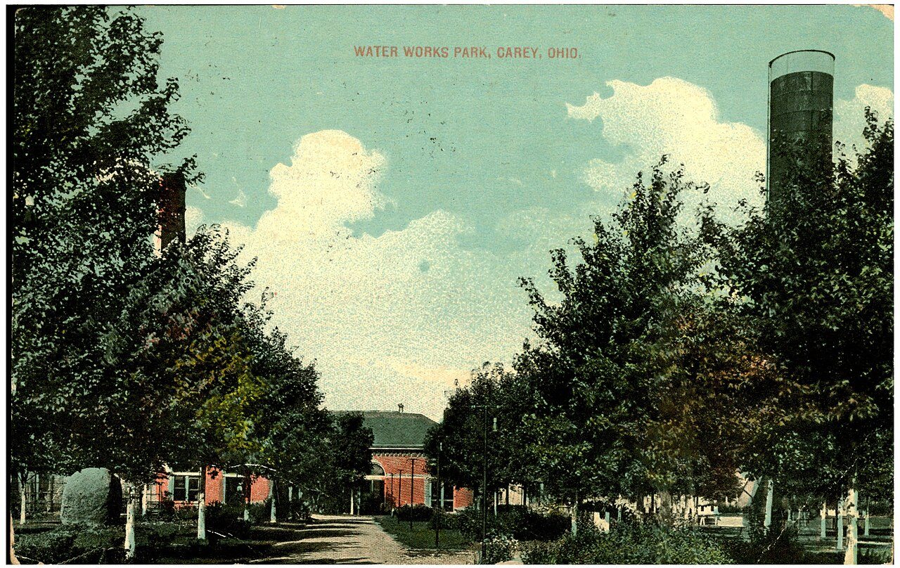


 1912
 1913
 1914
 1914
 1915
 1915
 2007
 2007
 2007
 2007