


The story
Read it all →How Berlin Heights came to be
From Wikipedia’s history of Berlin Heights.
In the late 1850s a branch of the "free love" movement was established in Berlin Heights.
Text from Wikipedia, licensed CC BY-SA 4.0.
Each edition grades its towns against each other only.
Below: 2 old photos and papers, maps from 1903 on, and the census since 1880.
The Berlin Heights post office opened in 1854, the earliest record of the town by name.
Read from the archive, the National Register and the record. The page puts what stands out first.
The first neighbors to add old photos shape how Berlin Heights’s history is told.
Every edition of the U.S. Geological Survey’s map of Berlin Heights. Tap a year, or press play to watch the town change.

U.S. Geological Survey historical topographic maps (public domain), via Esri’s collection of the scans. The red ring marks the center of Berlin Heights.
From Wikipedia’s history of Berlin Heights.
In the late 1850s a branch of the "free love" movement was established in Berlin Heights.
Text from Wikipedia, licensed CC BY-SA 4.0.
Passages that mention Berlin Heights, cut from the printed page as they were published.

Berlin Heights has a wide reputation, and had it been directly on the line of the railroad would have grown much more rapidly than it has done. It has several stores, several manufactories, a saw-mill, a grist-mill, a fine schoolbuilding with graded school, three churches and a hotel.
Text read by machine from the scan; it may contain errors.
Berlin Heights has had a wide reputation, but its growth has been hampered by not having railroad facilities. It has several stores, several factories, a sawmill, a grist mill, a fine school building with graded school, three churches and a hotel.
Text read by machine from the scan; it may contain errors.
After his marriage Mr. Romell bought his first farm, comprising forty acres, in the vicinity of Castalia, but some years afterward bought another place in Huron County, and conducted it until 1891. He then came to the Village of Berlin Heights and for five years was well known to that community as proprietor of a popular hotel. In 1896 he bought thirty-four acres half a mile east of the village, and still owns that farm,
Text read by machine from the scan; it may contain errors.
Ceylon on the Lake Shore and Michigan Southern Railroad is directly north of Berlin Heights, and grew to its present size in an incredibly short time. It has two stores, two saloons, a hotel, a post-office and a sawmill. There are six cemeteries in the township, one of which is being washed away by the united force of Chapelle Creek and the lake. The others are at Berlinville, Berlin Heights and Harpen’s Corners.
Text read by machine from the scan; it may contain errors.Scans and text from the Internet Archive. Books published in 1930 or earlier, which are in the public domain.
Woven from the archive, old maps, post office records, the National Register and the people born here.
 Born hereHudson Tuttle is born here
 Born herePaul Drennan Cravath is born here
 Born hereMartin Ittner is born here
 On the mapFirst mapped by the U.S. Geological Survey
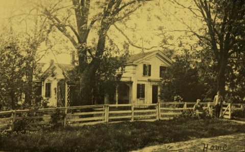 In the archiveTuttle home, Walnut Grove Farm, Berlin Heights, Ohio (A golden sheaf, 1907)
One decade in the archive so far: the 1900s. Scroll each row; tap a photo for its story.
No then-and-now pairs yet. Take a photo from the same spot as an old one and they appear here side by side.

Find the spot, match the angle, and add your photo. It becomes the first then-and-now pair on Berlin Heights’ page.
Retake this view · +15Between 424 and 828 people in every census since 1880.
15 censuses, 1880–2020.
U.S. Census Bureau decennial counts, from the census table on Berlin Heights’ Wikipedia page.
Writers, athletes, leaders and more, ranked by how widely they’re known.
US Post Offices dataset (Blevins & Helbock, CC0). Places and cemeteries from the USGS Geographic Names Information System (2021).
The Berlin Heights post office opened in 1854, the earliest record of the town by name (U.S. post office records).
What the archives can’t tell you, neighbors can.
Founding dates: Wikidata, Wikipedia, the U.S. post office records of Blevins & Helbock (CC0) and the Census. Homes by year built: Census ACS 2020–24. National Register of Historic Places: National Park Service (list of May 22, 2026). Old photos, postcards and papers: Wikimedia Commons, the Library of Congress and other public archives, credited on each item’s page. Maps: U.S. Geological Survey historical topographic maps (via Esri) and Sanborn fire-insurance maps (Library of Congress). History text and census tables: Wikipedia (CC BY-SA 4.0). Places that used to be: USGS Geographic Names Information System (2021). How TownRatings grades history →
From Wikimedia Commons (4), Wikidata (1), Wikipedia, Wikidata and Wikipedia for famous people, U.S. Geological Survey historical maps, U.S. Census counts (via Wikipedia), the US Post Offices dataset (Blevins & Helbock), the USGS Geographic Names Information System and old county and town histories (Internet Archive). Archive images are copied here with their credits and licenses, shown on each photo’s page. Refreshed monthly.
 Date?
 2015
 2004