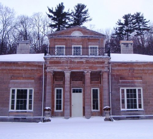
6 places in town are on the National Register, among them the Hyde Hall, a National Historic Landmark. Below: 1 old photo or paper from 1866 on and old-book passages.
Founding year: Wikidata. First post office: 1807.The full story ↓
History grade
What drives Springfield’s History grade
On its age, its old homes and the National Register, Springfield is more historic than 98% of U.S. towns. All 3 inputs are above most U.S. towns; its age ranks highest and its National Register listings lowest.
A+
HistoryA character grade: shown, never part of Springfield’s overall grade.
New York towns list more on the Register than most of the country (a typical New York town has 12.3 per 10,000 residents, the U.S. 2.4), so Springfield’s 94.5 sits above most of its state (75% of New York towns have fewer) while its 9 historic buildings outnumber those of 75% of U.S. towns.
NoteThe founding year comes from Wikidata alone; no second source gives 1762.
How sure. Graded on any two of the three inputs instead, the letter would range from A to A+. The pre-1940 share is a Census survey estimate (±11.8 points).
Founding year: Wikidata (other dates in Quick answers). Homes: Census ACS 2020–24. National Register: National Park Service, May 2026 list; each listing counted once (boundary changes and added documentation belong to their listing), and a historic district counts its contributing buildings. How TownRatings grades history →
What stands out about Springfield’s past
Read from the archive, the National Register and the record. The page puts what stands out first.
Several families settled near Otsego Lake circa 1762, but little further development occurred until after the American Revolution.
Springfield was formed from part of the Town of Cherry Valley in 1797. Growing hops was a major agricultural pursuit.
In 1778, Joseph Brant, native leader, led an expedition that burned the town and took captives. Lieutenant Colonel Jacob Ford wrote a letter to General Abraham Ten Broeck informing him of the destruction of Springfield.
Passages that mention Springfield, cut from the printed page as they were published.
A standard history of Springfield and Clark County, Ohio1922 · page 53Read the page →
Read the text
Outstanding Dates It was on St. Patrick's day, 1801, that Springfield first claimed "its place in the sun," but not until January 23, 1827, did the State Legislature recognize the "incorporated town of Springfield," and not until May 14, 1850, was Springfield incorporated as a city. While it has had citymanager-commission form of government since January 1, 1914, under the original form of government James L. Torbet was mayor. It is said that the coterie who developed the community made enough money to
Text read by machine from the scan; it may contain errors.
A standard history of Springfield and Clark County, Ohio1922 · page 284Read the page →
Read the text
Contract postal stations have been established for the convenience of patrons of the Springfield office; these stations sell stamps, issue and pay money orders, register letters, accept parcel post packages for mailing, etc., making it unnecessary that patrons call at the postoffice for this class of service; the first station was established July 1, 1899, at the southeast corner of Main Street and Fountain Avenue, and at 307 West Main Street, those in charge being Theodore Troupe and Edward Coblentz. There are now eleven postal stations in Spring-
Text read by machine from the scan; it may contain errors.
King's handbook of Springfield, Massachusetts1884 · page 89Read the page →
Read the text
The Connecticut-river Railroad Company is a consolidation of the Northampton and Springfield Railroad Corporation and the Greenfield and Northampton Railroad Company, which were united on equal terms, in July, 1845, according to the provisions of the Act to incorporate the Greenfield and Northampton Railroad Company, passed Jan. 25, 1845.
Text read by machine from the scan; it may contain errors.
King's handbook of Springfield, Massachusetts1884 · page 177Read the page →
Read the text
to Unitarian views, but Dr. Osgood held firmly to the old Orthodox standards. In June, 1815, a number of his parishioners more liberally inclined withdrew from the church, and petitioned the Legislature for an Act of incorporation as the Second Society of the First Parish of Springfield, claiming they could no longer profit by Dr. Osgood's ministry. This was granted Feb. 15, 1819, and was the origin of the present Church of the Unity. Dr.
Text read by machine from the scan; it may contain errors.
Scans and text from the Internet Archive. Books published in 1930 or earlier, which are in the public domain.
Timeline
Springfield, 1762 to 1986
Woven from the archive, old maps, post office records, the National Register and the people born here.
In 1762, according to Wikidata. Springfield’s post office opened in 1807.
How does Springfield rank for history?
Springfield is more historic than 98% of U.S. towns. The History grade combines the town’s founding era, the share of homes built before 1940 and its National Register listings. It’s a character grade, so it isn’t part of the overall grade. How it works.
What is on the National Register in Springfield?
6 listings: 5 buildings, among them the Hyde Hall (a National Historic Landmark since 1986), and 1 structure. 9 historic buildings in all.
How old are the homes in Springfield?
43% of Springfield’s homes were built before 1940 (Census estimate, ±11.8 points), against a typical 27% for a New York town; the median home was built in 1959.
Founding dates: Wikidata, Wikipedia, the U.S. post office records of Blevins & Helbock (CC0) and the Census. Homes by year built: Census ACS 2020–24. National Register of Historic Places: National Park Service (list of May 22, 2026). Old photos, postcards and papers: Wikimedia Commons, the Library of Congress and other public archives, credited on each item’s page. Maps: U.S. Geological Survey historical topographic maps (via Esri) and Sanborn fire-insurance maps (Library of Congress). History text and census tables: Wikipedia (CC BY-SA 4.0). Places that used to be: USGS Geographic Names Information System (2021).
From Wikimedia Commons (2), the Library of Congress (1), Wikidata (2), the National Register of Historic Places (6), Wikipedia, Wikidata and Wikipedia for famous people, the US Post Offices dataset (Blevins & Helbock), the USGS Geographic Names Information System and old county and town histories (Internet Archive). Archive images are copied here with their credits and licenses, shown on each photo’s page. Refreshed monthly.

 ★ Landmark


 2023
 2023

