Guest, Sign inJoin

Post to Santa Clara

We’ll email a one-tap link to publish your post. No password, and nothing is public until you click it.
Already a member? Sign in
–Not graded
History · Santa Clara

Santa Clara’s post office opened in 1886, and 34% of its homes were built before 1940

6 places in town are on the National Register, among them the Eagle Island Camp, a National Historic Landmark, and a historic district with 4 buildings. Below: 1 old photo or paper, maps from 1921 on, and the census since 1890.

1886first post office
6on the National Register
34%homes built before 1940
1old photo or paper
Quick answers

How Santa Clara began

When was Santa Clara founded?

1886

The Santa Clara post office opened in 1886, the earliest record of the town by name. Wikidata gives 1888. Four smaller post offices, Saranac Inn (1888), Spring Cove (1890) and Bay Pond (1900), opened inside today’s town and later closed.

First census: 1,690 in 18902020 census: 332140 years
Founding year: the first Santa Clara post office (Blevins & Helbock, CC0). Wikidata: 1888.The full story ↓

What stands out about Santa Clara’s past

Read from the archive, the National Register and the record. The page puts what stands out first.

★ What stands out · Places that used to be

Lost post offices and old corners

Santa Clara had its own post office from 1886 to 1954. Four other post offices opened and closed inside today’s town.

Santa Clara
1886–1954
Saranac Inn
1888–1964
Spring Cove
1890–1915
Bay Pond
1900–1935
Upper Saranac
1906–1929
18801950today
Hamlets and corners on the map
Bay PondFloodwoodMadawaskaMenoSaranac InnSpring CoveTrombley Landing

US Post Offices dataset (Blevins & Helbock, CC0). Places and cemeteries from the USGS Geographic Names Information System (2021).

Help out

Start Santa Clara’s collection

The first neighbors to add old photos shape how Santa Clara’s history is told.

Decades since 1900 with photos
00s10s20s30s40s50s60s70s80s90s
1 of 10 decades. The empty ones are waiting for someone’s album.
People over time

Santa Clara, census by census

02004006008001,0001,2001,4001,6001,8001900192019401960198020001,690 in 1890Low: 158

Lost two-thirds of its people between 1890 and 1960, then more than doubled.

13 censuses, 1890–2010.

U.S. Census Bureau decennial counts, from the census table on Santa Clara’s Wikipedia page.

The story

How Santa Clara came to be

From Wikipedia’s history of Santa Clara.

Read it all →

The town of Santa Clara was formed from part of the town of Brandon in 1888. An addition from Brandon was added to Santa Clara in 1896.

William Rockefeller began buying property in the town around 1896 in order to establish an estate, used by members of his family during the summer.

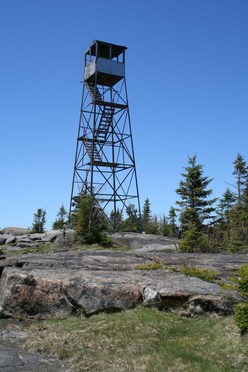
The St. Regis Mountain Fire Observation Station was listed on the National Register of Historic Places in 2005.

Text from Wikipedia, licensed CC BY-SA 4.0.

From the old history books

What they wrote about Santa Clara in 1881

Passages that mention Santa Clara, cut from the printed page as they were published.

Santa Clara College. — Santa Clara College is situated in the town of Santa Clara, which is justly celebrated for the beauty of its surrounding scenery, and the mildness and salubrity of its climate. The Southern Pacific and the South Pacific Coast railroads pass through the town.
History of Santa Clara County, California1881 · page 547Read the page →
Read the text

Santa Clara College. — Santa Clara College is situated in the town of Santa Clara, which is justly celebrated for the beauty of its surrounding scenery, and the mildness and salubrity of its climate. The Southern Pacific and the South Pacific Coast railroads pass through the town.

Text read by machine from the scan; it may contain errors.
Products. — The products of Santa Clara township do not vary from those of other parts of the county. Cereals, in every variety, fruits, vegetables, and tubers, all attain the highest perfection imaginable, while there is easy means of export by the Southern Pacific and South Pacific Coast Railroad…
History of Santa Clara County, California1881 · page 539Read the page →
Read the text

Products. — The products of Santa Clara township do not vary from those of other parts of the county. Cereals, in every variety, fruits, vegetables, and tubers, all attain the highest perfection imaginable, while there is easy means of export by the Southern Pacific and South Pacific Coast Railroads, both of which companies have depots in the town of Santa Clara.

Text read by machine from the scan; it may contain errors.

Scans and text from the Internet Archive. Books published in 1930 or earlier, which are in the public domain.

Timeline

Santa Clara, 1886 to 2004

Woven from the archive, old maps, post office records, the National Register and the people born here.

  1. 19th century
  2. 1886Post officeThe Santa Clara post office opens
  3. 1888Post officeThe Saranac Inn post office opens
  4. 1890Post officeThe Spring Cove post office opens
  5. 1890CensusPopulation peaks at 1,690
  6. 20th century
  7. 1915Post officeThe Spring Cove post office closes
  8. 1918BuiltSt. Regis Mountain Fire Observation Station is built
  9. 1919In the archiveSanta Clara New York USGS topo map 1921
  10. 1921On the mapFirst mapped by the U.S. Geological Survey
  11. 1954Post officeThe Santa Clara post office closes
  12. 1964Post officeThe Saranac Inn post office closes
  13. 21st century
  14. 2004LandmarkEagle Island Camp named a National Historic Landmark
By decade

Santa Clara, decade by decade

One decade in the archive so far: the 1910s. Scroll each row; tap a photo for its story.

1920s–1990snothing yet
Nothing in the archives for these yearsWeddings on Main Street, storms, parades, school pictures, the old store. If it’s in your family album, it belongs here.
Add from your album
On the map

Santa Clara on the map, 1921 to 1964

Every edition of the U.S. Geological Survey’s map of Santa Clara. Tap a year, or press play to watch the town change.

Santa Clara on the 1921 USGS mapSanta Clara on the 1964 USGS map1921Santa Clara sheet · 1:62,500

U.S. Geological Survey historical topographic maps (public domain), via Esri’s collection of the scans. The red ring marks the center of Santa Clara.

On the National Register

6 listings protect 56 historic buildings

The country’s official list of buildings and places worth saving. One is a National Historic Landmark, the highest tier.

places listed
6
National Historic Landmark
1
Eagle Island Camp
historic buildings protected
56
each building in a district counts
first listed
1986
Moss Ledge
All 6 listings

National Park Service, National Register of Historic Places. Photos from Wikimedia Commons, credited on each place’s page.

Famous people

Famous people close to Santa Clara

Nobody well known was born in Santa Clara itself, so here are the best known from just nearby.

See all →
Stories next door

History across the town line

Each neighbor’s History grade, on the same three inputs.

Questions about Santa Clara’s history

What year was Santa Clara founded?

The Santa Clara post office opened in 1886, the earliest record of the town by name (U.S. post office records). Wikidata gives 1888.

What is on the National Register in Santa Clara?

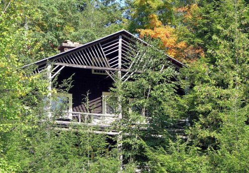
6 listings: 4 buildings, among them the Eagle Island Camp (a National Historic Landmark since 2004) and the Moss Ledge (listed 1986, the first), 1 historic district, the Church of the Ascension Chapel and Rectory, with 4 contributing buildings, and 1 structure. 56 historic buildings in all.

Memory lane

What the archives can’t tell you, neighbors can.

Town Square →
Start a conversation
Sources

Where this page comes from

Founding dates: Wikidata, Wikipedia, the U.S. post office records of Blevins & Helbock (CC0) and the Census. Homes by year built: Census ACS 2020–24. National Register of Historic Places: National Park Service (list of May 22, 2026). Old photos, postcards and papers: Wikimedia Commons, the Library of Congress and other public archives, credited on each item’s page. Maps: U.S. Geological Survey historical topographic maps (via Esri) and Sanborn fire-insurance maps (Library of Congress). History text and census tables: Wikipedia (CC BY-SA 4.0). Places that used to be: USGS Geographic Names Information System (2021). How TownRatings grades history →

From Wikimedia Commons (1), Wikidata (1), the National Register of Historic Places (6), Wikipedia, U.S. Geological Survey historical maps, U.S. Census counts (via Wikipedia), the US Post Offices dataset (Blevins & Helbock), the USGS Geographic Names Information System and old county and town histories (Internet Archive). Archive images are copied here with their credits and licenses, shown on each photo’s page. Refreshed monthly.