Among the most historic 1% of U.S. towns · #28 of 758 in New York. What drives it
13 places in town are on the National Register, among them 2 National Historic Landmarks and three historic districts with 1,213 buildings between them. Below: 5 old photos and papers, maps from 1884 on, and the census since 1860.
On its age, its old homes and the National Register, Rome is among the most historic 1% of U.S. towns, #28 of 758 in New York. All 2 inputs put Rome near the top nationally; its National Register listings ranks highest.
A+
HistoryA character grade: shown, never part of Rome’s overall grade.
New York towns list more on the Register than most of the country (a typical New York town has 12.3 per 10,000 residents, the U.S. 2.4), so Rome’s 387 sits above most of its state (89% of New York towns have fewer) while its 1,231 historic buildings outnumber those of 99% of U.S. towns.
How sure. Graded on two of the three inputs, so a change in either one moves the letter more than it would with three. The pre-1940 share is a Census survey estimate (±3.1 points).
Founding year: our sources. Homes: Census ACS 2020–24. National Register: National Park Service, May 2026 list; each listing counted once (boundary changes and added documentation belong to their listing), and a historic district counts its contributing buildings. How TownRatings grades history →
What stands out about Rome’s past
Read from the archive, the National Register and the record. The page puts what stands out first.
National Park Service, National Register of Historic Places. Photos from Wikimedia Commons, credited on each place’s page.
Places that used to be
Lost post offices, old corners, places now gone and burying grounds
Rome’s post office has been open since 1796. Six other post offices opened and closed inside today’s town.
Rome
1796–today
Oneida
1818–1833
Stanwix
1850–1900
Ridge Mills
1867–1904
Coonrod
1882–1906
Greenway
1886–1902
Lorena
1892–1900
17901910today
Hamlets and corners on the map
Air CityBecks GroveBloomfield ParkCanterbury HillColonial ParkCoonrodGreenwayGreenway CornersHatchs CornersHumastonLiberty GardensLynch TractMohawk GardensPine CrestRidge MillsRiverdaleSeifert CornersStanwixStanwix HeightsTuxedo Mobile Home ParkWright Settlement
Gone or out of use
Canterbury Hill SchoolschoolColumbus Public SchoolschoolDewitt Clinton SchoolschoolEast Rome Public SchoolschoolEast Thomas Street SchoolschoolGriffiss Air Force BasemilitaryJay Street SchoolschoolLiberty Street SchoolschoolMurphy Memorial HospitalhospitalOneida Correctional FacilitybuildingRome State SchoolschoolSaint Mary's Parochial SchoolschoolSchool Number 14schoolSchool Number 4schoolSeventh Day Adventist ChurchchurchSly Hill Pit Number 7mineStanwix SchoolschoolTurin Schoolschool
11cemeteries and burying grounds inside Rome
All SaintsGreenwayHamilHazardHoagLinkOneida CountyRomeSaint John'sSaint MarysSaint Peter's
US Post Offices dataset (Blevins & Helbock, CC0). Places and cemeteries from the USGS Geographic Names Information System (2021).
Rome was founded along an ancient Native American portage path known as the Oneida Carrying Place, Deo-Wain-Sta, or The Great Carrying Place to the Six Nations (Iroquois), or the Haudenosaunee in their language. These names refer to a portage road or path between the Mohawk River to the east, which flows east to the Hudson River, and Wood Creek to the west, which flows into Oneida Lake and, eventually, Lake Ontario via the Oneida and Oswego Rivers. Now located within the modern Rome city limits, this short portage path was the only overland section of a water trade route stretching more than 1,000 miles between Lake Ontario and the lower Hudson. Travelers and traders coming up the Mohawk River from the Hudson had to transfer their cargo and boats and transport them overland between 1 and six miles (depending on the season) to continue west on Wood Creek to Oneida Lake which was drained …
ain ; which Avere further subdivided into governments, under consulars {consulares) or presidents (prcusides), seven in Spain, seventeen in Gaul, and five in Britain — Total, 29. II. The Puefecture of Italy, comprising likewvje three dioceses, those of (1) the city of Rome, (2) Italy, and (3) Africa, and subdivided into thirty governments, under consulars, presidents, correctors (correctores) or dukes (duces), live in Africa, ten in the diocese of the city of Rome, which con'esponded to Southern and Central Italy, and fourteen in the Italian diocese, which comprised North Italy, Rhaetia, Pannonia,
Text read by machine from the scan; it may contain errors.
provocation commenced an aggressive war against Rome's ancient ally, Egypt, and he had plunged also into hostilities with Attains and the Rhodians, both of whom were among the fi'iends of Rome, the former being protected by a treaty (see p. 306). Rome was bound in honor to aid her allies ; and no blame can attach to her for commencino; the Second Macedonian AVar in B.C. 200, and dispatching her troops across the Adriatic. Her conduct of the war was at first
Text read by machine from the scan; it may contain errors.
Scans and text from the Internet Archive. Books published in 1930 or earlier, which are in the public domain.
Timeline
Rome, 1796 to 1962
Woven from the archive, old maps, post office records, the National Register and the people born here.
Nothing in the archives for these yearsWeddings on Main Street, storms, parades, school pictures, the old store. If it’s in your family album, it belongs here.
Every edition of the U.S. Geological Survey’s map of Rome. Tap a year, or press play to watch the town change.
1895Oriskany sheet · 1:62,500
U.S. Geological Survey historical topographic maps (public domain), via Esri’s collection of the scans. The red ring marks the center of Rome.
Every building
Rome, building by building, 1884–1924
Fire insurance maps drew every building, what it was made of and what it was used for, so insurers could price the risk of fire. Pick a year, then a sheet.
Rome is among the most historic 1% of U.S. towns, #28 of 758 in New York. The History grade combines the town’s founding era, the share of homes built before 1940 and its National Register listings. It’s a character grade, so it isn’t part of the overall grade. How it works.
What is on the National Register in Rome?
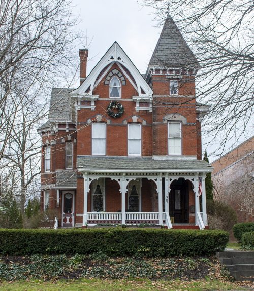
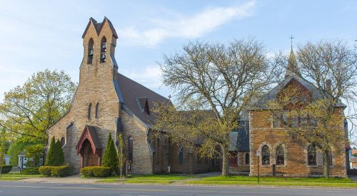
13 listings, 2 of them National Historic Landmarks: 7 buildings, among them the Fort Stanwix National Monument (a National Historic Landmark since 1962), 3 historic districts, the Gansevoort-Bellamy Historic District, the Beeches Historic District, The and the Rome Residential Historic District, with 1,213 contributing buildings, and 3 sites. 1,231 historic buildings in all.
How old are the homes in Rome?
31% of Rome’s homes were built before 1940 (Census estimate, ±3.1 points), against a typical 27% for a New York town; the median home was built in 1955.
Founding dates: Wikidata, Wikipedia, the U.S. post office records of Blevins & Helbock (CC0) and the Census. Homes by year built: Census ACS 2020–24. National Register of Historic Places: National Park Service (list of May 22, 2026). Old photos, postcards and papers: Wikimedia Commons, the Library of Congress and other public archives, credited on each item’s page. Maps: U.S. Geological Survey historical topographic maps (via Esri) and Sanborn fire-insurance maps (Library of Congress). History text and census tables: Wikipedia (CC BY-SA 4.0). Places that used to be: USGS Geographic Names Information System (2021).
From Wikimedia Commons (4), the Library of Congress (1), Wikidata (1), the National Register of Historic Places (13), Wikipedia, Wikidata and Wikipedia for famous people, U.S. Geological Survey historical maps, U.S. Census counts (via Wikipedia), the US Post Offices dataset (Blevins & Helbock), the USGS Geographic Names Information System, Sanborn fire insurance maps (Library of Congress) and old county and town histories (Internet Archive). Archive images are copied here with their credits and licenses, shown on each photo’s page. Refreshed monthly.


 ★ Landmark
 ★ Landmark




 1874


