Guest, Sign inJoin

Post to Montauk

We’ll email a one-tap link to publish your post. No password, and nothing is public until you click it.
Already a member? Sign in
Montauk, New YorkPhoto: Quintin Soloviev · CC BY 4.0
–Not graded
History · Montauk

Montauk’s post office opened in 1883, and 6 of its places are on the National Register

Most of Montauk was built recently: 10% of its homes predate 1940 and the median home dates from 1978. Below: 6 old photos and papers, maps from 1904 on, and the census since 2000.

1883first post office
6on the National Register
10%homes built before 1940
6old photos & papers
2famous people
From Montauk’s archive · credits on each photo
Quick answers

How Montauk began

When was Montauk founded?

1883

The Montauk post office opened in 1883, the earliest record of the town by name.

First census: 3,851 in 20002020 census: 4,318143 years
Founding year: the first Montauk post office (Blevins & Helbock, CC0).The full story ↓

What stands out about Montauk’s past

Read from the archive, the National Register and the record. The page puts what stands out first.

★ What stands out · On the map

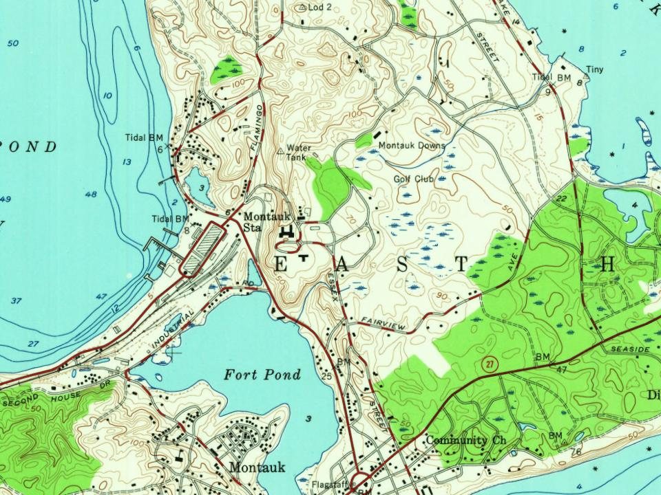
Montauk on the map, 1904 to 1956

Every edition of the U.S. Geological Survey’s map of Montauk. Tap a year, or press play to watch the town change.

Montauk on the 1904 USGS mapMontauk on the 1942 USGS mapMontauk on the 1956 USGS map1904Montauk sheet · 1:62,500

U.S. Geological Survey historical topographic maps (public domain), via Esri’s collection of the scans. The red ring marks the center of Montauk.

On the National Register

6 listings protect 19 historic buildings

The country’s official list of buildings and places worth saving. One is a National Historic Landmark, the highest tier.

places listed
6
National Historic Landmark
1
none yet
historic buildings protected
19
each building in a district counts

National Park Service, National Register of Historic Places. Photos from Wikimedia Commons, credited on each place’s page.

The story

How Montauk came to be

From Wikipedia’s history of Montauk.

Read it all →

Montauk derives its name from the Montaukett tribe, an Algonquian-speaking tribe who lived in the area. In 1614, Dutch explorer Adriaen Block encountered the tribe at Montauk Point, which he named Hoeck van de Visschers, or "Point of the Fishers". Two decades later, in 1637, the Montauketts sided for their own protection with the New England settlers in the Pequot War in Connecticut. In the aftermath the Montauketts were to sell Gardiners Island. In 1648 what would become the Town of Easthampton (first Maidstone) was sold to settlers by the colony of Connecticut and the colony of New Haven while retaining the lands to the east, from the hills rising above where the first fort stood (Napeague, New York) to Montauk Point. The western boundary of today's Hither Hills State Park is also known as the 1648 purchase line.

Text from Wikipedia, licensed CC BY-SA 4.0.

From the old history books

What they wrote about Montauk in 1882

Passages that mention Montauk, cut from the printed page as they were published.

lution. He first settled in Bridgehampton, and kept a tavern on the east corner of the Country road and the Sag Harbor turnpike. In 1776 he was in command of a company appointed to guard the stock on Montauk. After this he joined General Schuyler's army, and served with distinction. After the war h…
...History of Suffolk county, New York1882 · page 40Read the page →
Read the text

lution. He first settled in Bridgehampton, and kept a tavern on the east corner of the Country road and the Sag Harbor turnpike. In 1776 he was in command of a company appointed to guard the stock on Montauk. After this he joined General Schuyler's army, and served with distinction. After the war he moved to Sag Harbor and built a house on the south side of Union street a few rods east of Main street. He was a prominent

Text read by machine from the scan; it may contain errors.
In the spring of 1648 Theophilus Eaton, governor of the colony of New Haven, and Edward Hopkins, governor of Connecticut, obtained a deed for that portion of the town lying west of Montauk. This deed was given by the sachems of Shelter Island, Montauk, Corchaug and Shinecock. The object probably wa…
...History of Suffolk county, New York1882Read the page →
Read the text

In the spring of 1648 Theophilus Eaton, governor of the colony of New Haven, and Edward Hopkins, governor of Connecticut, obtained a deed for that portion of the town lying west of Montauk. This deed was given by the sachems of Shelter Island, Montauk, Corchaug and Shinecock. The object probably was to avoid all trouble that might arise from conflicting claims of ownership. Of this deed the following is a copy. It was re-

Text read by machine from the scan; it may contain errors.

Scans and text from the Internet Archive. Books published in 1930 or earlier, which are in the public domain.

Timeline

Montauk, 1834 to 1995

Woven from the archive, old maps, post office records, the National Register and the people born here.

  1. 19th century
  2. 1834In the archiveUntitled photo
  3. 1898In the archiveMap of Camp Wikoff
  4. 20th century
  5. 1902In the archiveSuffolk County, V. 1, Double Page Plate No. 8 (Map bounded by Part of Town of East Hampto…
  6. 1904On the mapFirst mapped by the U.S. Geological Survey
  7. 1921Born herePerry Belmont Duryea Jr. is born here
  8. 1995Born hereQuincy Davis is born here
By decade

Montauk, decade by decade

3 decades in the archive, from the 1830s to the 1900s. Scroll each row; tap a photo for its story.

1910s–1990snothing yet
Nothing in the archives for these yearsWeddings on Main Street, storms, parades, school pictures, the old store. If it’s in your family album, it belongs here.
Add from your album
Then & now

Stand where they stood

No then-and-now pairs yet. Take a photo from the same spot as an old one and they appear here side by side.

Opname van Woodrow Wilson (staand 2e van links) en zijn familie tijdens zijn zomervakantie in, SFA002001938
Retake this viewOpname van Woodrow Wilson (staand 2e van links) en zijn familie tijdens zijn zomervakantie in, SFA002001938, 1907

Find the spot, match the angle, and add your photo. It becomes the first then-and-now pair on Montauk’s page.

Retake this view · +15
People over time

Montauk, census by census

05001,0001,5002,0002,5003,0003,5004,0004,50020002020Peak: 4,318

Between 3,326 and 4,318 people in every census since 2000.

3 censuses, 2000–2020.

U.S. Census Bureau decennial counts, from the census table on Montauk’s Wikipedia page.

Famous people

2 famous people were born in Montauk

Writers, athletes, leaders and more, ranked by how widely they’re known.

See all →
Help out

Finish Montauk’s story

Most archives stop around 1920. The photos from after that are in family albums, not libraries.

Decades since 1900 with photos
00s10s20s30s40s50s60s70s80s90s
1 of 10 decades. The empty ones are waiting for someone’s album.
Stories next door

History across the town line

Each neighbor’s History grade, on the same three inputs.

Questions about Montauk’s history

What year was Montauk founded?

The Montauk post office opened in 1883, the earliest record of the town by name (U.S. post office records).

Memory lane

What the archives can’t tell you, neighbors can.

Town Square →
Start a conversation
Sources

Where this page comes from

Founding dates: Wikidata, Wikipedia, the U.S. post office records of Blevins & Helbock (CC0) and the Census. Homes by year built: Census ACS 2020–24. National Register of Historic Places: National Park Service (list of May 22, 2026). Old photos, postcards and papers: Wikimedia Commons, the Library of Congress and other public archives, credited on each item’s page. Maps: U.S. Geological Survey historical topographic maps (via Esri) and Sanborn fire-insurance maps (Library of Congress). History text and census tables: Wikipedia (CC BY-SA 4.0). Places that used to be: USGS Geographic Names Information System (2021). How TownRatings grades history →

From Wikimedia Commons (6), Wikipedia, Wikidata and Wikipedia for famous people, U.S. Geological Survey historical maps, U.S. Census counts (via Wikipedia) and old county and town histories (Internet Archive). Archive images are copied here with their credits and licenses, shown on each photo’s page. Refreshed monthly.