


The story
Read it all →How Kortright came to be
From Wikipedia’s history of Kortright.
The West Kortright Presbyterian Church was listed on the National Register of Historic Places in 2002.
Text from Wikipedia, licensed CC BY-SA 4.0.
Each edition grades its towns against each other only.
More historic than 88% of U.S. towns. What drives it
Its Register listings are the McArthur-Martin Hexadecagon Barn, the West Kortright Presbyterian Church and the Bloomville Methodist Epicopal Church. Below: 3 old photos and papers, maps from 1909 on, and the census since 1820.
The Kortright post office opened in 1802, the earliest record of the town by name. Two smaller post offices, North Kortright (1838) and West Kortfight (1859), opened inside today’s town and later closed.
More historic than 88% of U.S. towns, on its age, its old homes and the National Register.
On its age, its old homes and the National Register, Kortright is more historic than 88% of U.S. towns. All 3 inputs are above most U.S. towns; its share of homes from before 1940 ranks highest and its National Register listings lowest.
New York towns list more on the Register than most of the country (a typical New York town has 12.3 per 10,000 residents, the U.S. 2.4), so Kortright’s 30.7 sits near the middle of its state (62% of New York towns have fewer) while its 5 historic buildings outnumber those of 70% of U.S. towns.
Founding year: the first post office (other dates in Quick answers). Homes: Census ACS 2020–24. National Register: National Park Service, May 2026 list; each listing counted once (boundary changes and added documentation belong to their listing), and a historic district counts its contributing buildings. How TownRatings grades history →
Read from the archive, the National Register and the record. The page puts what stands out first.
The first neighbors to add old photos shape how Kortright’s history is told.
Kortright had its own post office from 1802 to 1926. Two other post offices opened and closed inside today’s town.
US Post Offices dataset (Blevins & Helbock, CC0). Places and cemeteries from the USGS Geographic Names Information System (2021).
Every edition of the U.S. Geological Survey’s map of Kortright. Tap a year, or press play to watch the town change.

U.S. Geological Survey historical topographic maps (public domain), via Esri’s collection of the scans. The red ring marks the center of Kortright.
From Wikipedia’s history of Kortright.
The West Kortright Presbyterian Church was listed on the National Register of Historic Places in 2002.
Text from Wikipedia, licensed CC BY-SA 4.0.
Passages that mention Kortright, cut from the printed page as they were published.

In 1770, Lawrence Kortright and his associates, obtained a patent of a large tract of land, principally contained within the limits of the present town of Kortright. The same year the following tracts of land, which, together with those already specified, comprised nearly all the territory of the county, were granted to various associations.
Text read by machine from the scan; it may contain errors.
land, who removed from Albany with his family and located himself below the site of the present flourishing village of Bloomville, and not far from the south corner of the town of Kortright. After the commencement of the Revolution the few whigs (as those persons who dared to disown the king were called,) living in the valley of the Delaware, became, as it were, isolated from even what historians have termed the frontier of New York. They were few in number, and beyond the
Text read by machine from the scan; it may contain errors.Scans and text from the Internet Archive. Books published in 1930 or earlier, which are in the public domain.
Woven from the archive, old maps, post office records, the National Register and the people born here.
 Born hereClark T. Hinman is born here
 Born hereWilliam G. Blakely is born here
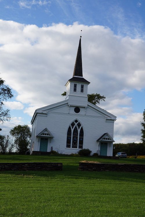 BuiltWest Kortright Presbyterian Church is built
 In the archiveKortright Business Directory; Kortright (Township); Bloomville (Village)
 BuiltMcArthur-Martin Hexadecagon Barn is built
 In the archiveThe Gilchrist Memorial United Presbyterian Church-Kortright, N.Y
 On the mapFirst mapped by the U.S. Geological Survey
2 decades in the archive, from the 1860s to the 1900s. Scroll each row; tap a photo for its story.
No then-and-now pairs yet. Take a photo from the same spot as an old one and they appear here side by side.

Find the spot, match the angle, and add your photo. It becomes the first then-and-now pair on Kortright’s page.
Retake this view · +15The country’s official list of buildings and places worth saving.

National Park Service, National Register of Historic Places. Photos from Wikimedia Commons, credited on each place’s page.
Between 1,073 and 2,873 people in every census since 1820.
21 censuses, 1820–2020.
U.S. Census Bureau decennial counts, from the census table on Kortright’s Wikipedia page.
Writers, athletes, leaders and more, ranked by how widely they’re known.
Each neighbor’s History grade, on the same three inputs.
The Kortright post office opened in 1802, the earliest record of the town by name (U.S. post office records).
Kortright is more historic than 88% of U.S. towns. The History grade combines the town’s founding era, the share of homes built before 1940 and its National Register listings. It’s a character grade, so it isn’t part of the overall grade. How it works.
Three places: the McArthur-Martin Hexadecagon Barn (listed 1984), the West Kortright Presbyterian Church (2002) and the Bloomville Methodist Epicopal Church (2006).
29% of Kortright’s homes were built before 1940 (Census estimate, ±5.9 points), against a typical 27% for a New York town; the median home was built in 1981.
What the archives can’t tell you, neighbors can.
Founding dates: Wikidata, Wikipedia, the U.S. post office records of Blevins & Helbock (CC0) and the Census. Homes by year built: Census ACS 2020–24. National Register of Historic Places: National Park Service (list of May 22, 2026). Old photos, postcards and papers: Wikimedia Commons, the Library of Congress and other public archives, credited on each item’s page. Maps: U.S. Geological Survey historical topographic maps (via Esri) and Sanborn fire-insurance maps (Library of Congress). History text and census tables: Wikipedia (CC BY-SA 4.0). Places that used to be: USGS Geographic Names Information System (2021).
From Wikimedia Commons (1), the Library of Congress (2), Wikidata (1), the National Register of Historic Places (3), Wikipedia, Wikidata and Wikipedia for famous people, U.S. Geological Survey historical maps, U.S. Census counts (via Wikipedia), the US Post Offices dataset (Blevins & Helbock), the USGS Geographic Names Information System and old county and town histories (Internet Archive). Archive images are copied here with their credits and licenses, shown on each photo’s page. Refreshed monthly.
 1908