Lost a third of its people between 1840 and 1910, then more than doubled.
21 censuses, 1820–2020.
U.S. Census Bureau decennial counts, from the census table on Fort Ann’s Wikipedia page.
On the map
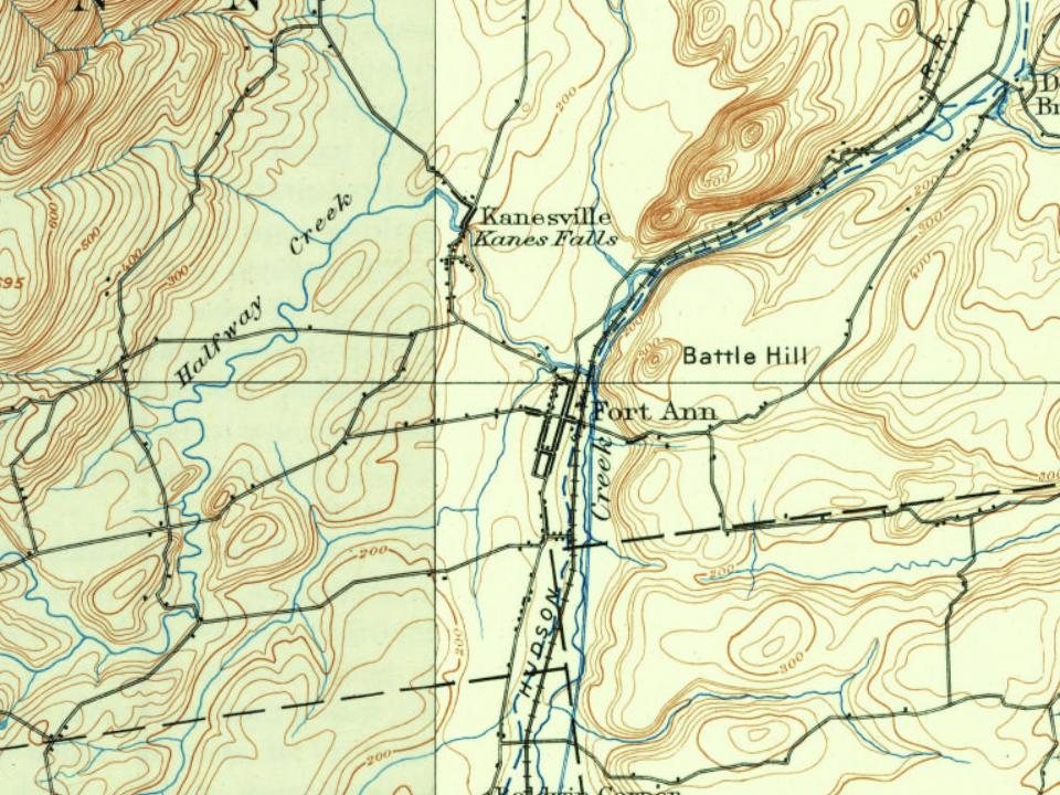
Fort Ann on the map, 1893 to 1944
Every edition of the U.S. Geological Survey’s map of Fort Ann. Tap a year, or press play to watch the town change.
1893Fort Ann sheet · 1:62,500
U.S. Geological Survey historical topographic maps (public domain), via Esri’s collection of the scans. The red ring marks the center of Fort Ann.
Every building
Fort Ann, building by building, 1895–1909
Fire insurance maps drew every building, what it was made of and what it was used for, so insurers could price the risk of fire. Pick a year, then a sheet.
1895Sheet 1 of 1
Edition
Sheets
BrickWoodStone
Sanborn Map Company, via the Library of Congress. Editions published in 1930 or earlier, which are in the public domain.
Fort Ann is located on the historic route linking the French and English colonies.
The area was the site of several forts built by various nations, from a small French fort called "The Pickets" near the southern end of Lake Champlain in 1689, in the northwestern area of the town, to a series of forts (including "Fort Schuyler" and "Queen's Fort") closer to where the village of Fort Ann stands today. The first of these was likely the Stone Fort, built by Englishman Fitz John Winthrop in 1692.
The village of Fort Ann has a depot on the Delaware & Hudson Railroad; the Champlain Canal passes through it, and a daily stage connects it with Glens Falls. The postoffice was established in 1800, and George Clark was the first postmaster. The business carried on is mostly commercial, but there is a knitting and woolen mill conducted by Edgar Wall.
Text read by machine from the scan; it may contain errors.
Fort Ann was formed, as the town of Westfield, March 23, 1786, and at that time included Putnam, Dresden and Hartford, as well as its present territory. Hartford was set off in 1793, and Putnam and Dresden, as one town, in 1806. In 1808 the name of Westfield was changed to Fort Ann, in memory of the old fort at the village.
Text read by machine from the scan; it may contain errors.
Scans and text from the Internet Archive. Books published in 1930 or earlier, which are in the public domain.
Timeline
Fort Ann, 1757 to 2000
Woven from the archive, old maps, post office records, the National Register and the people born here.
Nothing in the archives for these yearsWeddings on Main Street, storms, parades, school pictures, the old store. If it’s in your family album, it belongs here.
Founding dates: Wikidata, Wikipedia, the U.S. post office records of Blevins & Helbock (CC0) and the Census. Homes by year built: Census ACS 2020–24. National Register of Historic Places: National Park Service (list of May 22, 2026). Old photos, postcards and papers: Wikimedia Commons, the Library of Congress and other public archives, credited on each item’s page. Maps: U.S. Geological Survey historical topographic maps (via Esri) and Sanborn fire-insurance maps (Library of Congress). History text and census tables: Wikipedia (CC BY-SA 4.0). Places that used to be: USGS Geographic Names Information System (2021). How TownRatings grades history →
From Wikimedia Commons (16), the Library of Congress (1), Wikidata (1), Wikipedia, Wikidata and Wikipedia for famous people, U.S. Geological Survey historical maps, U.S. Census counts (via Wikipedia), Sanborn fire insurance maps (Library of Congress) and old county and town histories (Internet Archive). Archive images are copied here with their credits and licenses, shown on each photo’s page. Refreshed monthly.






 1895
 2024
 2024
 2024
 2024
 2024
 2024
 2024
 2024
 2024
 2011
 2009
 2008

