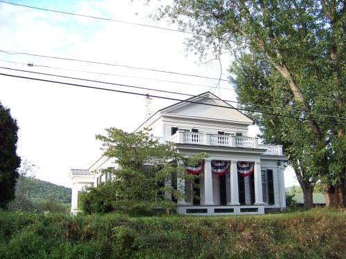
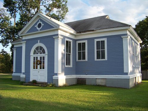
Its Register listings are the Dr. Hovey Everett House, the Chemung District School No. 10 and the Riverside Cemetery. Below: 1 old photo or paper, maps from 1986 on, and the census since 1790.
Founding year: Wikidata. First post office: 1800.The full story ↓
History grade
What drives Chemung’s History grade
On its age, its old homes and the National Register, Chemung is more historic than 79% of U.S. towns. All 3 inputs are above most U.S. towns; its age ranks highest and its share of homes from before 1940 lowest.
A−
HistoryA character grade: shown, never part of Chemung’s overall grade.
New York towns list more on the Register than most of the country (a typical New York town has 12.3 per 10,000 residents, the U.S. 2.4), so Chemung’s 21.2 sits near the middle of its state (57% of New York towns have fewer) while its 5 historic buildings outnumber those of 70% of U.S. towns.
How sure. Graded on any two of the three inputs instead, the letter would range from B+ to A−. The pre-1940 share is a Census survey estimate (±5.9 points). Two sources give 1786.
Founding year: Wikidata (other dates in Quick answers). Homes: Census ACS 2020–24. National Register: National Park Service, May 2026 list; each listing counted once (boundary changes and added documentation belong to their listing), and a historic district counts its contributing buildings. How TownRatings grades history →
What stands out about Chemung’s past
Read from the archive, the National Register and the record. The page puts what stands out first.
The region was destroyed by the Sullivan Expedition on August 13, 1779, which fought at the Battle of Newtown, just west of the current town of Chemung.
The town of Chemung was established in 1788 as the original town in the region. Chemung lost territory when Tioga County was formed in 1791. The town of Newtown (now the town of Elmira) was taken from Chemung in 1792. Chemung was incorporated in 1788 into Montgomery County, at the time of that town's formation. (Chemung County was not created until 1836.) Subsequently, the town of Chemung lost more territory to form all or parts of Erin (1822), Baldwin (1856), and Ashland (1867).
Passages that mention Chemung, cut from the printed page as they were published.
History of Tioga, Chemung, Tompkins and Schuyler counties, New York1879 · page 333Read the page →
Read the text
By an act of the Legislature, passed May 4, 1869, and amended May 14, 1875, authorizing the construction and maintenance of a free bridge over the Chemung River, in the town of Chemung, Mijamin Griswold, Jesse Owens, and Henry Baker, of the town of Chemung, were appointed bridge commissioners to locate and construct a bridge, at a cost not exceeding $18,000, and to issue bonds which should be binding on the town. The commissioners, after
Text read by machine from the scan; it may contain errors.
History of Tioga, Chemung, Tompkins and Schuyler counties, New York1879 · page 307Read the page →
Read the text
THE WELLSBURG BAPTIST CHURCH, known at different times by the names of Chemung, Elmira and Chemung, Southport and Chemung, and Wellsburg, was organized on the 2d day of September, 1789. The few hardy pioneers in the then town of Chemung constituted themselves a gospel church, adopting a covenant and regulations, as expressed by themselves in the following language : “ Whereas , We, a number of members belonging to different
Text read by machine from the scan; it may contain errors.
An outline history of Tioga and Bradford counties in Pennsylvania, Chemung, Steuben, Tioga, Tompkins and Schuyler in New York1885 · page 114Read the page →
Read the text
The county of Chemung is bounded on the north by the counties of Schuyler and Tompkins, on the east hj Tioga county, N. Y., on the south by the Pennsylvania state line, and on the wesi by Steuben, The Chemung river enters the county from the west, in the town of Big Flats, about eight miles north of the Pennsylvania state line, and running easterly and southeasterly through Big Flats enters the town of Elmira, and passes through the center of the city of Elmira, thence southerly through the town of Southport, and along the eastern line of Ashland, enters and runs through the
Text read by machine from the scan; it may contain errors.
An outline history of Tioga and Bradford counties in Pennsylvania, Chemung, Steuben, Tioga, Tompkins and Schuyler in New York1885 · page 208Read the page →
Read the text
The county of Tioga is bounded on the north by the counties of Tompkins and Cortland, on the east by Broome, on the south by the Pennsylvania state line, and on the west by the county of Chemung, The principal stream of the county is the North East Branch of the Susquehanna, which enters the county from Broome county, in the town of Owego, the south eastern township of Tioga county, and flowing westerly through to the village of Owego, thence south easterly through the township of Nichols, passes out of the county into Pennsylvania on the town line of Barton and
Text read by machine from the scan; it may contain errors.
Scans and text from the Internet Archive. Books published in 1930 or earlier, which are in the public domain.
Timeline
Chemung, 1786 to 1986
Woven from the archive, old maps, post office records, the National Register and the people born here.
In 1786, according to Wikidata. Chemung’s post office opened in 1800, and the first U.S. census counted 2,391 people here in 1790.
How does Chemung rank for history?
Chemung is more historic than 79% of U.S. towns. The History grade combines the town’s founding era, the share of homes built before 1940 and its National Register listings. It’s a character grade, so it isn’t part of the overall grade. How it works.
What is on the National Register in Chemung?
Three places: the Dr. Hovey Everett House (listed 2007), the Chemung District School No. 10 (2008) and the Riverside Cemetery (2012).
How old are the homes in Chemung?
17% of Chemung’s homes were built before 1940 (Census estimate, ±5.9 points), against a typical 27% for a New York town; the median home was built in 1982.
Founding dates: Wikidata, Wikipedia, the U.S. post office records of Blevins & Helbock (CC0) and the Census. Homes by year built: Census ACS 2020–24. National Register of Historic Places: National Park Service (list of May 22, 2026). Old photos, postcards and papers: Wikimedia Commons, the Library of Congress and other public archives, credited on each item’s page. Maps: U.S. Geological Survey historical topographic maps (via Esri) and Sanborn fire-insurance maps (Library of Congress). History text and census tables: Wikipedia (CC BY-SA 4.0). Places that used to be: USGS Geographic Names Information System (2021).
From Wikimedia Commons (4), Wikidata (1), the National Register of Historic Places (3), Wikipedia, Wikidata and Wikipedia for famous people, U.S. Geological Survey historical maps, U.S. Census counts (via Wikipedia), the US Post Offices dataset (Blevins & Helbock), the USGS Geographic Names Information System and old county and town histories (Internet Archive). Archive images are copied here with their credits and licenses, shown on each photo’s page. Refreshed monthly.





 2013
 2008
 2008