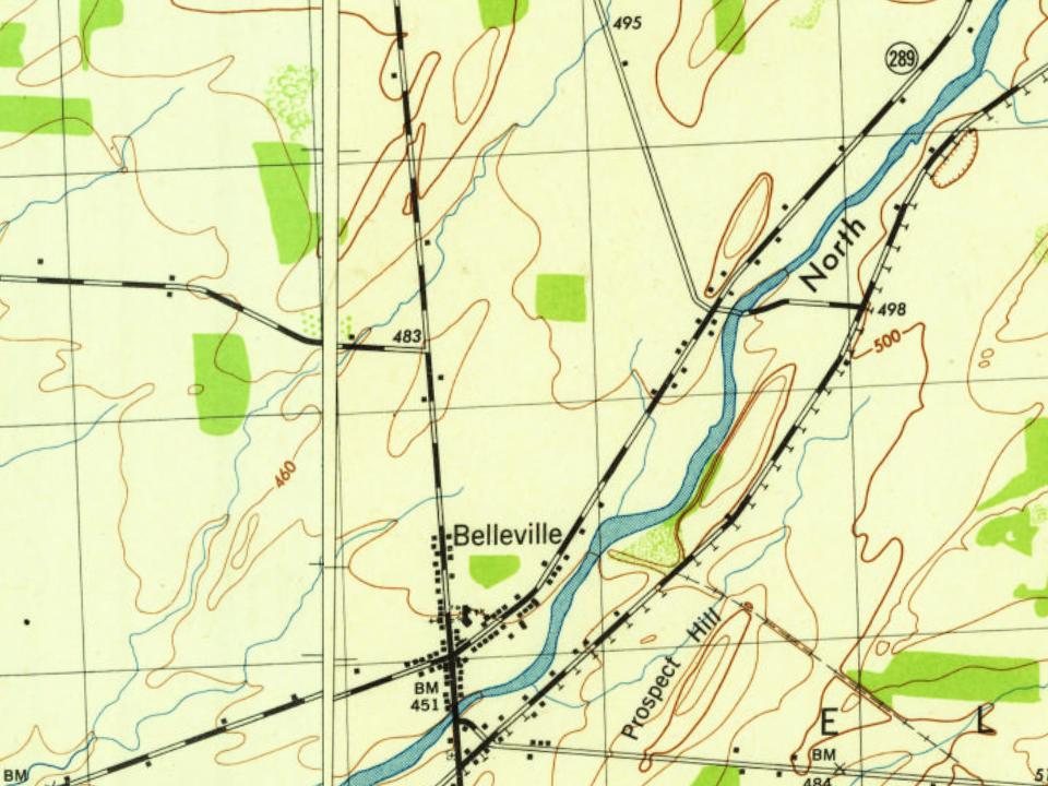
Every edition of the U.S. Geological Survey’s map of Belleville. Tap a year, or press play to watch the town change.
1893Sackets Harbor sheet · 1:62,500
U.S. Geological Survey historical topographic maps (public domain), via Esri’s collection of the scans. The red ring marks the center of Belleville.
The story so far
Belleville, in brief
Wikipedia doesn’t have a history of Belleville yet. The photos, dates and memories neighbors add here are how it gets written.
Belleville is a hamlet and census-designated place (CDP) in the town of Ellisburg, Jefferson County, New York, United States. As of the 2020 census, Belleville had a population of 233. It was an incorporated village from 1860 to 1930.
Its first post office opened in 1827. Between the 2010 and 2020 censuses its population grew from 226 to 233 (+3%).
Intro from Wikipedia. Population: U.S. Census Bureau.
From the old history books
What they wrote about Belleville, 1854–1878
Passages that mention Belleville, cut from the printed page as they were published.
Sketches of the country on the northern route from Belleville, Illinois, to the city of New York, and back by the Ohio Valley1854 · page 17Read the page →
Read the text
All the blessings of civilized society exist here, as they do in the Eastern States, so that the operators in the factories here, would enjoy as good society as they do in the old States, and the fuel, provisions and living are so much cheaper in Belleville than in the old Country, that the difference would be considerable. The population of Belleville may be considered orderly, decent, and moral, and have always had the good sense to reject all spee'.es of fanatacism. They abhor the modern absurdity of "Spiritual
Text read by machine from the scan; it may contain errors.
A history of Jefferson County in the state of New York1854 · page 408Read the page →
Read the text
and the benefits of association scarcely extended to the more remote sections of the county. This society has held one fair annually since its organization, viz: at Ellis Village in 1849 and 1850; at Belleville in 1851; at Ellis Village in 1852, and at Belleville in 1853. By a resolution of January S, 1853, the citizens of Adams and Henderson were allowed to compete for premiums, but all meetings were to be held in Ellisburgh, and on the 10th of March,
Text read by machine from the scan; it may contain errors.
History of Jefferson County, New York1878 · page 106Read the page →
Read the text
board of education of the city of Watertown. The " Union Literary Society," at Belleville, in the town of Ellisburg, was incorporated in April, 1826, and is still in operation. The "Orleans Academy" was put in operation in 1851, and continued for many years. The " Brownville Female Seminary" was opened in 1849, and continued in operation until April 5, 1855, when an act was passed allowing it to sell its property and close up.
Text read by machine from the scan; it may contain errors.
History of Jefferson County, New York1878 · page 377Read the page →
Read the text
The house in which the family lived is still standing, the first house north of the iron bridge, and is still owned by the subject of this sketch. With the exception of three years, in which the family lived in Belleville, they lived in Woodville. The father died there Sept. 24, 1858, the mother having died in Belleville June 18 of the same year.
Text read by machine from the scan; it may contain errors.
Scans and text from the Internet Archive. Books published in 1930 or earlier, which are in the public domain.
Timeline
Belleville, 1833 to 1893
Woven from the archive, old maps, post office records, the National Register and the people born here.
Founding dates: Wikidata, Wikipedia, the U.S. post office records of Blevins & Helbock (CC0) and the Census. Homes by year built: Census ACS 2020–24. National Register of Historic Places: National Park Service (list of May 22, 2026). Old photos, postcards and papers: Wikimedia Commons, the Library of Congress and other public archives, credited on each item’s page. Maps: U.S. Geological Survey historical topographic maps (via Esri) and Sanborn fire-insurance maps (Library of Congress). History text and census tables: Wikipedia (CC BY-SA 4.0). Places that used to be: USGS Geographic Names Information System (2021). How TownRatings grades history →
From Wikimedia Commons (1), Wikidata and Wikipedia for famous people, U.S. Geological Survey historical maps and old county and town histories (Internet Archive). Archive images are copied here with their credits and licenses, shown on each photo’s page. Refreshed monthly.