Carson City was first counted by the census in 1850, and 43 of its places are on the National Register
More historic than 52% of U.S. towns · #4 of 42 in Nevada. What drives it
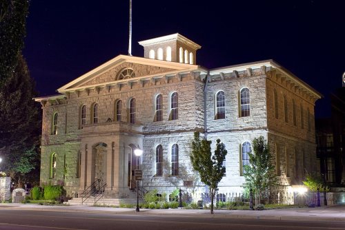
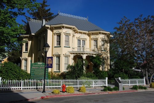
Most of Carson City was built recently: 2% of its homes predate 1940 and the median home dates from 1981. 43 places in town are on the National Register, among them the McKeen Motor Car #70, a National Historic Landmark, and three historic districts with 320 buildings between them. Below: 4 old photos and papers, maps from 1885 on, and the census since 1850.
From Carson City’s archive · credits on each photo
Quick answers
How Carson City began
When was Carson City founded?
1850
Carson City first appears in the census in 1850. Four smaller post offices, Empire City (1866), Lake View (1881) and Empire (1895), opened inside today’s town and later closed.
First census: 714 in 18502020 census: 58,639176 years
How historic is Carson City?
B−
More historic than 52% of U.S. towns, on its age, its old homes and the National Register.
On its age, its old homes and the National Register, Carson City is more historic than 52% of U.S. towns, #4 of 42 in Nevada. Its National Register listings hold the grade up; its share of homes from before 1940 pulls it down.
B−
HistoryA character grade: shown, never part of Carson City’s overall grade.
Few Nevada towns list much on the Register (a typical Nevada town has 0.0 per 10,000 residents, the U.S. 2.4), so Carson City’s 109 sits above most of its state (94% of Nevada towns have fewer) while its 639 historic buildings outnumber those of 98% of U.S. towns.
How sure. Graded on any two of the three inputs instead, the letter would range from C− to B+. The pre-1940 share (±0.7 points) is firm at this size.
Founding year: the first census (other dates in Quick answers). Homes: Census ACS 2020–24. National Register: National Park Service, May 2026 list; each listing counted once (boundary changes and added documentation belong to their listing), and a historic district counts its contributing buildings. How TownRatings grades history →
What stands out about Carson City’s past
Read from the archive, the National Register and the record. The page puts what stands out first.
National Park Service, National Register of Historic Places. Photos from Wikimedia Commons, credited on each place’s page.
Places that used to be
Lost post offices, old corners, places now gone and burying grounds
Carson City’s post office has been open since 1858. Four other post offices opened and closed inside today’s town.
Carson City
1858–today
Empire City
1866–1895
Lake View
1881–1894
Empire
1895–1912
Stewart
1905–1974
18501940today
Hamlets and corners on the map
BrunswickCarson Hot SpringsEagle StationEmpireFiddlers GreenLakeviewMill Creek SettlementNew EmpirePinyon HillsStewart
Gone or out of use
Alex Eske MinemineAshs SawmilllocaleAthens MinemineBaldwin and Company MilllocaleBessemer MinemineBidwell MinemineBlue Canyon MilllocaleBrowns RanchlocaleBunker Hill MinemineCamp NyelocaleCapitol MinemineCarson Black Lead MinemineCarson City Post Officepost officeCarson City StationlocaleCarson MinemineCarson Rest ArealocaleCinderlite MinemineClear Creek Campgroundlocale
2cemeteries and burying grounds inside Carson City
EmpireLone Mountain
US Post Offices dataset (Blevins & Helbock, CC0). Places and cemeteries from the USGS Geographic Names Information System (2021).
The Washoe people have inhabited the valley and surrounding areas for about 6,000 years.
The first European Americans to arrive in what is now known as Eagle Valley were John C. Frémont and his exploration party in January 1843. Fremont named the river flowing through the valley Carson River in honor of Kit Carson (1809–1868), the mountain man, explorer, and scout he had hired for his expedition. Later, settlers named the area Washoe in reference to the indigenous people.
Every edition of the U.S. Geological Survey’s map of Carson City. Tap a year, or press play to watch the town change.
1956Carson City sheet · 1:62,500
U.S. Geological Survey historical topographic maps (public domain), via Esri’s collection of the scans. The red ring marks the center of Carson City.
Every building
Carson City, building by building, 1885–1907
Fire insurance maps drew every building, what it was made of and what it was used for, so insurers could price the risk of fire. Pick a year, then a sheet.
The Carson City post office opened in 1850, the earliest record of the town by name (U.S. post office records). Wikidata gives 1858.
How does Carson City rank for history?
Carson City is more historic than 52% of U.S. towns, #4 of 42 in Nevada. The History grade combines the town’s founding era, the share of homes built before 1940 and its National Register listings. It’s a character grade, so it isn’t part of the overall grade. How it works.
What is on the National Register in Carson City?
43 listings: 35 buildings, 3 historic districts, the Stewart Indian School, the West Side Historic District and the Nevada State Prison, with 320 contributing buildings, and 5 structures. 639 historic buildings in all.
How old are the homes in Carson City?
2% of Carson City’s homes were built before 1940 (Census estimate), against a typical 0.3% for a Nevada town; the median home was built in 1981.
Founding dates: Wikidata, Wikipedia, the U.S. post office records of Blevins & Helbock (CC0) and the Census. Homes by year built: Census ACS 2020–24. National Register of Historic Places: National Park Service (list of May 22, 2026). Old photos, postcards and papers: Wikimedia Commons, the Library of Congress and other public archives, credited on each item’s page. Maps: U.S. Geological Survey historical topographic maps (via Esri) and Sanborn fire-insurance maps (Library of Congress). History text and census tables: Wikipedia (CC BY-SA 4.0). Places that used to be: USGS Geographic Names Information System (2021).
From Wikimedia Commons (4), Wikidata (1), the National Register of Historic Places (43), Wikipedia, Wikidata and Wikipedia for famous people, U.S. Geological Survey historical maps, U.S. Census counts (via Wikipedia), the US Post Offices dataset (Blevins & Helbock), the USGS Geographic Names Information System and Sanborn fire insurance maps (Library of Congress). Archive images are copied here with their credits and licenses, shown on each photo’s page. Refreshed monthly.


 ★ Landmark




 1866
 1866


