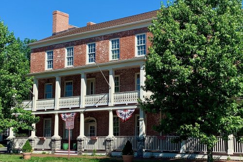
Its Register listings are the Chester House Inn and the First Congregational Church. Below: 11 old photos and papers, maps from 1886 on, and the census since 1880.
Founding year: the first Chester post office (Blevins & Helbock, CC0).The full story ↓
History grade
What drives Chester’s History grade
On its age, its old homes and the National Register, Chester is more historic than 81% of U.S. towns. All 3 inputs are above most U.S. towns; its age ranks highest and its National Register listings lowest.
A−
HistoryA character grade: shown, never part of Chester’s overall grade.
New Jersey towns list more on the Register than most of the country (a typical New Jersey town has 3.7 per 10,000 residents, the U.S. 2.4), so Chester’s 13.2 sits above most of its state (71% of New Jersey towns have fewer) while its 2 listings outnumber those of 60% of U.S. towns.
How sure. Graded on any two of the three inputs instead, the letter would range from B+ to A−. The pre-1940 share is a Census survey estimate (±5.0 points). The founding year is the first post office, not a stated founding date.
Founding year: the first post office (other dates in Quick answers). Homes: Census ACS 2020–24. National Register: National Park Service, May 2026 list; each listing counted once (boundary changes and added documentation belong to their listing), and a historic district counts its contributing buildings. How TownRatings grades history →
What stands out about Chester’s past
Read from the archive, the National Register and the record. The page puts what stands out first.
Every edition of the U.S. Geological Survey’s map of Chester. Tap a year, or press play to watch the town change.
1888Lake Hopatcong sheet · 1:62,500
U.S. Geological Survey historical topographic maps (public domain), via Esri’s collection of the scans. The red ring marks the center of Chester.
Every building
Chester, building by building, 1886–1912
Fire insurance maps drew every building, what it was made of and what it was used for, so insurers could price the risk of fire. Pick a year, then a sheet.
1886Sheet 1 of 1
Edition
Sheets
BrickWoodStone
Sanborn Map Company, via the Library of Congress. Editions published in 1930 or earlier, which are in the public domain.
Timeline
Chester, 1808 to 2002
Woven from the archive, old maps, post office records, the National Register and the people born here.
Chester Township was established as a separate political entity on April 1, 1799, including the area of both the Township and the downtown settlement which came to be the borough. The Borough of Chester was incorporated by an act of the New Jersey Legislature on April 3, 1930, based on the results of a referendum held on April 25, 1930, and is today a separate municipality surrounded entirely by Chester Township.
The borough's name is derived from the township, which was named for Cheshire in England.
Passages that mention Chester, cut from the printed page as they were published.
History of Morris County, New Jersey1882 · page 19Read the page →
Read the text
now called Ralstonville, west of Mendham, and the actual settlement of the Mendham neighborhood probably soon followed. In the same year the site of the village of Chester is said to have been laid out in lots for settlement. Thus from opposite sides, under different auspices and by men of different nationalities, the work of subduing the wilderness was begun. The energy and perseverance
Text read by machine from the scan; it may contain errors.
A history of Morris County, New Jersey1914 · page 168Read the page →
Read the text
with merchandise for the dealers of these counties. In 1832 the Morris canal was finished, and in 1853 the Morris and Essex railroad was completed to Hackettstown. The Chester railroad, a branch of the M. & E. railroad, leaves the main line near Wharton, and passes through the eastern part of the township, Kenvil and Succasunna being stations on that line, which was opened for traffic in January, 1870. The High Bridge Branch of the Central Railroad of New Jersey was completed to McCainville in July, 1876, and extended to Wharton (formerly Port Oram) in 1878, a further exten-
Text read by machine from the scan; it may contain errors.
A history of Morris County, New Jersey1914 · page 178Read the page →
Read the text
The village of Chester, originally known as Black River, was laid out in lots by General Horn, who purchased the land from Zephaniah Drake. When the first settlers came there were no roads, travel being by bridle paths, and as late as 1768, Rev. William Woodhull made his way into the parish, of which he became pastor, on horseback with his wife and child riding behind him. The first spring wagon was brought in by James Topping, who died in 1874, aged ninety-four years. The proprietor of the first line of stages was Zephaniah Drake, who also erected the first brick building in
Text read by machine from the scan; it may contain errors.
History of Morris County, New Jersey1882 · page 60Read the page →
Read the text
Port Oram is that place in the county best adapted for the manufacture of iron. The Mojris Canal and the Morris and Essex Railroad pass through the place and the Mount Hope and Chester branches terminate here. In addition to these within the last year the High Bridgebranch of the Central of New Jersey, and the Dover and Rockaway road, connecting with the Hibernia Railroad, have made this their junction. It is a place which has
Text read by machine from the scan; it may contain errors.
Scans and text from the Internet Archive. Books published in 1930 or earlier, which are in the public domain.
By decade
Chester, decade by decade
2 decades in the archive, from the 1840s to the 1910s. Scroll each row; tap a photo for its story.
Nothing in the archives for these yearsWeddings on Main Street, storms, parades, school pictures, the old store. If it’s in your family album, it belongs here.
The Chester post office opened in 1808, the earliest record of the town by name (U.S. post office records).
How does Chester rank for history?
Chester is more historic than 81% of U.S. towns. The History grade combines the town’s founding era, the share of homes built before 1940 and its National Register listings. It’s a character grade, so it isn’t part of the overall grade. How it works.
What is on the National Register in Chester?
Two places: the Chester House Inn (listed 1974) and the First Congregational Church (1977).
How old are the homes in Chester?
18% of Chester’s homes were built before 1940 (Census estimate, ±5.0 points), against a typical 15% for a New Jersey town; the median home was built in 1971.
Founding dates: Wikidata, Wikipedia, the U.S. post office records of Blevins & Helbock (CC0) and the Census. Homes by year built: Census ACS 2020–24. National Register of Historic Places: National Park Service (list of May 22, 2026). Old photos, postcards and papers: Wikimedia Commons, the Library of Congress and other public archives, credited on each item’s page. Maps: U.S. Geological Survey historical topographic maps (via Esri) and Sanborn fire-insurance maps (Library of Congress). History text and census tables: Wikipedia (CC BY-SA 4.0). Places that used to be: USGS Geographic Names Information System (2021).
From Wikimedia Commons (6), the Library of Congress (10), Wikidata (2), the National Register of Historic Places (2), Wikipedia, Wikidata and Wikipedia for famous people, U.S. Geological Survey historical maps, U.S. Census counts (via Wikipedia), the US Post Offices dataset (Blevins & Helbock), the USGS Geographic Names Information System, Sanborn fire insurance maps (Library of Congress) and old county and town histories (Internet Archive). Archive images are copied here with their credits and licenses, shown on each photo’s page. Refreshed monthly.




 1915
 1915
 1915
 1915
 1915
 1915
 1916
 1916
 1916
 2025
 2025
 2020
 2008
 2007
