Pittsburg dates to 1840, and 1 of its places is on the National Register
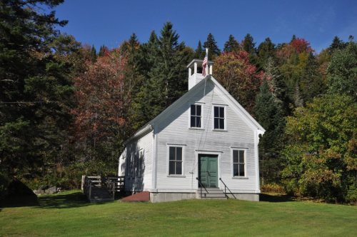
Most of Pittsburg was built recently: 8% of its homes predate 1940 and the median home dates from 1983. Its Register listing is the Indian Stream Schoolhouse. Below: maps from 1989 on and the census since 1840.
Peaked at 1,311 in 1920; 800 people lived here in 2020.
19 censuses, 1840–2020.
U.S. Census Bureau decennial counts, from the census table on Pittsburg’s Wikipedia page.
Places that used to be
Lost post offices, old corners and places now gone
Pittsburg’s post office has been open since 1851. Another post office, Indian Stream, opened and closed inside today’s town.
Indian Stream
1835–1839
Pittsburg
1851–today
18301930today
Hamlets and corners on the map
Happy CornerIdlewildeThe Glen
Gone or out of use
Camp Number 31localeCamp Number 32localeCamp Number 36localeCurrier CamplocaleFalkenham CamplocaleGreeley CamplocaleHalls Stream SchoolschoolIndian Stream SchoolschoolKim Day DamdamKlondyke CamplocaleMoose Bog CamplocaleVarney CamplocaleVarney CamplocaleWheeler Schoolschool
US Post Offices dataset (Blevins & Helbock, CC0). Places and cemeteries from the USGS Geographic Names Information System (2021).
Pittsburg derives its name from William Pitt, Prime Minister of Great Britain. Prior to its incorporation in 1840, the area was settled c. 1810 and known as the Territory of Indian Stream. It had the unique distinction of having been its own microstate briefly during the 1830s, called the Republic of Indian Stream, due to an ambiguous boundary between the United States and Canada.
The Indian Stream Schoolhouse on Tabor Road, which dates to 1897, is listed in both the National Register of Historic Places and the New Hampshire State Register of Historic Places; the town hall on Main Street, which dates to 1883, is listed in the State Register.
Passages that mention Pittsburg, cut from the printed page as they were published.
History of Coos County, New Hampshire .1888 · page 720Read the page →
Read the text
enhanced value of real estate; and, although the easterly portion of the town is at a considerable distance from the nearest railroad station, yet, with the certain prospect of an early construction of a branch road to Connecticut lake, Pittsburg, with its vast undeveloped resources of forests, minerals, abundant water-power, extensive areas of uncleared lands well adapted to agricultural purposes, and already opened to settlement, unrivalled attractions as a place of summer resort for tourists, its abundance of cool, refreshing, spring water, its altitude and healthful climate
Text read by machine from the scan; it may contain errors.
History of Coos County, New Hampshire .1888 · page 138Read the page →
Read the text
point on the railroad being North Stratford, thirteen miles away. In the legislature of 1883 a charter for a railroad was obtained from Stratford to Pittsburg, and in April and May, 1887, a subscription for a narrow gauge railroad was raised, stock to the amount of forty-five thousand dollars being taken. The corporation was organized with J. H. Dudley, president; Albert Barker, clerk; and Sherburn R. Merrill, treasurer; and about $11,000 paid into the stock subscription, when Frank Jones, Charles A. Sinclair and George Van Dyke offered to build a standard gauge road
Text read by machine from the scan; it may contain errors.
Scans and text from the Internet Archive. Books published in 1930 or earlier, which are in the public domain.
Timeline
Pittsburg, 1835 to 1989
Woven from the archive, old maps, post office records, the National Register and the people born here.
Founding dates: Wikidata, Wikipedia, the U.S. post office records of Blevins & Helbock (CC0) and the Census. Homes by year built: Census ACS 2020–24. National Register of Historic Places: National Park Service (list of May 22, 2026). Old photos, postcards and papers: Wikimedia Commons, the Library of Congress and other public archives, credited on each item’s page. Maps: U.S. Geological Survey historical topographic maps (via Esri) and Sanborn fire-insurance maps (Library of Congress). History text and census tables: Wikipedia (CC BY-SA 4.0). Places that used to be: USGS Geographic Names Information System (2021). How TownRatings grades history →
From Wikimedia Commons (13), Wikidata (1), the National Register of Historic Places (1), Wikipedia, Wikidata and Wikipedia for famous people, U.S. Geological Survey historical maps, U.S. Census counts (via Wikipedia), the US Post Offices dataset (Blevins & Helbock), the USGS Geographic Names Information System and old county and town histories (Internet Archive). Archive images are copied here with their credits and licenses, shown on each photo’s page. Refreshed monthly.



 2025
 2016
 2016
 2016
 2014
 2013
 2013
 2013
 2013
 2013
 2013
 2013
 2010
