Guest, Sign inJoin

Post to Lyman

We’ll email a one-tap link to publish your post. No password, and nothing is public until you click it.
Already a member? Sign in
–Not graded
History · Lyman

Lyman dates to 1761, and 19% of its homes were built before 1940

Below: 1 old photo or paper, maps from 1986 on, and the census since 1790.

1761founded
0on the National Register
19%homes built before 1940
1old photo or paper
2famous people
Photo: Ascended Dreamer · CC BY-SA 4.0
Quick answers

How Lyman began

When was Lyman founded?

1761

Lyman dates its founding to 1761 (Wikidata). It appears in the first U.S. census, 1790.

First census: 202 in 17902020 census: 585265 years
Founding year: Wikidata. First post office: 1808.The full story ↓

What stands out about Lyman’s past

Read from the archive, the National Register and the record. The page puts what stands out first.

★ What stands out · Help out

Start Lyman’s collection

The first neighbors to add old photos shape how Lyman’s history is told.

Decades since 1900 with photos
00s10s20s30s40s50s60s70s80s90s
0 of 10 decades. The empty ones are waiting for someone’s album.
People over time

Lyman, census by census

02004006008001,0001,2001,4001,600180018501900195020001,496 in 1840Low: 201

Lost two-thirds of its people between 1840 and 1960, then more than doubled.

24 censuses, 1790–2020.

U.S. Census Bureau decennial counts, from the census table on Lyman’s Wikipedia page.

Timeline

Lyman, 1761 to 1986

Woven from the archive, old maps, post office records, the National Register and the people born here.

  1. 18th century
  2. 1761
    FoundingLyman is established
  3. 19th century
  4. 1808Post officeThe Lyman post office opens
  5. 1813Born hereAmasa Lyman is born here
  6. 1840CensusPopulation peaks at 1,496
  7. 1877Born hereBliss Knapp is born here
  8. 20th century
  9. 1905Post officeThe Lyman post office closes
  10. 1986On the mapFirst mapped by the U.S. Geological Survey
The story

How Lyman came to be

From Wikipedia’s history of Lyman.

Read it all →

Lyman, along with Grantham, Lisbon, and eleven Vermont towns, was granted as compensation to General Phineas Lyman, a commander in the French and Indian War. According to the county gazetteer, "It was granted to Daniel Lyman and sixty-three others, November 10, 1761, its name being derived from the fact that eleven of the grantees bore the name of Lyman. The grantees failed to comply with the requirements of their charter, and thus forfeited their grant, but an extension of time was granted them July 20, 1769." Until 1854, Lyman included the land which is now Monroe, New Hampshire, but it was split due to the difficulty in traversing Gardner Mountain which formerly bisected the town. In 1880 it had a population of 665.

Text from Wikipedia, licensed CC BY-SA 4.0.

From the old history books

What they wrote about Lyman in 1903

Passages that mention Lyman, cut from the printed page as they were published.

Grafton Ss 1 one of the Justis of the peace within and for the County of Grafton Humbly Shue The Subscribers freeholders and inhabitants of the town of Lyman in the County of Grafton that they have no town officers in the town nor any regular method of calling a meeting in said town for the chois o…
Historical sketches of Lyman, New Hampshire1903 · page 44Read the page →
Read the text

Grafton Ss 1 one of the Justis of the peace within and for the County of Grafton Humbly Shue The Subscribers freeholders and inhabitants of the town of Lyman in the County of Grafton that they have no town officers in the town nor any regular method of calling a meeting in said town for the chois of the same only by making application to a Justise of the peace to call a meeting of

Text read by machine from the scan; it may contain errors.
the original grantees of the Township of Lyman in the said Province of New Hampshire, Humbly sheweth — that your petitioner & his constituents obtained of the Late Governor of said Province, a Charter for the said Township of Lyman, and have proceeded to survey & allot the same and have also made s…
Historical sketches of Lyman, New Hampshire1903 · page 31Read the page →
Read the text

the original grantees of the Township of Lyman in the said Province of New Hampshire, Humbly sheweth — that your petitioner & his constituents obtained of the Late Governor of said Province, a Charter for the said Township of Lyman, and have proceeded to survey & allot the same and have also made some Settlements thereon but your petitioners have been greatly impeded in their progress by the unexpected Division-

Text read by machine from the scan; it may contain errors.

Scans and text from the Internet Archive. Books published in 1930 or earlier, which are in the public domain.

By decade

Lyman, decade by decade

On the map

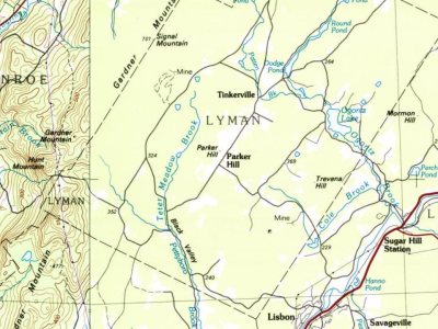
Lyman on the map in 1986

The U.S. Geological Survey’s map of Lyman.

Lyman on the 1986 USGS map1986Mount Washington sheet · 1:100,000

U.S. Geological Survey historical topographic maps (public domain), via Esri’s collection of the scans. The red ring marks the center of Lyman.

Famous people

2 famous people were born in Lyman

Writers, athletes, leaders and more, ranked by how widely they’re known.

See all →
Places that used to be

Lost post offices, old corners, places now gone and burying grounds

Lyman had its own post office from 1808 to 1905.

Lyman
1808–1905
18001910today
Hamlets and corners on the map
Parker HillTinkerville
Gone or out of use
Clough Hill Schoolschool
2cemeteries and burying grounds inside Lyman
Moulton HillPond

US Post Offices dataset (Blevins & Helbock, CC0). Places and cemeteries from the USGS Geographic Names Information System (2021).

Stories next door

History across the town line

Each neighbor’s History grade, on the same three inputs.

Questions about Lyman’s history

What year was Lyman founded?

In 1761, according to Wikidata. Lyman’s post office opened in 1808, and the first U.S. census counted 202 people here in 1790.

Memory lane

What the archives can’t tell you, neighbors can.

Town Square →
Start a conversation
Sources

Where this page comes from

Founding dates: Wikidata, Wikipedia, the U.S. post office records of Blevins & Helbock (CC0) and the Census. Homes by year built: Census ACS 2020–24. National Register of Historic Places: National Park Service (list of May 22, 2026). Old photos, postcards and papers: Wikimedia Commons, the Library of Congress and other public archives, credited on each item’s page. Maps: U.S. Geological Survey historical topographic maps (via Esri) and Sanborn fire-insurance maps (Library of Congress). History text and census tables: Wikipedia (CC BY-SA 4.0). Places that used to be: USGS Geographic Names Information System (2021). How TownRatings grades history →

From Wikimedia Commons (2), Wikipedia, Wikidata and Wikipedia for famous people, U.S. Geological Survey historical maps, U.S. Census counts (via Wikipedia), the US Post Offices dataset (Blevins & Helbock), the USGS Geographic Names Information System and old county and town histories (Internet Archive). Archive images are copied here with their credits and licenses, shown on each photo’s page. Refreshed monthly.