Hinsdale dates to 1753, and 21% of its homes were built before 1940
More historic than 84% of U.S. towns · #56 of 126 in New Hampshire. What drives it
Its Register listings are the Todd Block and the Derby Shop-Goodnow Pail Factory-Holman & Merriman Machine Shop-L. A. Carpenter Machine Shop-Streeter Shop. Below: 12 old photos and papers, maps from 1884 on, and the census since 1790.
Hinsdale dates its founding to 1753 (Wikidata). It appears in the first U.S. census, 1790.
First census: 522 in 17902020 census: 3,948273 years
How did Hinsdale get its name?
Hinsdale was named for Colonel Ebenezer Hinsdale, member of a prominent Deerfield, Massachusetts, family, whose mother had been taken captive in the famed Raid on Deerfield of 1704.
How historic is Hinsdale?
A−
More historic than 84% of U.S. towns, on its age, its old homes and the National Register.
On its age, its old homes and the National Register, Hinsdale is more historic than 84% of U.S. towns, #56 of 126 in New Hampshire. Its age holds the grade up; its National Register listings pull it down.
A−
HistoryA character grade: shown, never part of Hinsdale’s overall grade.
New Hampshire towns list more on the Register than most of the country (a typical New Hampshire town has 9.5 per 10,000 residents, the U.S. 2.4), so Hinsdale’s 5.0 sits near the middle of its state (37% of New Hampshire towns have fewer) while its 2 listings outnumber those of 60% of U.S. towns.
NoteThe founding year comes from Wikidata alone; no second source gives 1753.
How sure. Graded on any two of the three inputs instead, the letter would range from B+ to A. The pre-1940 share is a Census survey estimate (±9.0 points).
Founding year: Wikidata (other dates in Quick answers). Homes: Census ACS 2020–24. National Register: National Park Service, May 2026 list; each listing counted once (boundary changes and added documentation belong to their listing), and a historic district counts its contributing buildings. How TownRatings grades history →
What stands out about Hinsdale’s past
Read from the archive, the National Register and the record. The page puts what stands out first.
Lost a third of its people between 1850 and 1860, then grew 3-fold.
24 censuses, 1790–2020.
U.S. Census Bureau decennial counts, from the census table on Hinsdale’s Wikipedia page.
On the map
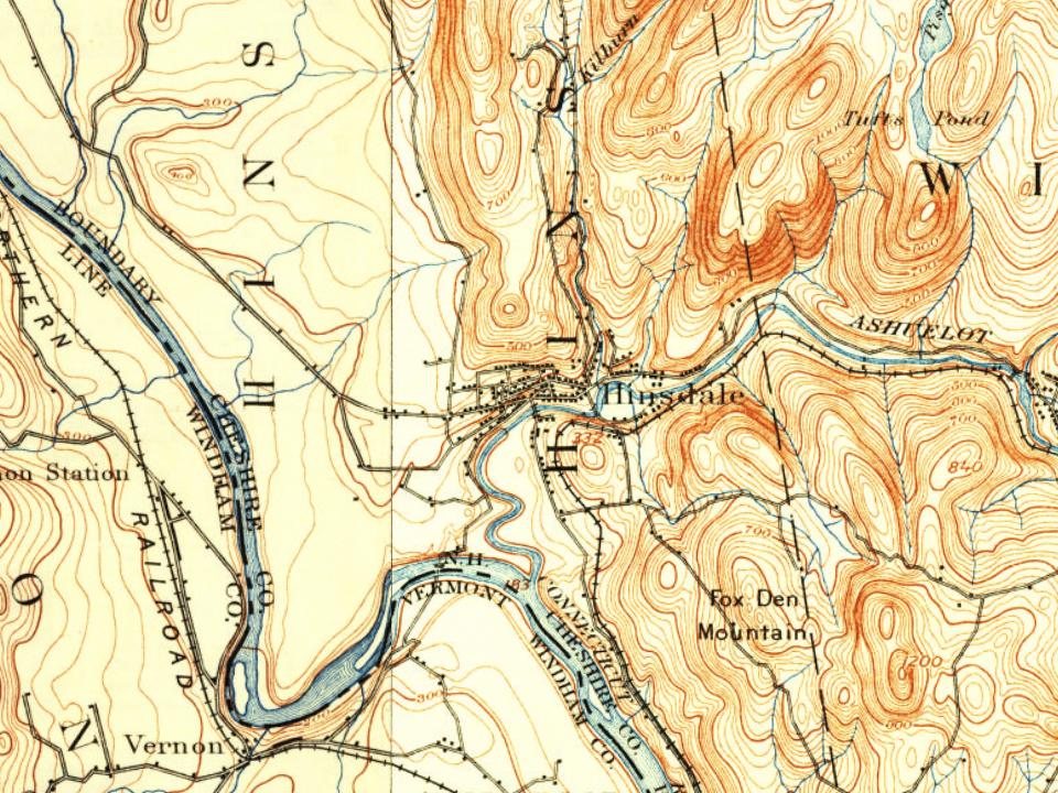
Hinsdale on the map, 1898 to 1998
Every edition of the U.S. Geological Survey’s map of Hinsdale. Tap a year, or press play to watch the town change.
1898Keene sheet · 1:62,500
U.S. Geological Survey historical topographic maps (public domain), via Esri’s collection of the scans. The red ring marks the center of Hinsdale.
Every building
Hinsdale, building by building, 1884–1910
Fire insurance maps drew every building, what it was made of and what it was used for, so insurers could price the risk of fire. Pick a year, then a sheet.
Located in the southwestern corner of the state, Hinsdale was chartered in 1753. It was named for Colonel Ebenezer Hinsdale, member of a prominent Deerfield, Massachusetts, family, whose mother had been taken captive in the famed Raid on Deerfield of 1704. Graduated from Harvard, Hinsdale was ordained to become a missionary for Indians of the Connecticut River Valley. Instead, he would serve as chaplain at Fort Dummer, an important trading post on the Connecticut River, later enlisting as an officer in the army. Then, in 1742, he established Fort Hinsdale, including a trading post and gristmill, reportedly at his own expense. The town's earliest history recounts Indian assaults, raids and captivities.
Passages that mention Hinsdale, cut from the printed page as they were published.
History of the town of Marlborough, Cheshire County, New Hampshire1881 · page 229Read the page →
Read the text
living in sight of the birthplace of Hosea Ballon, and preaching in the meeting-house in which that gifted one had proclaimed the gospel of glad tidings. In 1850, he changed his location to Hinsdale, N.H., taking charge of the Universalist society there, and preaching some part of the time iji West Brattleboro' and Vernon, Vt., in Northfield, Mass., and West Swanzey, N.H. Duriiig his settlement here, he
Text read by machine from the scan; it may contain errors.
Scans and text from the Internet Archive. Books published in 1930 or earlier, which are in the public domain.
Timeline
Hinsdale, 1753 to 2000
Woven from the archive, old maps, post office records, the National Register and the people born here.
Nothing in the archives for these yearsWeddings on Main Street, storms, parades, school pictures, the old store. If it’s in your family album, it belongs here.
In 1753, according to Wikidata. Hinsdale’s post office opened in 1815, and the first U.S. census counted 522 people here in 1790.
How does Hinsdale rank for history?
Hinsdale is more historic than 84% of U.S. towns, #56 of 126 in New Hampshire. The History grade combines the town’s founding era, the share of homes built before 1940 and its National Register listings. It’s a character grade, so it isn’t part of the overall grade. How it works.
What is on the National Register in Hinsdale?
Two places: the Todd Block (listed 1988) and the Derby Shop-Goodnow Pail Factory-Holman & Merriman Machine Shop-L. A. Carpenter Machine Shop-Streeter Shop (2007).
How old are the homes in Hinsdale?
21% of Hinsdale’s homes were built before 1940 (Census estimate, ±9.0 points), against a typical 17% for a New Hampshire town; the median home was built in 1972.
Founding dates: Wikidata, Wikipedia, the U.S. post office records of Blevins & Helbock (CC0) and the Census. Homes by year built: Census ACS 2020–24. National Register of Historic Places: National Park Service (list of May 22, 2026). Old photos, postcards and papers: Wikimedia Commons, the Library of Congress and other public archives, credited on each item’s page. Maps: U.S. Geological Survey historical topographic maps (via Esri) and Sanborn fire-insurance maps (Library of Congress). History text and census tables: Wikipedia (CC BY-SA 4.0). Places that used to be: USGS Geographic Names Information System (2021).
From Wikimedia Commons (16), the Library of Congress (2), the National Register of Historic Places (2), Wikipedia, Wikidata and Wikipedia for famous people, U.S. Geological Survey historical maps, U.S. Census counts (via Wikipedia), the US Post Offices dataset (Blevins & Helbock), the USGS Geographic Names Information System, Sanborn fire insurance maps (Library of Congress) and old county and town histories (Internet Archive). Archive images are copied here with their credits and licenses, shown on each photo’s page. Refreshed monthly.





 1886
 1906
 1906
 1906
 1907
 1907
 1908
 1908
 1908
 1909
 2013
 2013
 2012
 2008
 2008
 2008


