Haverhill dates to 1763, and 26% of its homes were built before 1940
More historic than 98% of U.S. towns · #9 of 126 in New Hampshire. What drives it
4 places in town are on the National Register, among them a historic district with 68 buildings. Below: 5 old photos and papers, maps from 1917 on, and the census since 1790.
Founding year: Wikidata; Wikipedia’s history section gives the same year. First post office: 1794.The full story ↓
History grade
What drives Haverhill’s History grade
On its age, its old homes and the National Register, Haverhill is more historic than 98% of U.S. towns, #9 of 126 in New Hampshire. All 3 inputs are above most U.S. towns; its age ranks highest and its share of homes from before 1940 lowest.
A+
HistoryA character grade: shown, never part of Haverhill’s overall grade.
New Hampshire towns list more on the Register than most of the country (a typical New Hampshire town has 9.5 per 10,000 residents, the U.S. 2.4), so Haverhill’s 152 sits above most of its state (89% of New Hampshire towns have fewer) while its 70 historic buildings outnumber those of 87% of U.S. towns.
How sure. Graded on any two of the three inputs instead, the letter would range from A to A+. The pre-1940 share is a Census survey estimate (±10.8 points). Two sources give 1763.
Founding year: Wikidata (other dates in Quick answers). Homes: Census ACS 2020–24. National Register: National Park Service, May 2026 list; each listing counted once (boundary changes and added documentation belong to their listing), and a historic district counts its contributing buildings. How TownRatings grades history →
What stands out about Haverhill’s past
Read from the archive, the National Register and the record. The page puts what stands out first.
Lost post offices, old corners, places now gone and burying grounds
Haverhill’s post office has been open since 1794. Two other post offices opened and closed inside today’s town.
Haverhill
1794–today
North Haverhill
1826–today
East Haverhill
1844–1954
Woodsville
1853–today
Pike Station
1880–1903
Pike
1903–today
17901910today
Hamlets and corners on the map
Center HaverhillEast HaverhillMountain LakesNorth HaverhillPikeWoodsville
Gone or out of use
Bliss TavernbuildingBrier Hill SchoolschoolHaverhill AcademyschoolOliverian StationlocalePearson HallbuildingSchool Number 6schoolWoodsville Junctionlocale
7cemeteries and burying grounds inside Haverhill
AbbotCenter HaverhillEast HaverhillHorse MeadowLadd StreetNorth HaverhillPine Grove
US Post Offices dataset (Blevins & Helbock, CC0). Places and cemeteries from the USGS Geographic Names Information System (2021).
On the National Register
4 listings protect 70 historic buildings
The country’s official list of buildings and places worth saving.
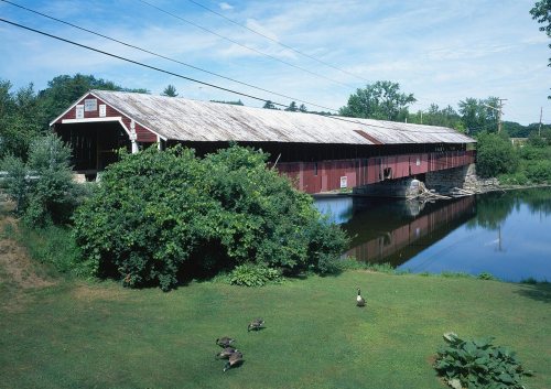
Settled by citizens from Haverhill, Massachusetts, the town was first known as "Lower Cohos". This Lower Cohos name is derived from the original Abenaki people who had a base for agriculture here. It was incorporated in 1763 by colonial Governor Benning Wentworth, and in 1773 became the county seat of Grafton County. Haverhill was the terminus of the old Province Road, which connected the northern and western settlements with the seacoast. By 1859, when the town had 2,405 inhabitants, industries included three gristmills, twelve sawmills, a paper mill, a large tannery, a carriage manufacturer, an iron foundry, seven shoe factories, a printing office, and several mechanic shops. The town is home to the oldest documented covered bridge in the country still standing—the Haverhill–Bath Bridge, built in 1829.
Passages that mention Haverhill, cut from the printed page as they were published.
History of the town of Haverhill, New Hampshire1919 · page 151Read the page →
Read the text
Honb'9 and Rev1 — In the capacity of agent for the Towns of Newbury and Haverhill I promise and Ingage (if Dartmouth College is placed in said Haverhill in New Hamp8) that out of the subscriptions of said Haverhill and Newbury and the town of Bath, that three thousand acres shall be laid out in a convenient farm at the Corner of Haverhill adjoining the southwest corner of the town of Landaff and one thousand acres more laid out in a gore in Bath adjoining said town of Landaff and the three thousand acres in Haverhill as above. And also engage to give five hundred acres more to the HonbIe and Rev1 Trust of said College for the use of said College in a handsome farm Round
Text read by machine from the scan; it may contain errors.
History of the town of Haverhill, New Hampshire1919 · page 383Read the page →
Read the text
The first sawmill was at North Haverhill on Poole Brook, and there was connected with this some sort of a gristmill. This was built by the proprietors of Haverhill and Newbury acting jointly, it having been voted by the Haverhill proprietors at the last meeting held by them in Hampstead March 27, 1764, "to give the proprietors of Newbury one half the privilege of the mills in Haverhill for fourteen years next to come."
Text read by machine from the scan; it may contain errors.
Historical address on the occasion of the one hundred and fiftieth anniversary of the settlement of the town of Haverhill, New Hampshire1912 · page 20Read the page →
Read the text
trouble began. The story of the Piermont controversy is a long and interesting one. Newbury kept its extra mile and more, and Bradford remains a short town. The costly litigation between the Haverhill and Piermont proprietors lasted till 1784, when it was finally settled by the following agreement: "All the meadow lots, all the house lots, and all the first division of 100 acre house lots (these were seven in number) as laid out and bounded by said proprietors of Haverhill, shall be and remain
Text read by machine from the scan; it may contain errors.
Scans and text from the Internet Archive. Books published in 1930 or earlier, which are in the public domain.
By decade
Haverhill, decade by decade
3 decades in the archive, from the 1910s to the 1930s. Scroll each row; tap a photo for its story.
Nothing in the archives for these yearsWeddings on Main Street, storms, parades, school pictures, the old store. If it’s in your family album, it belongs here.
In 1763, according to Wikidata and Wikipedia’s history of the town. Haverhill’s post office opened in 1794, and the first U.S. census counted 552 people here in 1790.
How does Haverhill rank for history?
Haverhill is more historic than 98% of U.S. towns, #9 of 126 in New Hampshire. The History grade combines the town’s founding era, the share of homes built before 1940 and its National Register listings. It’s a character grade, so it isn’t part of the overall grade. How it works.
What is on the National Register in Haverhill?
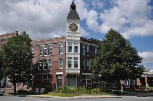
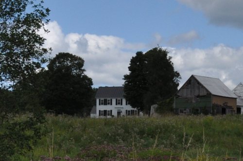
4 listings: 2 buildings, 1 historic district, the Haverhill Corner Historic District, with 68 contributing buildings, and 2 structures. 70 historic buildings in all.
How old are the homes in Haverhill?
26% of Haverhill’s homes were built before 1940 (Census estimate, ±10.8 points), against a typical 17% for a New Hampshire town; the median home was built in 1975.
Founding dates: Wikidata, Wikipedia, the U.S. post office records of Blevins & Helbock (CC0) and the Census. Homes by year built: Census ACS 2020–24. National Register of Historic Places: National Park Service (list of May 22, 2026). Old photos, postcards and papers: Wikimedia Commons, the Library of Congress and other public archives, credited on each item’s page. Maps: U.S. Geological Survey historical topographic maps (via Esri) and Sanborn fire-insurance maps (Library of Congress). History text and census tables: Wikipedia (CC BY-SA 4.0). Places that used to be: USGS Geographic Names Information System (2021).
From Wikimedia Commons (23), the Library of Congress (1), the National Register of Historic Places (5), Wikipedia, Wikidata and Wikipedia for famous people, U.S. Geological Survey historical maps, U.S. Census counts (via Wikipedia), the US Post Offices dataset (Blevins & Helbock), the USGS Geographic Names Information System, Sanborn fire insurance maps (Library of Congress) and old county and town histories (Internet Archive). Archive images are copied here with their credits and licenses, shown on each photo’s page. Refreshed monthly.







 1913
 1917
 2025
 2025
 2025
 2022
 2016
 2014
 2014
 2014
 2014
 2014
 2013
 2013
 2011
 2011
 2011
 2011
 2011
 2011
 2011


