Deerfield dates to 1766, and 19% of its homes were built before 1940
More historic than 93% of U.S. towns · #29 of 126 in New Hampshire. What drives it
3 places in town are on the National Register, among them two historic districts with 27 buildings between them. Below: 3 old photos and papers, maps from 1917 on, and the census since 1790.
Founding year: Wikidata. First post office: 1807.The full story ↓
History grade
What drives Deerfield’s History grade
On its age, its old homes and the National Register, Deerfield is more historic than 93% of U.S. towns, #29 of 126 in New Hampshire. All 3 inputs are above most U.S. towns; its age ranks highest and its share of homes from before 1940 lowest.
A
HistoryA character grade: shown, never part of Deerfield’s overall grade.
New Hampshire towns list more on the Register than most of the country (a typical New Hampshire town has 9.5 per 10,000 residents, the U.S. 2.4), so Deerfield’s 56.8 sits above most of its state (77% of New Hampshire towns have fewer) while its 28 historic buildings outnumber those of 81% of U.S. towns.
NoteThe founding year comes from Wikidata alone; no second source gives 1766.
How sure. Graded on any two of the three inputs instead, the letter would range from A− to A+. The pre-1940 share is a Census survey estimate (±6.0 points).
Founding year: Wikidata (other dates in Quick answers). Homes: Census ACS 2020–24. National Register: National Park Service, May 2026 list; each listing counted once (boundary changes and added documentation belong to their listing), and a historic district counts its contributing buildings. How TownRatings grades history →
What stands out about Deerfield’s past
Read from the archive, the National Register and the record. The page puts what stands out first.
Deerfield was originally part of Nottingham. In 1756, residents petitioned for organization of a separate parish, but were denied. In 1765, while a second petition was pending, two local hunters presented colonial governor Benning Wentworth with a deer. Permission was granted, and "Deerfield" was incorporated in 1766. The incorporation act for Deerfield was signed by three members of the Leavitt family, including Capt. Samuel Leavitt who later was one of the town's first selectmen. Leavitts Hill in Deerfield was named for the family, who had first settled in nearby Exeter.
Passages that mention Deerfield, cut from the printed page as they were published.
History of Rockingham County, New Hampshire1915 · page 276Read the page →
Read the text
In 1765 the inhabitants again petitioned for separation from the parent town and the prayer was granted, and the new parish took the name of Deerfield. Incorporation. — The act cyf' incorporation bears the date January 8, 1766, and is signed bj' Gov. Benning W'entwo'rth. The petition was signed by the following persons : "Samll Leavitt, Obadiah Marston, Thos Simpson. Eliphelet Griffeen, Abraham True, Isaac Shepard. Samuel Tilton, Peter Batchelder, Robert Cram, Patten Simpson, Nathaniel Batchelder. Jr., Thomas Brown, John Batchelder. Moses Thomson, Samll Ho\-t. Peter Leavitt,
Text read by machine from the scan; it may contain errors.
History of the town of Candia, Rockingham County, N.H.1893Read the page →
Read the text
About the year 1866, some of the citizens who lived in the southwest part of the town, and in the northwest part of Auburn endeavored to have a new road to Manchester laid out from Deerfield South Road to Manchester across the Turnpike near the School house in School District No. 13. After several trials and much opposition, the scheme was abandoned.
Text read by machine from the scan; it may contain errors.
History of Rockingham County, New Hampshire1915 · page 622Read the page →
Read the text
There were old Indian graves in the same vicinity. The next garrison house was built by Capt. Jonathan Longfellow, on the farm now owned by the Misses Marston. not far from Deerfield Parade. The Longfellow garrison was in possession of the Marston family from 1765 till it was torn down a half century ago. When it was built, about 1740, there was no other house between it and Canada: it was on the border line of Indian attack.
Text read by machine from the scan; it may contain errors.
History of the town of Candia, Rockingham County, N.H.1893 · page 41Read the page →
Read the text
Brown, son of the late Aaron Brown. About a mile farther on it operates a saw mill owned by Samuel A. Davis. It then crosses the road leading from High Street to Deerfield South Road and from thence it runs to a saw mill situated on lot No. 42, 3d division. It then crosses North road and flows about a mile and a half to lot No. 38, 3d division, near the New Boston road where there was once a saw mill and srrist mill. The stream then crosses the road which leads from
Text read by machine from the scan; it may contain errors.
Scans and text from the Internet Archive. Books published in 1930 or earlier, which are in the public domain.
Timeline
Deerfield, 1766 to 2020
Woven from the archive, old maps, post office records, the National Register and the people born here.
Nothing in the archives for these yearsWeddings on Main Street, storms, parades, school pictures, the old store. If it’s in your family album, it belongs here.
In 1766, according to Wikidata. Deerfield’s post office opened in 1807, and the first U.S. census counted 1,619 people here in 1790.
How does Deerfield rank for history?
Deerfield is more historic than 93% of U.S. towns, #29 of 126 in New Hampshire. The History grade combines the town’s founding era, the share of homes built before 1940 and its National Register listings. It’s a character grade, so it isn’t part of the overall grade. How it works.
What is on the National Register in Deerfield?
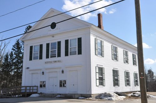
Three places: the Town House (listed 1980), the Deerfield Center Historic District (2002) and the Old Deerfield Center Historic District (2020).
How old are the homes in Deerfield?
19% of Deerfield’s homes were built before 1940 (Census estimate, ±6.0 points), against a typical 17% for a New Hampshire town; the median home was built in 1985.
Founding dates: Wikidata, Wikipedia, the U.S. post office records of Blevins & Helbock (CC0) and the Census. Homes by year built: Census ACS 2020–24. National Register of Historic Places: National Park Service (list of May 22, 2026). Old photos, postcards and papers: Wikimedia Commons, the Library of Congress and other public archives, credited on each item’s page. Maps: U.S. Geological Survey historical topographic maps (via Esri) and Sanborn fire-insurance maps (Library of Congress). History text and census tables: Wikipedia (CC BY-SA 4.0). Places that used to be: USGS Geographic Names Information System (2021).
From Wikimedia Commons (8), the Library of Congress (2), Wikidata (2), the National Register of Historic Places (3), Wikipedia, Wikidata and Wikipedia for famous people, U.S. Geological Survey historical maps, U.S. Census counts (via Wikipedia), the US Post Offices dataset (Blevins & Helbock), the USGS Geographic Names Information System and old county and town histories (Internet Archive). Archive images are copied here with their credits and licenses, shown on each photo’s page. Refreshed monthly.




 Date?
 2018
 2018
 2018
 2018
 2018
 2018
 2007


