Culbertson was created in June 1887 following the arrival of the Great Northern Railway, then known as the St. Paul, Minneapolis & Manitoba Railway. The town was named after Major Alexander Culbertson, former head of the American Fur Company's Fort Union, 23 miles (37 km) to the east.
The settlement of Culbertson followed hard on the heels of the 1886-87 watershed years for the early cattle industry. As a result, the first settlers in the area raised horses for the US Cavalry’s various Montana and Dakota posts. As cattle prices slowly rebounded, the range was once again stocked with cattle, though the second wave of cattlemen utilized hardy English breeds instead of the Texas longhorns of the earlier outfits.
Nothing in the archives for these yearsWeddings on Main Street, storms, parades, school pictures, the old store. If it’s in your family album, it belongs here.
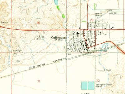
Every edition of the U.S. Geological Survey’s map of Culbertson. Tap a year, or press play to watch the town change.
1969Culbertson sheet · 1:24,000
U.S. Geological Survey historical topographic maps (public domain), via Esri’s collection of the scans. The red ring marks the center of Culbertson.
Every building
Culbertson, building by building, 1910–1930
Fire insurance maps drew every building, what it was made of and what it was used for, so insurers could price the risk of fire. Pick a year, then a sheet.
Founding dates: Wikidata, Wikipedia, the U.S. post office records of Blevins & Helbock (CC0) and the Census. Homes by year built: Census ACS 2020–24. National Register of Historic Places: National Park Service (list of May 22, 2026). Old photos, postcards and papers: Wikimedia Commons, the Library of Congress and other public archives, credited on each item’s page. Maps: U.S. Geological Survey historical topographic maps (via Esri) and Sanborn fire-insurance maps (Library of Congress). History text and census tables: Wikipedia (CC BY-SA 4.0). Places that used to be: USGS Geographic Names Information System (2021). How TownRatings grades history →
From Wikimedia Commons (2), the Library of Congress (3), Wikipedia, Wikidata and Wikipedia for famous people, U.S. Geological Survey historical maps, U.S. Census counts (via Wikipedia), the US Post Offices dataset (Blevins & Helbock), the USGS Geographic Names Information System and Sanborn fire insurance maps (Library of Congress). Archive images are copied here with their credits and licenses, shown on each photo’s page. Refreshed monthly.


 1916
 1916
 2017
 2013


