On its age, its old homes and the National Register, Bonner-West Riverside is more historic than 57% of U.S. towns. Its share of homes from before 1940 holds the grade up; its National Register listings pull it down.
B
HistoryA character grade: shown, never part of Bonner-West Riverside’s overall grade.
Montana towns list more on the Register than most of the country (a typical Montana town has 12.7 per 10,000 residents, the U.S. 2.4), so Bonner-West Riverside’s 0.0 sits below most of its state (16% of Montana towns have fewer) while its 0 listings outnumber those of 23% of U.S. towns.
How sure. Graded on two of the three inputs, so a change in either one moves the letter more than it would with three. The pre-1940 share is a Census survey estimate (±12.3 points).
Founding year: our sources. Homes: Census ACS 2020–24. National Register: National Park Service, May 2026 list; each listing counted once (boundary changes and added documentation belong to their listing), and a historic district counts its contributing buildings. How TownRatings grades history →
What stands out about Bonner-West Riverside’s past
Read from the archive, the National Register and the record. The page puts what stands out first.
Old hamlets and crossroads still carry their names on the map.
Bonner
1888–today
Milltown
1912–today
18801950today
Hamlets and corners on the map
Big Pines Mobile CourtBonnerCarols CourtCircle 'J' Mobile ParkGreenland Park Trailer CourtHarveys Mobile Home CourtMilltownMountain View CourtPinegrovePinegrove Trailer ParkWest Riverside
Gone or out of use
Cantonment WrightlocaleMilltownlocaleSwedish Community ChurchchurchTurbinelocale
US Post Offices dataset (Blevins & Helbock, CC0). Places and cemeteries from the USGS Geographic Names Information System (2021).
On the map
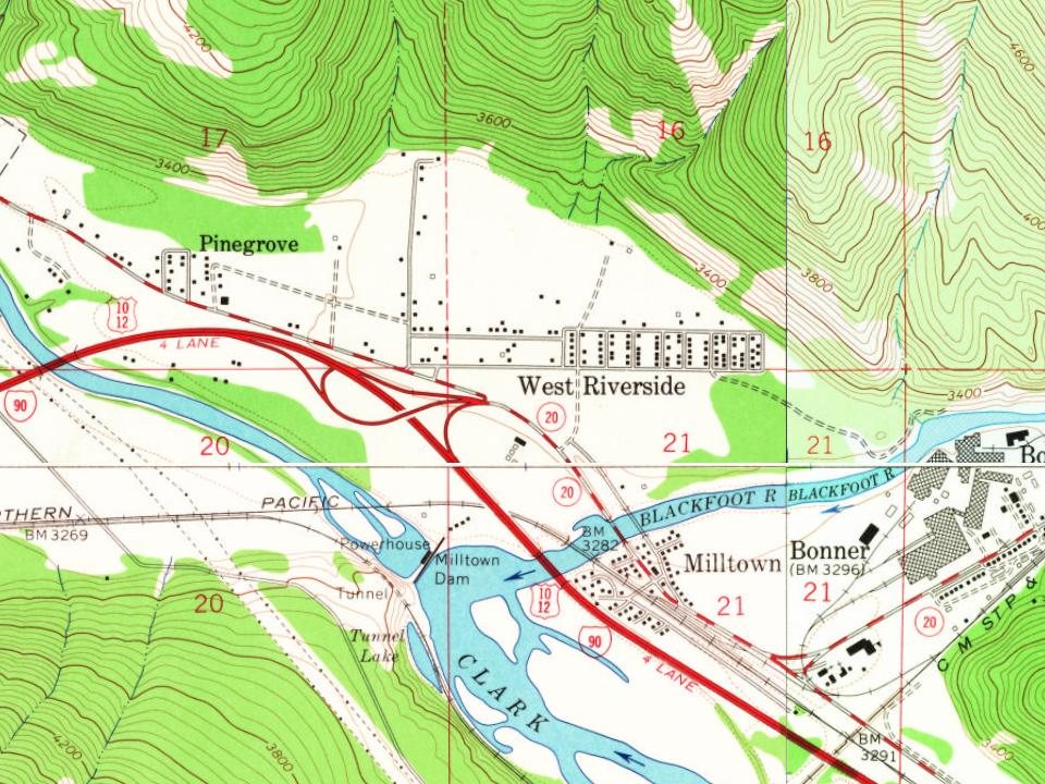
Bonner-West Riverside on the map, 1903 to 1999
Every edition of the U.S. Geological Survey’s map of Bonner-West Riverside. Tap a year, or press play to watch the town change.
1903Bonner sheet · 1:125,000
U.S. Geological Survey historical topographic maps (public domain), via Esri’s collection of the scans. The red ring marks the center of Bonner-West Riverside.
The story
How Bonner-West Riverside came to be
From Wikipedia’s history of Bonner-West Riverside.
The area east of Missoula was born with the sawmill located there by Andrew B. Hammond. Hammond, with partners Richard Eddy and Edward Bonner, founders of the Montana Improvement Company (MIC), enticed the nearly complete Northern Pacific Railroad (NP) to pass through Missoula. They were rewarded with lucrative NP lumber contracts. Hammond, on behalf of the MIC, purchased land east of Missoula on Blackfoot River for a sawmill and dam to hold the mill's supply of logs. The Blackfoot Milling Company began operation on 6 June 1886 and by August produced an average of 55,000 board feet of lumber per day. In addition to the NP contracts, the Blackfoot Mill (or Hammond Mill) provided stulls (mining shaft supports) and lumber for construction. It continued to expand and in 1889 it produced 24 million board feet of lumber and was considered the largest mill between Wisconsin and the West Coast.…
Bonner-West Riverside is more historic than 57% of U.S. towns. The History grade combines the town’s founding era, the share of homes built before 1940 and its National Register listings. It’s a character grade, so it isn’t part of the overall grade. How it works.
How old are the homes in Bonner-West Riverside?
33% of Bonner-West Riverside’s homes were built before 1940 (Census estimate, ±12.3 points), against a typical 13% for a Montana town; the median home was built in 1979.
Founding dates: Wikidata, Wikipedia, the U.S. post office records of Blevins & Helbock (CC0) and the Census. Homes by year built: Census ACS 2020–24. National Register of Historic Places: National Park Service (list of May 22, 2026). Old photos, postcards and papers: Wikimedia Commons, the Library of Congress and other public archives, credited on each item’s page. Maps: U.S. Geological Survey historical topographic maps (via Esri) and Sanborn fire-insurance maps (Library of Congress). History text and census tables: Wikipedia (CC BY-SA 4.0). Places that used to be: USGS Geographic Names Information System (2021).
From Wikipedia, U.S. Geological Survey historical maps, U.S. Census counts (via Wikipedia), the US Post Offices dataset (Blevins & Helbock) and the USGS Geographic Names Information System. Archive images are copied here with their credits and licenses, shown on each photo’s page. Refreshed monthly.