Sullivan’s post office opened in 1860, and 2 of its places are on the National Register
More historic than 42% of U.S. towns · #133 of 247 in Missouri. What drives it
Most of Sullivan was built recently: 5% of its homes predate 1940 and the median home dates from 1976. Its Register listings are the Harney, Maj. Gen. William S., Summer Home and the Shamrock Court. Below: maps from 1914 on and the census since 1880.
The Sullivan post office opened in 1860, the earliest record of the town by name. Another post office, Mount Helicon (1856), opened inside today’s city and later closed.
First census: 155 in 18802020 census: 6,906166 years
How historic is Sullivan?
C+
More historic than 42% of U.S. towns, on its age, its old homes and the National Register.
Founding year: the first Sullivan post office (Blevins & Helbock, CC0).The full story ↓
History grade
What drives Sullivan’s History grade
On its age, its old homes and the National Register, Sullivan is more historic than 42% of U.S. towns, #133 of 247 in Missouri. Its National Register listings hold the grade up; its share of homes from before 1940 pulls it down.
C+
HistoryA character grade: shown, never part of Sullivan’s overall grade.
Missouri towns list about as much on the Register as the country (a typical Missouri town has 2.4 per 10,000 residents, the U.S. 2.4), so Sullivan’s 6.3 sits above most of its state (68% of Missouri towns have fewer) while its 4 historic buildings outnumber those of 68% of U.S. towns.
How sure. Graded on any two of the three inputs instead, the letter would range from C− to B−. The pre-1940 share (±2.3 points) is firm at this size. The founding year is the first post office, not a stated founding date.
Founding year: the first post office (other dates in Quick answers). Homes: Census ACS 2020–24. National Register: National Park Service, May 2026 list; each listing counted once (boundary changes and added documentation belong to their listing), and a historic district counts its contributing buildings. How TownRatings grades history →
What stands out about Sullivan’s past
Read from the archive, the National Register and the record. The page puts what stands out first.
On January 28, 1839, 120 acres were conveyed by the U.S. Government to Garretson (also spelled Garrison) P. Hardy. Purchased according to provisions of the Act of Congress for the sale of public lands (dated April 1820). Then in June 1848, Garretson sold the acreage to William & Mary Smith for $150. In June 1856, Stephen & Dorcas Sullivan purchased the acreage, plus an additional 49 acres from Smith for the sum of $400. This was the future site of the original town. On July 25, 1856, when a post office was established in present-day Sullivan, the local postmaster named the place "Mount Helicon". This short-lived name was after an actual mountain in Greece that was the mythical sanctuary of the Muses. In 1859, Stephen Sullivan donated ground for railroad right-of-way and built the depot himself. The railroad named the station “Sullivan” prompting the post office to change to Sullivan.
Passages that mention Sullivan, cut from the printed page as they were published.
History of Adair, Sullivan, Putnam and Schuyler counties, Missouri, from the earliest times to the present1888 · page 145Read the page →
Read the text
County, Ky., in 1814, and, having married Mrs. Susan McDaniels in about 1832, settled in Linn County, one mile west of Browning, and one-fourth of a mile south of the southern boundary of Sullivan County, in 1837, taking up forty acres of land on West Locust Creek, in Sullivan County, about one-half mile north of Linn County, at about the same time or a little later. He preached in most or all of the early settlements in Sullivan County, including Milan, in which town he preached in the schoolhouse, before
Text read by machine from the scan; it may contain errors.
History of Adair, Sullivan, Putnam and Schuyler Counties, Missouri1888 · page 143Read the page →
Read the text
County, Ky., in 1814, and, having married Mrs. Susan McDaniels in about 1832, settled in Linn County, one mile west of Browning, and one-fourth of a mile south of the southern boundary of Sullivan County, in 1837, taking up forty acres of land on West Locust Creek, in Sullivan County, about one-half mile north of Linn County, at about the same time or alittle later. He preached in most or all of the early settlements in Sullivan County, including Milan, in which town he preached in the schoolhouse, before
Text read by machine from the scan; it may contain errors.
History of Adair, Sullivan, Putnam and Schuyler counties, Missouri, from the earliest times to the present1888 · page 51Read the page →
Read the text
Settlement with Linn County. — Section 2 provided that " the county court of Linn County is hereby authorized and required to pay over to Sullivan County all the revenue which has been or may be collected by said county of Linn, within the territory of Sullivan County, since the 17th of February, 1843, after deducting all expenses of assessing and collecting the same, and all the expenses arising from criminal prosecution originating within said territory of Sullivan, and all moneys which may have been
Text read by machine from the scan; it may contain errors.
History of Adair, Sullivan, Putnam and Schuyler Counties, Missouri1888 · page 160Read the page →
Read the text
Section 1. Therefore, be it ordained by the Board of Trustees of the town of Milan, in Sullivan County, in the State of Missouri, that an election of the legal voters of said town of Milan be held at the Court-house, in said town of Milan, on the 4th day of September, 1877, for the purpose of taking the sense of ‘the legal voters of said town, as to whether they will reorganize said town of Milan, under and by virtue of the act of the General Assembly of the State of Missouri, passed at its last session, entitled ‘‘An Act for the Classification of Cities and Towns,” which proposition is hereby submitted to be voted on at
Text read by machine from the scan; it may contain errors.
Scans and text from the Internet Archive. Books published in 1930 or earlier, which are in the public domain.
Timeline
Sullivan, 1820 to 1970
Woven from the archive, old maps, post office records, the National Register and the people born here.
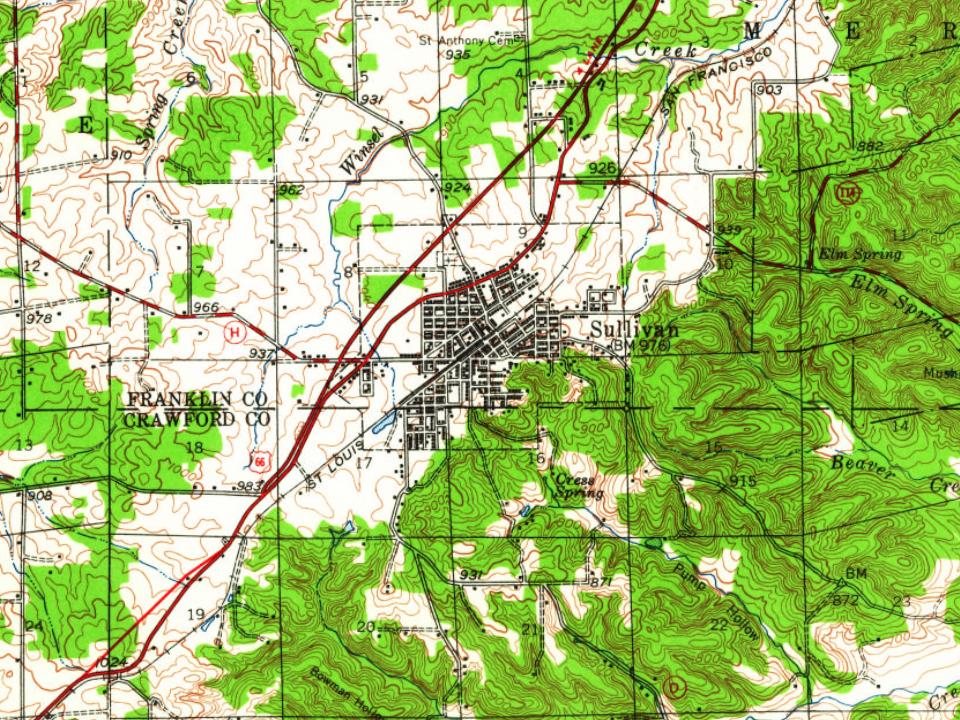
Every edition of the U.S. Geological Survey’s map of Sullivan. Tap a year, or press play to watch the town change.
1947Sullivan sheet · 1:62,500
U.S. Geological Survey historical topographic maps (public domain), via Esri’s collection of the scans. The red ring marks the center of Sullivan.
Every building
Sullivan, building by building, 1914–1924
Fire insurance maps drew every building, what it was made of and what it was used for, so insurers could price the risk of fire. Pick a year, then a sheet.
1914Sheet 1 of 1
Edition
Sheets
BrickWoodStone
Sanborn Map Company, via the Library of Congress. Editions published in 1930 or earlier, which are in the public domain.
On the National Register
2 historic places in Sullivan
The country’s official list of buildings and places worth saving.
The Sullivan post office opened in 1860, the earliest record of the town by name (U.S. post office records).
How does Sullivan rank for history?
Sullivan is more historic than 42% of U.S. towns, #133 of 247 in Missouri. The History grade combines the town’s founding era, the share of homes built before 1940 and its National Register listings. It’s a character grade, so it isn’t part of the overall grade. How it works.
What is on the National Register in Sullivan?
Two places: the Harney, Maj. Gen. William S., Summer Home (listed 1984) and the Shamrock Court (2022).
How old are the homes in Sullivan?
5% of Sullivan’s homes were built before 1940 (Census estimate, ±2.3 points), against a typical 8.4% for a Missouri town; the median home was built in 1976.
Founding dates: Wikidata, Wikipedia, the U.S. post office records of Blevins & Helbock (CC0) and the Census. Homes by year built: Census ACS 2020–24. National Register of Historic Places: National Park Service (list of May 22, 2026). Old photos, postcards and papers: Wikimedia Commons, the Library of Congress and other public archives, credited on each item’s page. Maps: U.S. Geological Survey historical topographic maps (via Esri) and Sanborn fire-insurance maps (Library of Congress). History text and census tables: Wikipedia (CC BY-SA 4.0). Places that used to be: USGS Geographic Names Information System (2021).
From Wikimedia Commons (3), the National Register of Historic Places (2), Wikipedia, Wikidata and Wikipedia for famous people, U.S. Geological Survey historical maps, U.S. Census counts (via Wikipedia), the US Post Offices dataset (Blevins & Helbock), the USGS Geographic Names Information System, Sanborn fire insurance maps (Library of Congress) and old county and town histories (Internet Archive). Archive images are copied here with their credits and licenses, shown on each photo’s page. Refreshed monthly.



 2026
 2026
 2019