Guest, Sign inJoin

Post to Hughesville

We’ll email a one-tap link to publish your post. No password, and nothing is public until you click it.
Already a member? Sign in
–Not graded
History · Hughesville

Hughesville dates to 1871, and 35% of its homes were built before 1940

Below: 2 old photos and papers, maps from 1939 on, and the census since 1960.

1871founded
0on the National Register
35%homes built before 1940
2old photos & papers
1famous people
From Hughesville’s archive · credits on each photo
Quick answers

How Hughesville began

When was Hughesville founded?

1871

Hughesville dates its founding to 1871 (Wikipedia’s history). The census first counted it in 1960.

First census: 134 in 19602020 census: 150155 years
Founding year: Wikipedia. First post office: 1872.The full story ↓

What stands out about Hughesville’s past

Read from the archive, the National Register and the record. The page puts what stands out first.

★ What stands out · Help out

Start Hughesville’s collection

The first neighbors to add old photos shape how Hughesville’s history is told.

Decades since 1900 with photos
00s10s20s30s40s50s60s70s80s90s
1 of 10 decades. The empty ones are waiting for someone’s album.
The story

How Hughesville came to be

From Wikipedia’s history of Hughesville.

Read it all →

Hughesville was platted in 1871 by Reece Hughes, who gave the town his last name. A post office called Hughesville has been in operation since 1872.

The Osage Farms Resettlement Properties in Pettis County, Missouri includes properties listed on the National Register of Historic Places in 1991. The Gen. David Thomson House was listed in 1982.

Text from Wikipedia, licensed CC BY-SA 4.0.

From the old history books

What they wrote about Hughesville, 1882–1919

Passages that mention Hughesville, cut from the printed page as they were published.

borders. The town of Hughesville was named in honor of one of its influential citizens — Reece Hughes — who laid out the town while this township was yet a part of Houstonia township. It is with difficulty that we obtain the names of the early settlers of this township, because of its alliance with…
History of Pettis County, Missouri1919 · page 178Read the page →
Read the text

borders. The town of Hughesville was named in honor of one of its influential citizens — Reece Hughes — who laid out the town while this township was yet a part of Houstonia township. It is with difficulty that we obtain the names of the early settlers of this township, because of its alliance with Houstonia and Longwood township, prior to August 14, 1878, when it was created a separate township by order of the Pettis County Court, and while the names of many of them might, in a measure, constitute a repetition, we will endeavor to give some of them: George

Text read by machine from the scan; it may contain errors.
is one of the latest in organization. It was originally part of Bowling Green, and then part of Heath’s Creek and Mt. Sterling. It was organ¬ ized again in 1873 and in 1878 it gave up sixteen sections out of its south and western borders to help organize the township of Hughesville. It is bounded o…
History of Pettis County, Missouri1919 · page 188Read the page →
Read the text

is one of the latest in organization. It was originally part of Bowling Green, and then part of Heath’s Creek and Mt. Sterling. It was organ¬ ized again in 1873 and in 1878 it gave up sixteen sections out of its south and western borders to help organize the township of Hughesville. It is bounded on the north by Saline county, on the west by Houstonia and Hughesville townships, on the east by Heath’s Creek township and on the

Text read by machine from the scan; it may contain errors.
Mr. Elijah Magoflin was a wealthy farmer who resided about one mile west of the present town of Hughesville. He was a famous hunter, a dead shot, but withal a very quiet man and possessed of the most determined courage. He was known as a pronounced southern man.
The History of Pettis County, Missouri, including an authentic history of Sedalia, other towns and townships, together with ... biographical sketches ..1882 · page 411Read the page →
Read the text

Mr. Elijah Magoflin was a wealthy farmer who resided about one mile west of the present town of Hughesville. He was a famous hunter, a dead shot, but withal a very quiet man and possessed of the most determined courage. He was known as a pronounced southern man.

Text read by machine from the scan; it may contain errors.
shop at Hughesville. Since his comingj to Hughesville, Mr. M. has built up an extensive and satisfactory business in his Hne. He has established a reputation for honest and reliable work, which insures for him a large and satisfactory trade. He is a man who is master of his trade and can accomplish…
The History of Pettis County, Missouri, including an authentic history of Sedalia, other towns and townships, together with ... biographical sketches ..1882 · page 783Read the page →
Read the text

shop at Hughesville. Since his comingj to Hughesville, Mr. M. has built up an extensive and satisfactory business in his Hne. He has established a reputation for honest and reliable work, which insures for him a large and satisfactory trade. He is a man who is master of his trade and can accomplish anything in his line; his work will compare favorably with any done in our large cities in point of reliability, and beauty of finish. He is enjoying the comforts of a beautiful homestead, which consists of fifteen acres adjoining the town. Has an interesting and intelligent family. His

Text read by machine from the scan; it may contain errors.

Scans and text from the Internet Archive. Books published in 1930 or earlier, which are in the public domain.

Timeline

Hughesville, 1871 to 1988

Woven from the archive, old maps, post office records, the National Register and the people born here.

  1. 19th century
  2. 1871
    FoundingHughesville is established
  3. 1872Post officeThe Hughesville post office opens
  4. 20th century
  5. 1939In the archiveOsage Farms project headquarters are located over the general store
  6. 1939On the mapFirst mapped by the U.S. Geological Survey
  7. 1988Born hereTim Barnes is born here
By decade

Hughesville, decade by decade

One decade in the archive so far: the 1930s. Scroll each row; tap a photo for its story.

1940s–1990snothing yet
Nothing in the archives for these yearsWeddings on Main Street, storms, parades, school pictures, the old store. If it’s in your family album, it belongs here.
Add from your album
On the map

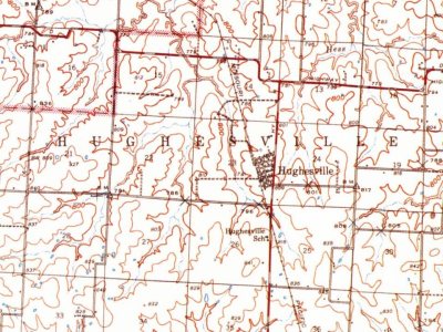
Hughesville on the map, 1939 to 1973

Every edition of the U.S. Geological Survey’s map of Hughesville. Tap a year, or press play to watch the town change.

Hughesville on the 1939 USGS mapHughesville on the 1941 USGS mapHughesville on the 1973 USGS map1939Sweet Springs sheet · 1:62,500

U.S. Geological Survey historical topographic maps (public domain), via Esri’s collection of the scans. The red ring marks the center of Hughesville.

Then & now

Stand where they stood

No then-and-now pairs yet. Take a photo from the same spot as an old one and they appear here side by side.

Osage Farms project headquarters are located over the general store
Retake this viewOsage Farms project headquarters are located over the general store, 1939

Find the spot, match the angle, and add your photo. It becomes the first then-and-now pair on Hughesville’s page.

Retake this view · +15
People over time

Hughesville, census by census

01002001960198020002020Peak: 183

Between 92 and 183 people in every census since 1960.

7 censuses, 1960–2020.

U.S. Census Bureau decennial counts, from the census table on Hughesville’s Wikipedia page.

Questions about Hughesville’s history

What year was Hughesville founded?

In 1871, according to Wikipedia’s history of the town. Hughesville’s post office opened in 1872, and the census of 1960 counted 134 people here.

Memory lane

What the archives can’t tell you, neighbors can.

Town Square →
Start a conversation
Sources

Where this page comes from

Founding dates: Wikidata, Wikipedia, the U.S. post office records of Blevins & Helbock (CC0) and the Census. Homes by year built: Census ACS 2020–24. National Register of Historic Places: National Park Service (list of May 22, 2026). Old photos, postcards and papers: Wikimedia Commons, the Library of Congress and other public archives, credited on each item’s page. Maps: U.S. Geological Survey historical topographic maps (via Esri) and Sanborn fire-insurance maps (Library of Congress). History text and census tables: Wikipedia (CC BY-SA 4.0). Places that used to be: USGS Geographic Names Information System (2021). How TownRatings grades history →

From Wikimedia Commons (1), the Library of Congress (2), Wikipedia, Wikidata and Wikipedia for famous people, U.S. Geological Survey historical maps, U.S. Census counts (via Wikipedia), the US Post Offices dataset (Blevins & Helbock), the USGS Geographic Names Information System and old county and town histories (Internet Archive). Archive images are copied here with their credits and licenses, shown on each photo’s page. Refreshed monthly.