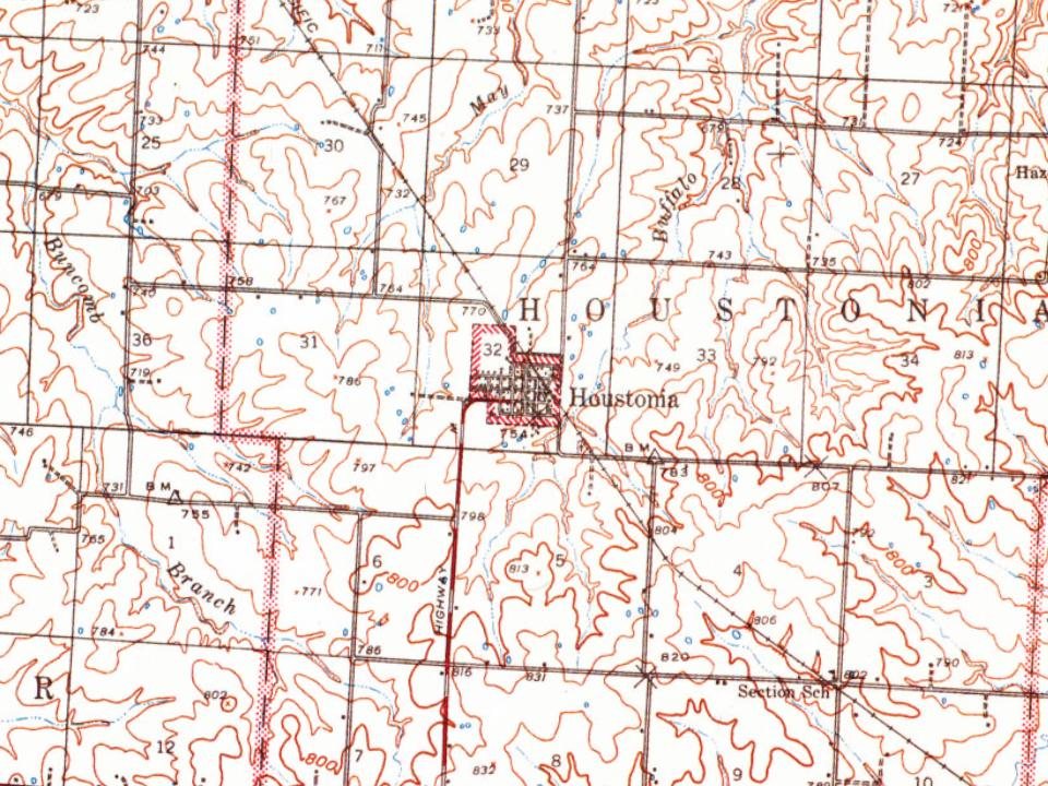
Houstonia was platted in 1871. The community was named for Gen. Thomas F. Houston, an early settler. A post office called Houstonia has been in operation since 1872.
The Osage Farms Resettlement Properties in Pettis County, Missouri includes properties listed on the National Register of Historic Places in 1991.
Passages that mention Houstonia, cut from the printed page as they were published.
History of Pettis County, Missouri1919 · page 304Read the page →
Read the text
Houstonia. — In the center of a broad expanse of beautiful table land, extending back as far as the eye can reach in any direction, is situated the town of Houstonia. It was named in honor of Col. Thomas F. Houston. It is not the purpose of the writer to attempt to give a detailed or exhaustive description of this locality, as it must be seen to be appreciated. Suffice it to say, that here is a section of country that is seldom equalled, and never surpassed, in point of beauty or produc¬ tiveness, by any county in the State. It is the most important shipping
Text read by machine from the scan; it may contain errors.
History of Pettis County, Missouri1919 · page 178Read the page →
Read the text
borders. The town of Hughesville was named in honor of one of its influential citizens — Reece Hughes — who laid out the town while this township was yet a part of Houstonia township. It is with difficulty that we obtain the names of the early settlers of this township, because of its alliance with Houstonia and Longwood township, prior to August 14, 1878, when it was created a separate township by order of the Pettis County Court, and while the names of many of them might, in a measure, constitute a repetition, we will endeavor to give some of them: George
Text read by machine from the scan; it may contain errors.
The History of Pettis County, Missouri, including an authentic history of Sedalia, other towns and townships, together with ... biographical sketches ..1882 · page 769Read the page →
Read the text
In the center of a broad expanse of beautiful table land, extending back as far as the eye can reach in any direction, is situated the enterprising town of Houstonia. It was named in honor of Col. Thos. F. Houston, whose residence is near its corporation. To give a vivid description of the surrounding country, with its many elegant and commodious farm residences, which dot the prairie in a promiscuous display, and the beautiful streams, along whose banks are here and there skirts of timber, and the many herds of fine stock roaming over broad fields and rich pastures,
Text read by machine from the scan; it may contain errors.
The History of Pettis County, Missouri, including an authentic history of Sedalia, other towns and townships, together with ... biographical sketches ..1882 · page 757Read the page →
Read the text
In the northern part of Pettis County is situated the beautiful scope of country comprising Houstonia Township, and running diagonally across the township is the branch line of the Missouri Pacific Railway, connecting this township with the enterprising city of Sedalia, giving it every connection for transportation, which, with its natural facilities and resources, gives its inhabitants every advantage that could be wished for by the agriculturist, the stock raiser and the capitalist. A few years ago the present site of Houstonia and the village of Hughesville was a wild, uncul-
Text read by machine from the scan; it may contain errors.
Scans and text from the Internet Archive. Books published in 1930 or earlier, which are in the public domain.
Timeline
Houstonia, 1871 to 1939
Woven from the archive, old maps, post office records, the National Register and the people born here.
Founding dates: Wikidata, Wikipedia, the U.S. post office records of Blevins & Helbock (CC0) and the Census. Homes by year built: Census ACS 2020–24. National Register of Historic Places: National Park Service (list of May 22, 2026). Old photos, postcards and papers: Wikimedia Commons, the Library of Congress and other public archives, credited on each item’s page. Maps: U.S. Geological Survey historical topographic maps (via Esri) and Sanborn fire-insurance maps (Library of Congress). History text and census tables: Wikipedia (CC BY-SA 4.0). Places that used to be: USGS Geographic Names Information System (2021). How TownRatings grades history →
From Wikimedia Commons (1), Wikipedia, U.S. Geological Survey historical maps, U.S. Census counts (via Wikipedia), the US Post Offices dataset (Blevins & Helbock), the USGS Geographic Names Information System and old county and town histories (Internet Archive). Archive images are copied here with their credits and licenses, shown on each photo’s page. Refreshed monthly.


 2004