Founding year: Wikidata; Wikipedia’s history section gives the same year. First post office: 1870.The full story ↓
History grade
What drives Higginsville’s History grade
On its age, its old homes and the National Register, Higginsville is more historic than 56% of U.S. towns, #107 of 247 in Missouri. Its National Register listings hold the grade up; its age pulls it down.
B
HistoryA character grade: shown, never part of Higginsville’s overall grade.
Missouri towns list about as much on the Register as the country (a typical Missouri town has 2.4 per 10,000 residents, the U.S. 2.4), so Higginsville’s 10.5 sits above most of its state (72% of Missouri towns have fewer) while its 5 historic buildings outnumber those of 70% of U.S. towns.
How sure. Graded on any two of the three inputs instead, the letter would range from C+ to B+. The pre-1940 share is a Census survey estimate (±4.2 points). Two sources give 1869.
Founding year: Wikidata (other dates in Quick answers). Homes: Census ACS 2020–24. National Register: National Park Service, May 2026 list; each listing counted once (boundary changes and added documentation belong to their listing), and a historic district counts its contributing buildings. How TownRatings grades history →
What stands out about Higginsville’s past
Read from the archive, the National Register and the record. The page puts what stands out first.
Every edition of the U.S. Geological Survey’s map of Higginsville. Tap a year, or press play to watch the town change.
1889Lexington sheet · 1:125,000
U.S. Geological Survey historical topographic maps (public domain), via Esri’s collection of the scans. The red ring marks the center of Higginsville.
Every building
Higginsville, building by building, 1886–1929
Fire insurance maps drew every building, what it was made of and what it was used for, so insurers could price the risk of fire. Pick a year, then a sheet.
Higginsville was founded in 1869 and named after Harvey Higgins, the original owner of the town site. A post office has been in operation at Higginsville since 1870.
Higginsville was formerly the site of the Missouri Confederate Soldiers' Home. After the last of the Confederate veterans died, the lands were converted into a Confederate Memorial Cemetery. This 135-acre site is preserved in memory of the more than 40,000 Missourians who fought under the Confederate flag. Captain William Clarke Quantrill is one of those interred here.
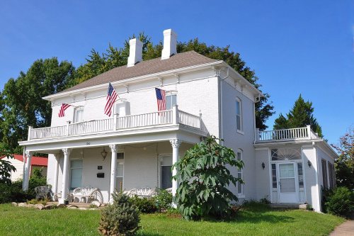
The Confederate Chapel, Cemetery and Cottage, Houx-Hoefer-Rehkop House, and Chicago and Alton Railroad Depot at Higginsville are listed on the National Register of Historic Places.
Passages that mention Higginsville, cut from the printed page as they were published.
Young's history of Lafayette County, Missouri1910Read the page →
Read the text
It may be said in passing that the first church here of this denomination was erected of frame in 1885 and it was destroyed by the cyclone soon afterwards, and that part of the lumber not ruined wras sent to be stored in and near the Catholic church at Higginsville, and when that church was burned this lumber went along with the rest. After this for a number of years this church was cared for by the visiting fathers of the Franciscan order at Higginsville, until the date of reorganization as above indicated, 1905.
Text read by machine from the scan; it may contain errors.
Young's history of Lafayette County, Missouri1910 · page 348Read the page →
Read the text
Higginsville, the only incorporation within Davis township, is beautifully situated on the Chicago & Alton and Missouri Pacific railroad lines, on sections 1 and 6, township 49, ranges 25 and 26. It was platted, as seen by the county plat books, by Henry and Carrie Higgins (from whom the place derived its name), August 14, 1869. In 1900 the federal census gave it a population of two thousand seven hundred and ninety-one.
Text read by machine from the scan; it may contain errors.
Scans and text from the Internet Archive. Books published in 1930 or earlier, which are in the public domain.
Timeline
Higginsville, 1869 to 1950
Woven from the archive, old maps, post office records, the National Register and the people born here.
Higginsville’s post office has been open since 1870.
Gone or out of use
Douglas SchoolschoolEmerson SchoolschoolIrving Schoolschool
2cemeteries and burying grounds inside Higginsville
CityMissouri State Veterans Cemetery - Higginsville
US Post Offices dataset (Blevins & Helbock, CC0). Places and cemeteries from the USGS Geographic Names Information System (2021).
Questions about Higginsville’s history
What year was Higginsville founded?
In 1869, according to Wikidata and Wikipedia’s history of the town. Higginsville’s post office opened in 1870, and the census of 1880 counted 797 people here.
How does Higginsville rank for history?
Higginsville is more historic than 56% of U.S. towns, #107 of 247 in Missouri. The History grade combines the town’s founding era, the share of homes built before 1940 and its National Register listings. It’s a character grade, so it isn’t part of the overall grade. How it works.
What is on the National Register in Higginsville?
4 listings: 4 buildings, among them the Confederate Chapel, Cemetery and Cottage (listed 1981, the first). 5 historic buildings in all.
How old are the homes in Higginsville?
12% of Higginsville’s homes were built before 1940 (Census estimate, ±4.2 points), against a typical 8.4% for a Missouri town; the median home was built in 1970.
Founding dates: Wikidata, Wikipedia, the U.S. post office records of Blevins & Helbock (CC0) and the Census. Homes by year built: Census ACS 2020–24. National Register of Historic Places: National Park Service (list of May 22, 2026). Old photos, postcards and papers: Wikimedia Commons, the Library of Congress and other public archives, credited on each item’s page. Maps: U.S. Geological Survey historical topographic maps (via Esri) and Sanborn fire-insurance maps (Library of Congress). History text and census tables: Wikipedia (CC BY-SA 4.0). Places that used to be: USGS Geographic Names Information System (2021).
From Wikimedia Commons (1), Wikidata (2), the National Register of Historic Places (4), Wikipedia, Wikidata and Wikipedia for famous people, U.S. Geological Survey historical maps, U.S. Census counts (via Wikipedia), the US Post Offices dataset (Blevins & Helbock), the USGS Geographic Names Information System, Sanborn fire insurance maps (Library of Congress) and old county and town histories (Internet Archive). Archive images are copied here with their credits and licenses, shown on each photo’s page. Refreshed monthly.


 2006