Harrisburg’s post office opened in 1871, and 1 of its places is on the National Register
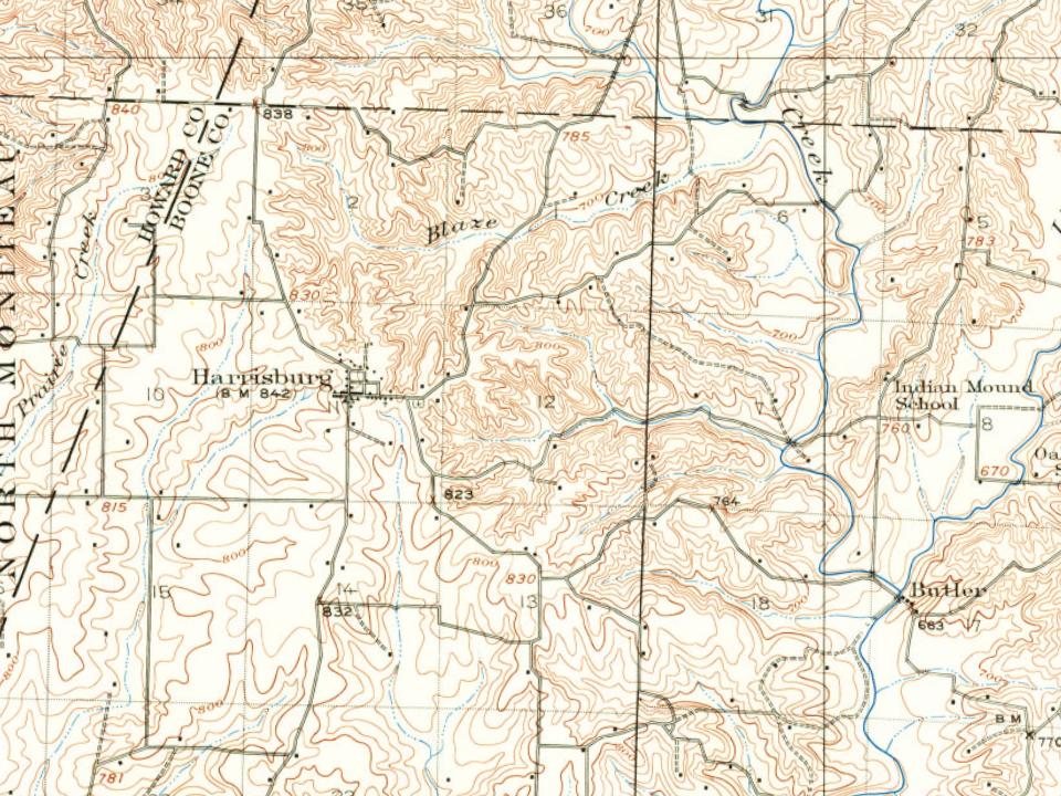
Its Register listing is the Harrisburg School-Ancient Landmark Masonic Lodge Number 356 A.F. & A.M.. Most of Harrisburg was built recently: 1% of its homes predate 1940 and the median home dates from 1993. Below: maps from 1917 on and the census since 1880.
Harrisburg was named for John W. Harris, who inherited the Model Farm on what was Thrall's Prairie, the first permanent settlement in the county. The town was laid out on the survey line of the prospective Louisiana and Missouri River Railroad which was later leased to Chicago and Alton Railroad. The line was graded and prepared, but was abandoned for a line farther north. The proposed line can be seen on the 1969 USGS topographic map of Harrisburg. According to Colonel W. F. Switzler, in 1882, there were a post office, three stores, a confectionary shop, a church, a mill, a blacksmith shop, and a public school building with the Masonic lodge above. That Harrisburg School building, constructed by the Freemasons, served as Harrisburg’s school and community center from 1878 to 1963. In 2013 it was placed on the National Register of Historic Places, but was shortly afterward demolished due…
Passages that mention Harrisburg, cut from the printed page as they were published.
History of Boone County, Missouri. Written and comp. from the most authentic official and private sources1882 · page 1073Read the page →
Read the text
Harrisburg, situated on the northwest quarter of section 11, township 50, range 14, in the northwest corner of the township, was named in honor of John W. Harris, deceased, late proprietor of the Model Farm. It was laid off soon after the survey of the Chicago and Alton railroad, and gave promise of soon becoming a town of considerable Importance. Work was actively going on all along the line of the proposed railroad, which was actually graded and made ready for the rails. The town prospered in anticipation of the early completion of
Text read by machine from the scan; it may contain errors.
History of Boone County, Missouri. Written and comp. from the most authentic official and private sources1882 · page 502Read the page →
Read the text
Previously, however, the railroad company located its road from Mexico via Hallsville and Harrisburg, through the townships named to Fayette, in Howard county, and proceeded to grade and bridge the track, but the road was never completed, and, perhaps never will be.
Text read by machine from the scan; it may contain errors.
The bench and bar of Boone County, Missouri1916 · page 76Read the page →
Read the text
as in the building used by the Sturgeon court of common pleas, in justice of the peace offices and in many of the school houses of the county. The opera houses at Ashland, Rocheport and Centralia have often been used ; and the shade trees of Harrisburg, Deer Park, Engle¬ wood, Brown Station and Jacob's pasture have furnished temporary quarters for litigants and attorneys in warm weather.
Text read by machine from the scan; it may contain errors.
Scans and text from the Internet Archive. Books published in 1930 or earlier, which are in the public domain.
By decade
No old photos in the archives yet
Weddings on Main Street, storms, parades, school pictures, the old store. If it’s in your family album, it belongs here.
Be the first to add onePhotograph a print flat, in daylight, no flash.
Founding dates: Wikidata, Wikipedia, the U.S. post office records of Blevins & Helbock (CC0) and the Census. Homes by year built: Census ACS 2020–24. National Register of Historic Places: National Park Service (list of May 22, 2026). Old photos, postcards and papers: Wikimedia Commons, the Library of Congress and other public archives, credited on each item’s page. Maps: U.S. Geological Survey historical topographic maps (via Esri) and Sanborn fire-insurance maps (Library of Congress). History text and census tables: Wikipedia (CC BY-SA 4.0). Places that used to be: USGS Geographic Names Information System (2021). How TownRatings grades history →
From Wikidata (1), the National Register of Historic Places (1), Wikipedia, U.S. Geological Survey historical maps, U.S. Census counts (via Wikipedia), the US Post Offices dataset (Blevins & Helbock), the USGS Geographic Names Information System and old county and town histories (Internet Archive). Archive images are copied here with their credits and licenses, shown on each photo’s page. Refreshed monthly.