Most of Chain of Rocks was built recently: 9% of its homes predate 1940 and the median home dates from 2001. Below: 1 old photo or paper, maps from 1941 on, and the census since 2000.
Chain of Rocks was platted in the 1830s, and named for a rock formation near the original town site. A post office called Chain of Rocks was established in 1869, and remained in operation until 1907.
Passages that mention Chain of Rocks, cut from the printed page as they were published.
History of Lincoln County, Missouri, from the earliest time to the present1888 · page 295Read the page →
Read the text
This subscription was made on the condition that the railroad should commence on the North Missouri Railroad, at or near Dardenne, thence to cross the Cuivre at or near Chain of Rocks, and thence to re-cross the Cuivre at or near Moscow, and pass up the west side of the river within one-half of a mile from the courthouse in Troy, and thence northwardly, passing near Auburn, or between Auburn and New Hope, on the most eligible ground to the Pike County line. And for the purpose of carrying
Text read by machine from the scan; it may contain errors.
History of Lincoln County, Missouri, from the earliest time to the present1888 · page 330Read the page →
Read the text
Chain of Rocks 66 28 Chantilla 46 29 Winfleld 62 70 Burr Oak Valley 42 123 Brussells r 20 101 :hewHope 69 53 Elsberry 99 125 Smith's Schoolhouse 25 19
Text read by machine from the scan; it may contain errors.
Scans and text from the Internet Archive. Books published in 1930 or earlier, which are in the public domain.
Timeline
Chain of Rocks, 1869 to 1941
Woven from the archive, old maps, post office records, the National Register and the people born here.
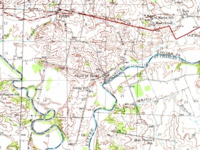
Every edition of the U.S. Geological Survey’s map of Chain of Rocks. Tap a year, or press play to watch the town change.
1941Troy sheet · 1:62,500
U.S. Geological Survey historical topographic maps (public domain), via Esri’s collection of the scans. The red ring marks the center of Chain of Rocks.
Then & now
Stand where they stood
No then-and-now pairs yet. Take a photo from the same spot as an old one and they appear here side by side.
Retake this viewChain of Rocks Bridge, Spanning Ciuvre River at County Road 899
Find the spot, match the angle, and add your photo. It becomes the first then-and-now pair on Chain of Rocks’ page.
Founding dates: Wikidata, Wikipedia, the U.S. post office records of Blevins & Helbock (CC0) and the Census. Homes by year built: Census ACS 2020–24. National Register of Historic Places: National Park Service (list of May 22, 2026). Old photos, postcards and papers: Wikimedia Commons, the Library of Congress and other public archives, credited on each item’s page. Maps: U.S. Geological Survey historical topographic maps (via Esri) and Sanborn fire-insurance maps (Library of Congress). History text and census tables: Wikipedia (CC BY-SA 4.0). Places that used to be: USGS Geographic Names Information System (2021). How TownRatings grades history →
From the Library of Congress (1), Wikipedia, U.S. Geological Survey historical maps, U.S. Census counts (via Wikipedia), the US Post Offices dataset (Blevins & Helbock), the USGS Geographic Names Information System and old county and town histories (Internet Archive). Archive images are copied here with their credits and licenses, shown on each photo’s page. Refreshed monthly.


 Date?


