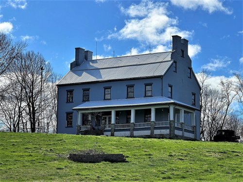
Bethel dates to 1844, and 64% of its homes were built before 1940
3 places in town are on the National Register, among them a historic district with 18 buildings. Below: 7 old photos and papers, maps from 1953 on, and the census since 1880.
Bethel was founded as a Bible utopian colony in 1844 by Dr William Keil (1811–1877), a Prussian-born preacher. He and his followers, who were almost exclusively German immigrants to America, believed that the Book of Acts required that Christians hold all property and means of production in common and they organized their Colony accordingly. Traditionally male work was communally performed; however, traditionally female work was still individualized and performed in single family households.
Passages that mention Bethel, cut from the printed page as they were published.
General history of Shelby County, Missouri1911 · page 40Read the page →
Read the text
there throughout the county, but at this time the colony had planned for a settlement to themselves, and so laid out and established the town of Bethel, which we take up later in the history of Bethel, These progressive people also entered a considerable government land.
Text read by machine from the scan; it may contain errors.
General history of Shelby County, Missouri1911 · page 357Read the page →
Read the text
cated in his native land, whence he immigrated to America as a young man. In 1845 he became a member of the German colony founded at Bethel, Shelby county, Missouri, and he became one of the prosperous farmers and stock growers of the county, having continued his residence in the village of Bethel until the disband-
Text read by machine from the scan; it may contain errors.
Scans and text from the Internet Archive. Books published in 1930 or earlier, which are in the public domain.
Timeline
Bethel, 1844 to 1953
Woven from the archive, old maps, post office records, the National Register and the people born here.
National Park Service, National Register of Historic Places. Photos from Wikimedia Commons, credited on each place’s page.
Questions about Bethel’s history
What year was Bethel founded?
In 1844, according to Wikidata and Wikipedia’s history of the town. Bethel’s post office opened in 1848, and the census of 1880 counted 184 people here.
What is on the National Register in Bethel?
Three places: the Elim (listed 1971), the Bethel Historic District (1970) and the Hebron (1978).
Founding dates: Wikidata, Wikipedia, the U.S. post office records of Blevins & Helbock (CC0) and the Census. Homes by year built: Census ACS 2020–24. National Register of Historic Places: National Park Service (list of May 22, 2026). Old photos, postcards and papers: Wikimedia Commons, the Library of Congress and other public archives, credited on each item’s page. Maps: U.S. Geological Survey historical topographic maps (via Esri) and Sanborn fire-insurance maps (Library of Congress). History text and census tables: Wikipedia (CC BY-SA 4.0). Places that used to be: USGS Geographic Names Information System (2021). How TownRatings grades history →
From Wikimedia Commons (2), the Library of Congress (7), the National Register of Historic Places (3), Wikipedia, U.S. Geological Survey historical maps, U.S. Census counts (via Wikipedia), the US Post Offices dataset (Blevins & Helbock), the USGS Geographic Names Information System and old county and town histories (Internet Archive). Archive images are copied here with their credits and licenses, shown on each photo’s page. Refreshed monthly.


 Date?
 Date?
 Date?
 Date?
 Date?
 Date?
 Date?
 2023
 2004