Founding year: the first Anderson post office (Blevins & Helbock, CC0).The full story ↓
History grade
What drives Anderson’s History grade
On its age, its old homes and the National Register, Anderson is more historic than 29% of U.S. towns. Its share of homes from before 1940 holds the grade up; its National Register listings pull it down.
C
HistoryA character grade: shown, never part of Anderson’s overall grade.
Missouri towns list about as much on the Register as the country (a typical Missouri town has 2.4 per 10,000 residents, the U.S. 2.4), so Anderson’s 0.0 sits below most of its state (23% of Missouri towns have fewer) while its 0 listings outnumber those of 23% of U.S. towns.
How sure. Graded on any two of the three inputs instead, the letter would range from C− to C+. The pre-1940 share is a Census survey estimate (±6.2 points). The founding year is the first post office, not a stated founding date.
Founding year: the first post office (other dates in Quick answers). Homes: Census ACS 2020–24. National Register: National Park Service, May 2026 list; each listing counted once (boundary changes and added documentation belong to their listing), and a historic district counts its contributing buildings. How TownRatings grades history →
What stands out about Anderson’s past
Read from the archive, the National Register and the record. The page puts what stands out first.
Passages that mention Anderson, cut from the printed page as they were published.
Noted guerrillas, or The warfare of the border. Being a history of the lives and adventures of Quantrell, Bill Anderson, George Todd, Dave Poole, Fletcher Taylor, Peyton Long, Oll Shepherd, Arch Clements, John Maupin, Tuck and Woot Hill, Wm. Gregg, Thomas1879 · page 242Read the page →
Read the text
Frank James commanded the company, and gave it up to Anderson as soon as Anderson arrived within commanding distance, the aggregated column amounting to sixty-five rank and'fi!e. The march, begun on the morning of August 12th, 1874, was interrupted the same evening by an attack from seventyfive militia, near Fredericksburg, Ray county, who fought for a few moments as if they meant business, but Anderson's charge, led by such splendid pistol fighters as James Commons, Arch
Text read by machine from the scan; it may contain errors.
Illustrated history of McDonald County, Missouri1897 · page 9Read the page →
Read the text
from John Patterson, an old bachelor who settled on the creek about the year 1833. The creek rises about two miles west of the town of Anderson and runs principally west, passing into the Territory about a mile south of Tiff City. South Indian creek takes its source at a large spring in the town of Rocky Comfort and runs south of west for some ten or twelve miles where
Text read by machine from the scan; it may contain errors.
Noted guerrillas, or The warfare of the border. Being a history of the lives and adventures of Quantrell, Bill Anderson, George Todd, Dave Poole, Fletcher Taylor, Peyton Long, Oll Shepherd, Arch Clements, John Maupin, Tuck and Woot Hill, Wm. Gregg, Thomas1879 · page 165Read the page →
Read the text
Soon a stir came along the border. A name new to the strife was beginning to pass from band to band and have about the camp fires a respectful hearing. "Anderson?" "Anderson?" "Who is this Anderson?" the Guerrillas asked one of another. "He kills them all. Quantrell spares, now and then, and Poole, and Blunt, and Yager, and Haller, and Jarrette, and Younger, and Gregg, and Todd, and Shepherd, and Cunningham, and all the balance; but Anderson never. Is he a devil in uni-
Text read by machine from the scan; it may contain errors.
Illustrated history of McDonald County, Missouri1897 · page 36Read the page →
Read the text
through and passes out on the south line a little west of the center. Beaver valley also enters near the northeast corner and empties into Indian creek just below the town of Anderson. The above-named stream meanders through the southern part of the township. The first settlement was mentioned in the chapter on Early Settlement. The principal place is Anderson,
Text read by machine from the scan; it may contain errors.
Scans and text from the Internet Archive. Books published in 1930 or earlier, which are in the public domain.
Timeline
Anderson, 1886 to 1940
Woven from the archive, old maps, post office records, the National Register and the people born here.
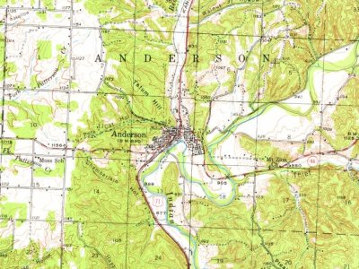
Every edition of the U.S. Geological Survey’s map of Anderson. Tap a year, or press play to watch the town change.
1940Noel sheet · 1:62,500
U.S. Geological Survey historical topographic maps (public domain), via Esri’s collection of the scans. The red ring marks the center of Anderson.
Every building
Anderson, building by building, 1920–1928
Fire insurance maps drew every building, what it was made of and what it was used for, so insurers could price the risk of fire. Pick a year, then a sheet.
1920Sheet 1 of 1
Edition
Sheets
BrickWoodStone
Sanborn Map Company, via the Library of Congress. Editions published in 1930 or earlier, which are in the public domain.
People over time
Anderson, census by census
Grew from 721 people in 1910 to 1,981 in 2020.
12 censuses, 1910–2020.
U.S. Census Bureau decennial counts, from the census table on Anderson’s Wikipedia page.
Famous people
2 famous people were born in Anderson
Writers, athletes, leaders and more, ranked by how widely they’re known.
The Anderson post office opened in 1886, the earliest record of the town by name (U.S. post office records).
How does Anderson rank for history?
Anderson is more historic than 29% of U.S. towns. The History grade combines the town’s founding era, the share of homes built before 1940 and its National Register listings. It’s a character grade, so it isn’t part of the overall grade. How it works.
How old are the homes in Anderson?
11% of Anderson’s homes were built before 1940 (Census estimate, ±6.2 points), against a typical 8.4% for a Missouri town; the median home was built in 1976.
Founding dates: Wikidata, Wikipedia, the U.S. post office records of Blevins & Helbock (CC0) and the Census. Homes by year built: Census ACS 2020–24. National Register of Historic Places: National Park Service (list of May 22, 2026). Old photos, postcards and papers: Wikimedia Commons, the Library of Congress and other public archives, credited on each item’s page. Maps: U.S. Geological Survey historical topographic maps (via Esri) and Sanborn fire-insurance maps (Library of Congress). History text and census tables: Wikipedia (CC BY-SA 4.0). Places that used to be: USGS Geographic Names Information System (2021).
From Wikimedia Commons (1), Wikipedia, Wikidata and Wikipedia for famous people, U.S. Geological Survey historical maps, U.S. Census counts (via Wikipedia), the US Post Offices dataset (Blevins & Helbock), the USGS Geographic Names Information System, Sanborn fire insurance maps (Library of Congress) and old county and town histories (Internet Archive). Archive images are copied here with their credits and licenses, shown on each photo’s page. Refreshed monthly.


 2004


