Taunton was platted in 1886 by the railroad. It was named after Taunton, Massachusetts. A post office has been in operation in Taunton since 1888. Taunton was incorporated in 1900.
Passages that mention Taunton, cut from the printed page as they were published.
An illustrated history of Lyon County, Minnesota1912 · page 216Read the page →
Read the text
of December 9, 1898. gave the following description of Taunton and its standing: In your paper of November 25 you speak of Taunton as a railroad station with but half a dozen or less buildings. You have a mistaken idea of the size of our town. Taunton has about 100 inhabitants. We have thirty business and dwelling houses; we have three firms buying
Text read by machine from the scan; it may contain errors.
An illustrated history of Lyon County, Minnesota1912 · page 215Read the page →
Read the text
The smallest of the incorporated villages of Lyon county is Taunton, ft is a station of the Northwestern railroad and is in the extreme northwestern corner of the county, on section t7, Eidsvold township. The population in 13The charter members of the Woodmen cam]) were Edward F. St. Denis; Aime Van Hee, Levi St. Peter,
Text read by machine from the scan; it may contain errors.
Scans and text from the Internet Archive. Books published in 1930 or earlier, which are in the public domain.
Timeline
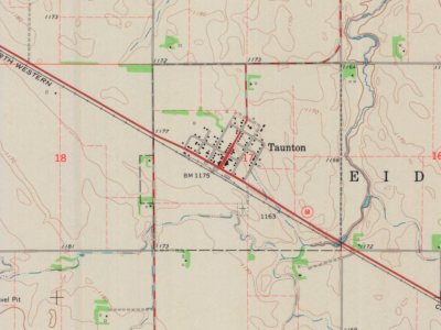
Taunton, 1886 to 1967
Woven from the archive, old maps, post office records, the National Register and the people born here.
Founding dates: Wikidata, Wikipedia, the U.S. post office records of Blevins & Helbock (CC0) and the Census. Homes by year built: Census ACS 2020–24. National Register of Historic Places: National Park Service (list of May 22, 2026). Old photos, postcards and papers: Wikimedia Commons, the Library of Congress and other public archives, credited on each item’s page. Maps: U.S. Geological Survey historical topographic maps (via Esri) and Sanborn fire-insurance maps (Library of Congress). History text and census tables: Wikipedia (CC BY-SA 4.0). Places that used to be: USGS Geographic Names Information System (2021). How TownRatings grades history →
From Wikimedia Commons (1), Wikipedia, U.S. Geological Survey historical maps, U.S. Census counts (via Wikipedia), the US Post Offices dataset (Blevins & Helbock), the USGS Geographic Names Information System and old county and town histories (Internet Archive). Archive images are copied here with their credits and licenses, shown on each photo’s page. Refreshed monthly.

![The smallest of the incorporated villages of Lyon county is Taunton, ft is a station of the Northwestern railroad and is in the extreme northwestern corner of the county, on section t7, Eidsvold township. The population in 13The charter members of the Woodmen cam]) were Edward F. St. Denis; Aime Va…](https://images.townratings.com/story/8468/bk-58235c24256efebf-l.jpg)
 2005


