Pine Island’s post office opened in 1856, and 4 of its places are on the National Register
More historic than 53% of U.S. towns · #98 of 273 in Minnesota. What drives it
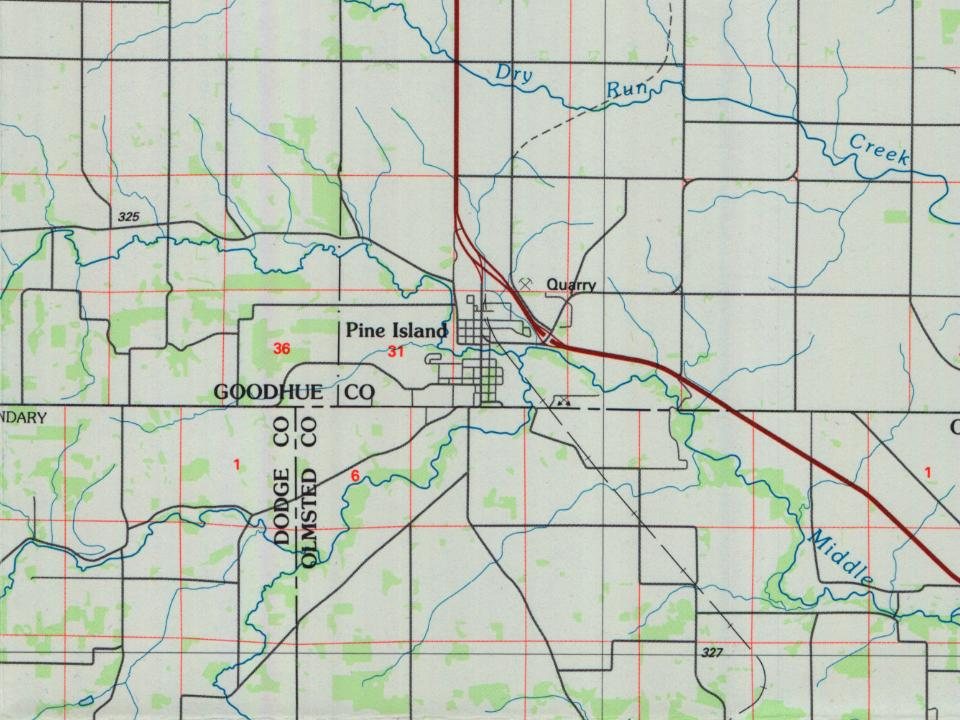
Most of Pine Island was built recently: 9% of its homes predate 1940 and the median home dates from 2001. Below: 2 old photos and papers, maps from 1965 on, and the census since 1880.
Founding year: the first Pine Island post office (Blevins & Helbock, CC0).The full story ↓
History grade
What drives Pine Island’s History grade
On its age, its old homes and the National Register, Pine Island is more historic than 53% of U.S. towns, #98 of 273 in Minnesota. Its National Register listings hold the grade up; its age pulls it down.
B−
HistoryA character grade: shown, never part of Pine Island’s overall grade.
Minnesota towns list about as much on the Register as the country (a typical Minnesota town has 2.1 per 10,000 residents, the U.S. 2.4), so Pine Island’s 11.2 sits above most of its state (78% of Minnesota towns have fewer) while its 4 listings outnumber those of 68% of U.S. towns.
How sure. Graded on any two of the three inputs instead, the letter would range from C to B. The pre-1940 share is a Census survey estimate (±8.3 points). The founding year is the first post office, not a stated founding date.
Founding year: the first post office (other dates in Quick answers). Homes: Census ACS 2020–24. National Register: National Park Service, May 2026 list; each listing counted once (boundary changes and added documentation belong to their listing), and a historic district counts its contributing buildings. How TownRatings grades history →
What stands out about Pine Island’s past
Read from the archive, the National Register and the record. The page puts what stands out first.
Pine Island was platted in 1856. A post office has been in operation at Pine Island since 1856. The name of the town originates from an ancient Dakota language name Wazi Wíta (Island of Pines) originating from a cluster of pine trees at a bend in the river on the site of the modern-day town.
Passages that mention Pine Island, cut from the printed page as they were published.
History of Goodhue County, Minnesota1909 · page 807Read the page →
Read the text
John Ihrke. a prosperous farmer of Pine Island township, was horn in Fond du Lac comity, Wisconsin, July 28, 1864, son of John and Richie (Miller) Ihrke, natives of Germany, who came to America in 1864 and located in Wisconsin. In 1875 they came to Minnesota, located in the township of Pine Island, and engaged in farming, until the death of the father, February 9, 1901, the mother having passed away in 1867. John attended the common schools and worked with his father. In 1885 he came to the farm,
Text read by machine from the scan; it may contain errors.
History of Goodhue county, including a sketch of the territory and state of Minnesota1878 · page 479Read the page →
Read the text
The first settler in the township of Pine Island was Josiah Haggard, a youth. of nineteen or twenty summers, who located his claim near the present residence of Dr. Chas. Hill, in the spring of 1854. • This claim was jumped by a man named Howard, who came in soon after, when Haggard crossed the Zumbro and made the second claim, now occupied by the dwellings and business houses of this growing populace. Here he had partially established himself with a half-built log habitation, when Moses Jewell and son, Solomon, came in the fall of 1855, and
Text read by machine from the scan; it may contain errors.
History of Goodhue County, Minnesota1909 · page 310Read the page →
Read the text
Pine Island. — The post-office at Pine Island was established in 1856, with John Chance as postmaster. He served two years. The first mail supply was by the Burbank stage line between Dubuque and St. Paul. When this supply was discontinued the office was put on the Red Wing and Mantorville star route, from which it received service until 1878, when the building of the Chicago & Northwestern branch from Rochester to Zumbrota enabled the establishing of railway mail service. The office is
Text read by machine from the scan; it may contain errors.
History of Goodhue county, including a sketch of the territory and state of Minnesota1878 · page 645Read the page →
Read the text
settled in the village of Pine Island. 1864, enlisted in the 11th Minn. V., Co. D, ; served until the close of the war, most of the time stationed at Nashville. Returned to this village in 1865, and worked at his trade.
Text read by machine from the scan; it may contain errors.
Scans and text from the Internet Archive. Books published in 1930 or earlier, which are in the public domain.
Timeline
Pine Island, 1856 to 1965
Woven from the archive, old maps, post office records, the National Register and the people born here.
Nothing in the archives for these yearsWeddings on Main Street, storms, parades, school pictures, the old store. If it’s in your family album, it belongs here.
The Pine Island post office opened in 1856, the earliest record of the town by name (U.S. post office records).
How does Pine Island rank for history?
Pine Island is more historic than 53% of U.S. towns, #98 of 273 in Minnesota. The History grade combines the town’s founding era, the share of homes built before 1940 and its National Register listings. It’s a character grade, so it isn’t part of the overall grade. How it works.
What is on the National Register in Pine Island?
4 listings: 4 buildings, among them the Bank of Pine Island, Opera House Block (listed 1980, the first).
How old are the homes in Pine Island?
9% of Pine Island’s homes were built before 1940 (Census estimate, ±8.3 points), against a typical 8.1% for a Minnesota town; the median home was built in 2001.
Founding dates: Wikidata, Wikipedia, the U.S. post office records of Blevins & Helbock (CC0) and the Census. Homes by year built: Census ACS 2020–24. National Register of Historic Places: National Park Service (list of May 22, 2026). Old photos, postcards and papers: Wikimedia Commons, the Library of Congress and other public archives, credited on each item’s page. Maps: U.S. Geological Survey historical topographic maps (via Esri) and Sanborn fire-insurance maps (Library of Congress). History text and census tables: Wikipedia (CC BY-SA 4.0). Places that used to be: USGS Geographic Names Information System (2021).
From Wikimedia Commons (4), the Library of Congress (2), the National Register of Historic Places (4), Wikipedia, Wikidata and Wikipedia for famous people, U.S. Geological Survey historical maps, U.S. Census counts (via Wikipedia), the US Post Offices dataset (Blevins & Helbock), the USGS Geographic Names Information System and old county and town histories (Internet Archive). Archive images are copied here with their credits and licenses, shown on each photo’s page. Refreshed monthly.




 1909
 2009
 2009
 2009
 2005