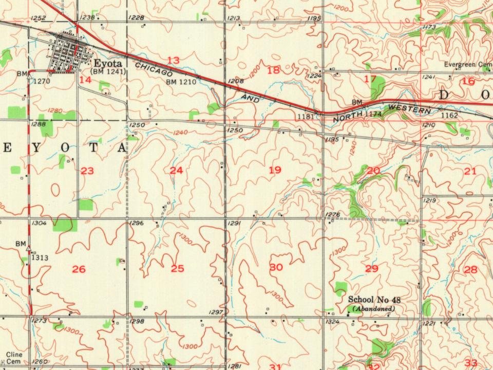
The Eyota post office opened in 1864, the earliest record of the town by name. Another post office, Greenfield (1857), opened inside today’s city and later closed.
First census: 404 in 18802020 census: 2,006162 years
How historic is Eyota?
B−
More historic than 53% of U.S. towns, on its age, its old homes and the National Register.
Founding year: the first Eyota post office (Blevins & Helbock, CC0).The full story ↓
History grade
What drives Eyota’s History grade
On its age, its old homes and the National Register, Eyota is more historic than 53% of U.S. towns. Its National Register listings hold the grade up; its age pulls it down.
B−
HistoryA character grade: shown, never part of Eyota’s overall grade.
Minnesota towns list about as much on the Register as the country (a typical Minnesota town has 2.1 per 10,000 residents, the U.S. 2.4), so Eyota’s 10.3 sits above most of its state (77% of Minnesota towns have fewer) while its 2 listings outnumber those of 60% of U.S. towns.
How sure. Graded on any two of the three inputs instead, the letter would range from C+ to B. The pre-1940 share is a Census survey estimate (±4.4 points). The founding year is the first post office, not a stated founding date.
Founding year: the first post office (other dates in Quick answers). Homes: Census ACS 2020–24. National Register: National Park Service, May 2026 list; each listing counted once (boundary changes and added documentation belong to their listing), and a historic district counts its contributing buildings. How TownRatings grades history →
What stands out about Eyota’s past
Read from the archive, the National Register and the record. The page puts what stands out first.
Eyota was platted in 1864. The name Eyota is derived from the Dakota word iyótaŋ, meaning "greatest" or "most". A post office has been in operation at Eyota since 1864. The city was incorporated on February 16, 1875.
Settlers had begun arriving in the area and staking claims in 1854. The earliest, Benjamin Bear, initially came in 1853 to choose a prime site with an ever-flowing spring, then returned the following year with his family. A stream called Bear Creek starts from this spring. (Today Chester Woods Lake is formed around a portion of Bear Creek that was held back behind a dam built to protect nearby Rochester from flooding.)
Passages that mention Eyota, cut from the printed page as they were published.
History of Olmsted County, Minnesota1910 · page 417Read the page →
Read the text
the state of New York, U. S. A., respectively, the former parent dying at Omaha, Nebraska, April 22, 1908. He came to Minnesota in October, 1858, and pre-empted a farm on section 24, in the township of Eyota, Olmsted County, where, on May 8, 1865, the subject of this sketch was bom, who, with the exception of about three years, has since resided within Olmsted county. In the early seventies his parents moved to the village of Dover, where they resided several years, after which they moved to the village
Text read by machine from the scan; it may contain errors.
History of Olmsted County, Minnesota1910 · page 297Read the page →
Read the text
Village of Viola. — When the railroad from Eyota to Plainview was built through Viola township, a station was established with a grain elevator and the village of Viola was platted in September, 1878. It is located in a beautiful valley surrounded by rich farms and is a thriving little village. The population of the village comprises about fifteen families.
Text read by machine from the scan; it may contain errors.
Scans and text from the Internet Archive. Books published in 1930 or earlier, which are in the public domain.
Timeline
Eyota, 1857 to 1954
Woven from the archive, old maps, post office records, the National Register and the people born here.
National Park Service, National Register of Historic Places. Photos from Wikimedia Commons, credited on each place’s page.
People over time
Eyota, census by census
Grew from 404 people in 1880 to 2,006 in 2020, 4 times over.
15 censuses, 1880–2020.
U.S. Census Bureau decennial counts, from the census table on Eyota’s Wikipedia page.
Places that used to be
Lost post offices
Eyota’s post office has been open since 1864. Another post office, Greenfield, opened and closed inside today’s town.
Greenfield
1857–1864
Eyota
1864–today
18501940today
US Post Offices dataset (Blevins & Helbock, CC0). Places and cemeteries from the USGS Geographic Names Information System (2021).
Questions about Eyota’s history
What year was Eyota founded?
The Eyota post office opened in 1864, the earliest record of the town by name (U.S. post office records).
How does Eyota rank for history?
Eyota is more historic than 53% of U.S. towns. The History grade combines the town’s founding era, the share of homes built before 1940 and its National Register listings. It’s a character grade, so it isn’t part of the overall grade. How it works.
What is on the National Register in Eyota?
Two places: the Coan House (listed 1980) and the Eyota Farmers Cooperative Creamery Association (1980).
How old are the homes in Eyota?
11% of Eyota’s homes were built before 1940 (Census estimate, ±4.4 points), against a typical 8.1% for a Minnesota town; the median home was built in 1980.
Founding dates: Wikidata, Wikipedia, the U.S. post office records of Blevins & Helbock (CC0) and the Census. Homes by year built: Census ACS 2020–24. National Register of Historic Places: National Park Service (list of May 22, 2026). Old photos, postcards and papers: Wikimedia Commons, the Library of Congress and other public archives, credited on each item’s page. Maps: U.S. Geological Survey historical topographic maps (via Esri) and Sanborn fire-insurance maps (Library of Congress). History text and census tables: Wikipedia (CC BY-SA 4.0). Places that used to be: USGS Geographic Names Information System (2021).
From Wikimedia Commons (10), Wikidata (2), the National Register of Historic Places (2), Wikipedia, Wikidata and Wikipedia for famous people, U.S. Geological Survey historical maps, U.S. Census counts (via Wikipedia), the US Post Offices dataset (Blevins & Helbock), the USGS Geographic Names Information System and old county and town histories (Internet Archive). Archive images are copied here with their credits and licenses, shown on each photo’s page. Refreshed monthly.


 2024
 2024
 2024
 2024
 2019
 2013
 2010
 2008
 2008
 2005