Founding year: Wikipedia. First post office: 1859.The full story ↓
History grade
What drives Dundas’ History grade
On its age, its old homes and the National Register, Dundas is more historic than 59% of U.S. towns. Its National Register listings hold the grade up; its age pulls it down.
B
HistoryA character grade: shown, never part of Dundas’ overall grade.
Minnesota towns list about as much on the Register as the country (a typical Minnesota town has 2.1 per 10,000 residents, the U.S. 2.4), so Dundas’ 26.1 sits above most of its state (87% of Minnesota towns have fewer) while its 5 listings outnumber those of 70% of U.S. towns.
How sure. Graded on any two of the three inputs instead, the letter would range from C+ to B+. The pre-1940 share is a Census survey estimate (±4.3 points). Two sources give 1857.
Founding year: Wikipedia (other dates in Quick answers). Homes: Census ACS 2020–24. National Register: National Park Service, May 2026 list; each listing counted once (boundary changes and added documentation belong to their listing), and a historic district counts its contributing buildings. How TownRatings grades history →
What stands out about Dundas’ past
Read from the archive, the National Register and the record. The page puts what stands out first.
Dundas was platted in 1857 by the Archibalds: brothers John Sidney and Edward T., along with their cousin George Archibald, who built mills on both sides of the Cannon River. The brothers named the city after their home Dundas County, Ontario, Canada.
In 1857, the Archibalds founded the Archibald Mill, a flour mill, on the west bank of the Cannon River. The milling industry contributed greatly to Dundas' 19th-century success, and at one point the mills in Dundas were considered among the best in the world. The ruins of the Archibald Mill can still be seen today.
Tlie first town meeting ot Bridgewater, for the purpose of organizing the township, was held on the 11th of May, 1858, at the house of Fernando Thompson in the village of Dundas. The meeting was called to order and 0. C. Stetson was chosen chairman, pro Urn., and Benjamin Lockerby, moderator. They next proceeded to ballot for officers, which resulted as follows: Supervisors, Benjamin
Text read by machine from the scan; it may contain errors.
History of Rice County, including explorers and pioneers of Minnesota and outline history of the state of Minnesota1882 · page 442Read the page →
Read the text
The first town meeting of Bridgewater, for the purpose of organizing the township, was held on the 11th of May, 1858, at the house of Fernando Thompson in the village of Dundas. The meeting was called to order and C. C. Stetson was chosen chairman, pro tern., and Benjamin Lockerby, moderator. They next proceeded to ballot for officers, which resulted as follows: Supervisors, Benjamin
Text read by machine from the scan; it may contain errors.
ural surface, where the railroad crosses the northern line of the county, to be over 11150 feet above the sea level. At Faribault dejjot it is 993 feet; at Dundas depot, 94.5 feet; at Northfield depot, 90.5 feet. The entire western half, and the southeastern portions of the county, have a higher elevation. I have no means of knowing positively the relative elevations or the_highest point in tlie
Text read by machine from the scan; it may contain errors.
History of Rice County, including explorers and pioneers of Minnesota and outline history of the state of Minnesota1882 · page 287Read the page →
Read the text
On the 15th of September, the committee appointed to consider a petition for assistance in building a bridge at Dundas, reported that they did not consider the county ihiances in shape, nor able to assist in building the bridge. The petition was therefore tabled. At the same meeting a note was presented by Nicholls & Buckley, which had been given by the board, but could not be
Text read by machine from the scan; it may contain errors.
Scans and text from the Internet Archive. Books published in 1930 or earlier, which are in the public domain.
Timeline
Dundas, 1857 to 2020
Woven from the archive, old maps, post office records, the National Register and the people born here.
In 1857, according to Wikipedia’s history of the town. Dundas’ post office opened in 1859, and the census of 1880 counted 589 people here.
How does Dundas rank for history?
Dundas is more historic than 59% of U.S. towns. The History grade combines the town’s founding era, the share of homes built before 1940 and its National Register listings. It’s a character grade, so it isn’t part of the overall grade. How it works.
What is on the National Register in Dundas?
5 listings: 4 buildings, among them the Edward T. Archibald House (listed 1976, the first), and 1 site.
How old are the homes in Dundas?
11% of Dundas’ homes were built before 1940 (Census estimate, ±4.3 points), against a typical 8.1% for a Minnesota town; the median home was built in 2003.
Founding dates: Wikidata, Wikipedia, the U.S. post office records of Blevins & Helbock (CC0) and the Census. Homes by year built: Census ACS 2020–24. National Register of Historic Places: National Park Service (list of May 22, 2026). Old photos, postcards and papers: Wikimedia Commons, the Library of Congress and other public archives, credited on each item’s page. Maps: U.S. Geological Survey historical topographic maps (via Esri) and Sanborn fire-insurance maps (Library of Congress). History text and census tables: Wikipedia (CC BY-SA 4.0). Places that used to be: USGS Geographic Names Information System (2021).
From Wikimedia Commons (7), Wikidata (5), the National Register of Historic Places (5), Wikipedia, Wikidata and Wikipedia for famous people, U.S. Geological Survey historical maps, U.S. Census counts (via Wikipedia), the US Post Offices dataset (Blevins & Helbock), the USGS Geographic Names Information System and old county and town histories (Internet Archive). Archive images are copied here with their credits and licenses, shown on each photo’s page. Refreshed monthly.


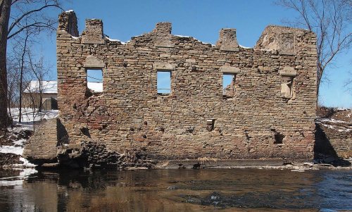


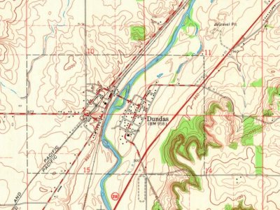
 2015
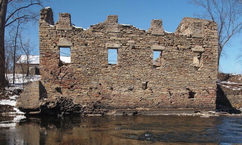 2015
 2010
 2008
 2008
 2008

