Ypsilanti dates to 1823, and 32% of its homes were built before 1940
More historic than 97% of U.S. towns · #16 of 701 in Michigan. What drives it
8 places in town are on the National Register, among them three historic districts with 816 buildings between them. Below: 18 old photos and papers, maps from 1888 on, and the census since 1860.
On its age, its old homes and the National Register, Ypsilanti is more historic than 97% of U.S. towns, #16 of 701 in Michigan. All 3 inputs are above most U.S. towns; its National Register listings ranks highest and its age lowest.
A+
HistoryA character grade: shown, never part of Ypsilanti’s overall grade.
Few Michigan towns list much on the Register (a typical Michigan town has 0.0 per 10,000 residents, the U.S. 2.4), so Ypsilanti’s 413 sits above most of its state (98% of Michigan towns have fewer) while its 820 historic buildings outnumber those of 98% of U.S. towns.
NoteThe founding year comes from Wikidata alone; no second source gives 1823.
How sure. Graded on any two of the three inputs instead, the letter would range from A to A+. The pre-1940 share is a Census survey estimate (±4.0 points).
Founding year: Wikidata (other dates in Quick answers). Homes: Census ACS 2020–24. National Register: National Park Service, May 2026 list; each listing counted once (boundary changes and added documentation belong to their listing), and a historic district counts its contributing buildings. How TownRatings grades history →
What stands out about Ypsilanti’s past
Read from the archive, the National Register and the record. The page puts what stands out first.
Nothing in the archives for these yearsWeddings on Main Street, storms, parades, school pictures, the old store. If it’s in your family album, it belongs here.
Originally a trading post established in 1809 by a French-Canadian fur trader from Montreal, a permanent settlement was established on the east side of the Huron River in 1823 by Major Thomas Woodruff. It was incorporated into the Territory of Michigan as the village Woodruff's Grove. A separate community a short distance away on the west side of the river was established in 1825 under the name "Ypsilanti", after Demetrios Ypsilantis, a hero in the Greek War of Independence. Woodruff's Grove changed its name to Ypsilanti in 1829, the year its namesake effectively won the war for Greek Independence at the Battle of Petra, with the two communities eventually merging. A bust of Demetrios Ypsilantis by Greek sculptor Christopher Nastos stands between a Greek and a US flag at the base of the landmark Ypsilanti Water Tower.
Passages that mention Ypsilanti, cut from the printed page as they were published.
History of Washtenaw County, Michigan1881 · page 161Read the page →
Read the text
the county is a well-marked ridge of gravel, readily distinguished from the ordinary less continuous accumulations of the Modified Drift, which marks, iindoubtedly, an ancient shore line. It enters the county from the north, in the northwestern corner of Ypsilanti, and crossing the Huron river a couple of miles east of the village of Ypsilanti, traverses sections 5, 6 and 7 of Augiista, entering York in section 15, passing the village of Mooreville, and leaving the county at the southwest corner of section 32, York. We may
Text read by machine from the scan; it may contain errors.
History of Washtenaw County, Michigan1881 · page 125Read the page →
Read the text
tlers followed the Indian trails, or paths, blazed by themselves through the forests. In 1825, Orange Eisdon surveyed the road from Detroit to Chicago, entering Washtenaw county on section 1, in the town of Ypsilanti, taking a southwest course and passing through the towns of Ypsilanti, Pittsfield, Saline and Bridgewater, and passing out of the county from section 33 in the latter town.
Text read by machine from the scan; it may contain errors.
Scans and text from the Internet Archive. Books published in 1930 or earlier, which are in the public domain.
Timeline
Ypsilanti, 1823 to 2005
Woven from the archive, old maps, post office records, the National Register and the people born here.
Fire insurance maps drew every building, what it was made of and what it was used for, so insurers could price the risk of fire. Pick a year, then a sheet.
In 1823, according to Wikidata. the census of 1860 counted 3,955 people here.
How does Ypsilanti rank for history?
Ypsilanti is more historic than 97% of U.S. towns, #16 of 701 in Michigan. The History grade combines the town’s founding era, the share of homes built before 1940 and its National Register listings. It’s a character grade, so it isn’t part of the overall grade. How it works.
What is on the National Register in Ypsilanti?
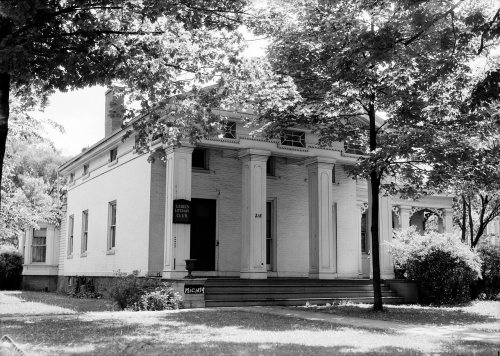
8 listings: 4 buildings, among them the Ladies' Literary Club Building (listed 1972, the first), 3 historic districts, the Ypsilanti Historic District, the Eastern Michigan University Historic District and the Highland Cemetery, with 816 contributing buildings, and 1 structure. 820 historic buildings in all.
How old are the homes in Ypsilanti?
32% of Ypsilanti’s homes were built before 1940 (Census estimate, ±4.0 points), against a typical 12% for a Michigan town; the median home was built in 1956.
Founding dates: Wikidata, Wikipedia, the U.S. post office records of Blevins & Helbock (CC0) and the Census. Homes by year built: Census ACS 2020–24. National Register of Historic Places: National Park Service (list of May 22, 2026). Old photos, postcards and papers: Wikimedia Commons, the Library of Congress and other public archives, credited on each item’s page. Maps: U.S. Geological Survey historical topographic maps (via Esri) and Sanborn fire-insurance maps (Library of Congress). History text and census tables: Wikipedia (CC BY-SA 4.0). Places that used to be: USGS Geographic Names Information System (2021).
From Wikimedia Commons (3), the Library of Congress (15), the National Register of Historic Places (8), Wikipedia, Wikidata and Wikipedia for famous people, U.S. Geological Survey historical maps, U.S. Census counts (via Wikipedia), the USGS Geographic Names Information System, Sanborn fire insurance maps (Library of Congress) and old county and town histories (Internet Archive). Archive images are copied here with their credits and licenses, shown on each photo’s page. Refreshed monthly.





 1878
 1878
 1878
 1895
 1900
 1900
 1900
 1900
 1900
 1900
 1900
 1900
 1900
 1900
 1900
 1900
 1900
 1900


