The Village of Vermontville was organized in 1836 by the Reverend Sylvester Cochrane, a Congregational minister from East Poultney, Vermont and the Union Colony. The village was incorporated on March 11, 1871, by an act of the Legislature.
The Village of Vermontville is served by the Vermontville Township Public Library, which opened its doors on opened February 12, 1949. The library is located on the first floor of the Opera House.
The Fire Department was established in 1836 with a cooperative effort between the Village of Vermontville and Vermontville Township. It is now under the control of the Township.
Passages that mention Vermontville, cut from the printed page as they were published.
Pioneer history of Eaton County, Michigan, 1833-18661929 · page 48Read the page →
Read the text
near its center and had secured for it the future county seat. He assured us the amount of land required could be found in the present township of Vermontville and he accompanied us to the land office where I obtained a plat and found that but a single entry had been made. I there received a letter from others of our colony who were exploring in Ionia County. At Battle Creek we met others of
Text read by machine from the scan; it may contain errors.
Pioneer history of Eaton County, Michigan, 1833-18661929 · page 167Read the page →
Read the text
had been set off and organized by itself. We were then in a dilemma. We did not know the name of our town nor the place of meeting. We knew that Daniel Barber of Vermontville was our representative in the legislature. We clubbed together and raised a dollar and hired a boy to go to Vermontville and see Mr. Barber. Anxious for the dollar the boy pulled off his hat, coat, shoes and stockings. With
Text read by machine from the scan; it may contain errors.
Scans and text from the Internet Archive. Books published in 1930 or earlier, which are in the public domain.
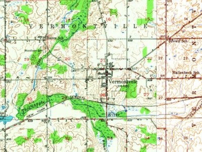
Every edition of the U.S. Geological Survey’s map of Vermontville. Tap a year, or press play to watch the town change.
1950Nashville sheet · 1:62,500
U.S. Geological Survey historical topographic maps (public domain), via Esri’s collection of the scans. The red ring marks the center of Vermontville.
Every building
Vermontville, building by building, 1906–1916
Fire insurance maps drew every building, what it was made of and what it was used for, so insurers could price the risk of fire. Pick a year, then a sheet.
1906Sheet 1 of 1
Edition
Sheets
BrickWoodStone
Sanborn Map Company, via the Library of Congress. Editions published in 1930 or earlier, which are in the public domain.
On the National Register
3 historic places in Vermontville
The country’s official list of buildings and places worth saving.
places listed
3
National Historic Landmarks
0
none yet
historic buildings protected
3
each building in a district counts
National Park Service, National Register of Historic Places. Photos from Wikimedia Commons, credited on each place’s page.
People over time
Vermontville, census by census
Between 544 and 857 people in every census since 1870.
16 censuses, 1870–2020.
U.S. Census Bureau decennial counts, from the census table on Vermontville’s Wikipedia page.
Famous people
3 famous people were born in Vermontville
Writers, athletes, leaders and more, ranked by how widely they’re known.
Founding dates: Wikidata, Wikipedia, the U.S. post office records of Blevins & Helbock (CC0) and the Census. Homes by year built: Census ACS 2020–24. National Register of Historic Places: National Park Service (list of May 22, 2026). Old photos, postcards and papers: Wikimedia Commons, the Library of Congress and other public archives, credited on each item’s page. Maps: U.S. Geological Survey historical topographic maps (via Esri) and Sanborn fire-insurance maps (Library of Congress). History text and census tables: Wikipedia (CC BY-SA 4.0). Places that used to be: USGS Geographic Names Information System (2021). How TownRatings grades history →
From Wikimedia Commons (6), Wikipedia, Wikidata and Wikipedia for famous people, U.S. Geological Survey historical maps, U.S. Census counts (via Wikipedia), Sanborn fire insurance maps (Library of Congress) and old county and town histories (Internet Archive). Archive images are copied here with their credits and licenses, shown on each photo’s page. Refreshed monthly.




 2014
 2014
 2014
 2014
 2014
 2005


