1 of Portland Township’s places is on the National Register
Its Register listing is the Portland First Congregational Church. Most of Portland Township was built recently: 5% of its homes predate 1940 and the median home dates from 1996. Below: 2 old photos and papers, maps from 1945 on, and the census since 1860.
According to government records, the first land that was owned in what is now known as Portland was owned by Elisha Newman in 1833. Ionia County histories say that Philo Bogue built a trading post on the Grand River later that year, the Bogue Flats Recreation Area now being named for him. The first post office arrived in 1837. Portland has been home to several Native American tribes, and was the dwelling-place of John Okemos in the 1850s.
Nothing in the archives for these yearsWeddings on Main Street, storms, parades, school pictures, the old store. If it’s in your family album, it belongs here.
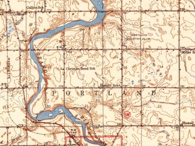
Every edition of the U.S. Geological Survey’s map of Portland Township. Tap a year, or press play to watch the town change.
1945Portland sheet · 1:62,500
U.S. Geological Survey historical topographic maps (public domain), via Esri’s collection of the scans. The red ring marks the center of Portland Township.
Then & now
Stand where they stood
No then-and-now pairs yet. Take a photo from the same spot as an old one and they appear here side by side.
Retake this viewPortland, Mich, 1907
Find the spot, match the angle, and add your photo. It becomes the first then-and-now pair on Portland Township’s page.
Founding dates: Wikidata, Wikipedia, the U.S. post office records of Blevins & Helbock (CC0) and the Census. Homes by year built: Census ACS 2020–24. National Register of Historic Places: National Park Service (list of May 22, 2026). Old photos, postcards and papers: Wikimedia Commons, the Library of Congress and other public archives, credited on each item’s page. Maps: U.S. Geological Survey historical topographic maps (via Esri) and Sanborn fire-insurance maps (Library of Congress). History text and census tables: Wikipedia (CC BY-SA 4.0). Places that used to be: USGS Geographic Names Information System (2021). How TownRatings grades history →
From Wikimedia Commons (6), the National Register of Historic Places (1), Wikipedia, U.S. Geological Survey historical maps, U.S. Census counts (via Wikipedia), the US Post Offices dataset (Blevins & Helbock) and the USGS Geographic Names Information System. Archive images are copied here with their credits and licenses, shown on each photo’s page. Refreshed monthly.


 1907
 2017
 2014
 2014
 2005


