Fire insurance maps drew every building, what it was made of and what it was used for, so insurers could price the risk of fire. Pick a year, then a sheet.
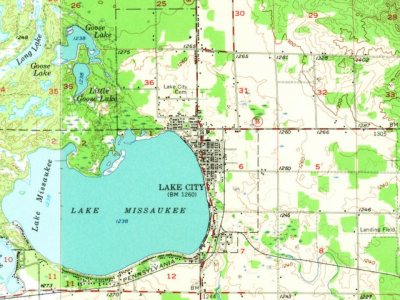
The community's first settler, Daniel Reader, built his cabin on Muskrat Lake, now Lake Missaukee, in 1868. On January 22, 1872, Reeder was the name of post office open and the last name of its first postmaster, Daniel. The county selected Reeder by a one-vote margin as the county seat in 1873. The community became a station of the Grand Rapids and Indiana Railroad. The community was renamed on January 25, 1877, to Lake City. Lake City was incorporated as a village and platted in 1889. The village became a city in 1932.
Much of Missaukee County grew in the early 20th century because of the region's timber industry. The community continues to thrive because of local lumber mills.
Nothing in the archives for these yearsWeddings on Main Street, storms, parades, school pictures, the old store. If it’s in your family album, it belongs here.
Nothing in the archives for these yearsWeddings on Main Street, storms, parades, school pictures, the old store. If it’s in your family album, it belongs here.
Founding dates: Wikidata, Wikipedia, the U.S. post office records of Blevins & Helbock (CC0) and the Census. Homes by year built: Census ACS 2020–24. National Register of Historic Places: National Park Service (list of May 22, 2026). Old photos, postcards and papers: Wikimedia Commons, the Library of Congress and other public archives, credited on each item’s page. Maps: U.S. Geological Survey historical topographic maps (via Esri) and Sanborn fire-insurance maps (Library of Congress). History text and census tables: Wikipedia (CC BY-SA 4.0). Places that used to be: USGS Geographic Names Information System (2021). How TownRatings grades history →
From Wikimedia Commons (9), the Library of Congress (7), Wikipedia, Wikidata and Wikipedia for famous people, U.S. Geological Survey historical maps, U.S. Census counts (via Wikipedia), the US Post Offices dataset (Blevins & Helbock), the USGS Geographic Names Information System and Sanborn fire insurance maps (Library of Congress). Archive images are copied here with their credits and licenses, shown on each photo’s page. Refreshed monthly.



 1880
 1890
 1890
 1900
 2024
 2021
 2021
 2020
 2019
 2017
 2014

