Flint dates to 1818, and 26% of its homes were built before 1940
More historic than 95% of U.S. towns · #30 of 701 in Michigan. What drives it
27 places in town are on the National Register, among them the Durant-Dort Carriage Company Office, a National Historic Landmark, and three historic districts with 977 buildings between them. Below: 3 old photos and papers, maps from 1886 on, and the census since 1850.
Founding year: Wikidata. First post office: 1835.The full story ↓
History grade
What drives Flint’s History grade
On its age, its old homes and the National Register, Flint is more historic than 95% of U.S. towns, #30 of 701 in Michigan. All 3 inputs are above most U.S. towns; its National Register listings ranks highest and its age lowest.
A+
HistoryA character grade: shown, never part of Flint’s overall grade.
Few Michigan towns list much on the Register (a typical Michigan town has 0.0 per 10,000 residents, the U.S. 2.4), so Flint’s 125 sits above most of its state (95% of Michigan towns have fewer) while its 1,006 historic buildings outnumber those of 99% of U.S. towns.
How sure. Graded on any two of the three inputs instead, the letter would range from A− to A+. The pre-1940 share (±1.3 points) is firm at this size. Two sources give 1818.
Founding year: Wikidata (other dates in Quick answers). Homes: Census ACS 2020–24. National Register: National Park Service, May 2026 list; each listing counted once (boundary changes and added documentation belong to their listing), and a historic district counts its contributing buildings. How TownRatings grades history →
What stands out about Flint’s past
Read from the archive, the National Register and the record. The page puts what stands out first.
National Park Service, National Register of Historic Places. Photos from Wikimedia Commons, credited on each place’s page.
Places that used to be
Lost post offices, old corners, places now gone and burying grounds
Flint’s post office has been open since 1836. Two other post offices opened and closed inside today’s town.
Flint River
1835–1836
Flint
1836–today
Lewis
1899–1902
18301930today
Hamlets and corners on the map
American Mobile Home ParkCarriage Hills Mobile Home ParkCarriage Manor Mobile Home ParkElms Mobile Home ParkHoliday Village Mobile Home ParkHolt's Mobile Home CourtKirkwood Community Mobile Home ParkLakeside Mobile CourtMcGrew JunctionRichfield Mobile Home ParkRoyal Mobile Home ParkShady Acres Mobile Home ParkTwilight Mobile Home Park
Gone or out of use
Buick Motor Company Historical Markerpark
9cemeteries and burying grounds inside Flint
AssyrianAventineAvondaleGlenwoodGracelawnMachpelahOld Calvary CatholicSaint Michael's Byzantine CatholicSaint Nicholas Orthodox Church
US Post Offices dataset (Blevins & Helbock, CC0). Places and cemeteries from the USGS Geographic Names Information System (2021).
The region was home to several Ojibwe tribes at the start of the 19th century, with a particularly significant community established near present-day Montrose. The Flint River had several convenient fords which became points of contention among rival tribes, as attested by the presence of nearby arrowheads and burial mounds. Some of the city currently resides atop ancient Ojibwe burial grounds.
Passages that mention Flint, cut from the printed page as they were published.
History of Genesee county, Michigan. With illustrations and biographical sketches of its prominent men and pioneers1879Read the page →
Read the text
amble and resolutions, of date Oct. 12, 1855, resolved as follows : " \\lnn-rnn, ApplJcalion has Vjoon made, according to law, to divide the township of Flint into two townships; and whereas, the township of Flint includes two surveyed townships, excejit that part included in the city of Flint.
Text read by machine from the scan; it may contain errors.
History of Genesee county Michigan1916 · page 42Read the page →
Read the text
aiiciit for tlic L'niun Trust and Sa\ini;"s liank of l-"linl and still occupies that pfjsition, although he latel}- has been called on to perforin tlie duties of chief e\ecnti\-e head of the city of Flint, a position which he now occupies. On April 3, 1910, Jiarl V. lohnson was elected mayor of Flint and it is a suflicient attestation of his personal popularity in that city to note that he was elected by the greatest majority e\er given .1 candidate for the office '.f mayor in the city of Flint.
Text read by machine from the scan; it may contain errors.
History of Genesee county, Michigan. With illustrations and biographical sketches of its prominent men and pioneers1879Read the page →
Read the text
The township of Flint w.xs ori<;inally organized in 1836, by act of Legislature, from " all that part of the county embraced in surveyed townships 7, 8, and 9 north, in ranges 5, 6, and 7 east," and the first township-meeting was lield at the house of Wait Beach, at the Flint llivcr settlement. In the year 1855 the city became a separate corporation, and the territory of the township was divided, — the west half retaining the name of Flint, and the east
Text read by machine from the scan; it may contain errors.
during which time he was variousl}' engaged, working in saw-mills, shinglemills and stores, presen.tly becoming the manager of the general store of Fargo, Brackett & Company, his former employers in the saw-mill. On Christmas Eve, 1887, he arrived in Flint, with a view to making his home there, and has resided there practically all 'the time since. For eighteen months after his arri\al at Flint he worked in the Flint Wagon Works and then engaged in the gr()cer\- business at Bancroft, in the neighboring county of Shiawassee, in partnership with Hiram Beidelman. Ten months later he
Text read by machine from the scan; it may contain errors.
Scans and text from the Internet Archive. Books published in 1930 or earlier, which are in the public domain.
Timeline
Flint, 1818 to 1960
Woven from the archive, old maps, post office records, the National Register and the people born here.
Nothing in the archives for these yearsWeddings on Main Street, storms, parades, school pictures, the old store. If it’s in your family album, it belongs here.
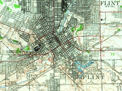
Every edition of the U.S. Geological Survey’s map of Flint. Tap a year, or press play to watch the town change.
1920Flint sheet · 1:62,500
U.S. Geological Survey historical topographic maps (public domain), via Esri’s collection of the scans. The red ring marks the center of Flint.
Every building
Flint, building by building, 1886–1914
Fire insurance maps drew every building, what it was made of and what it was used for, so insurers could price the risk of fire. Pick a year, then a sheet.
In 1818, according to Wikidata. Flint’s post office opened in 1835, and the census of 1850 counted 1,670 people here.
How does Flint rank for history?
Flint is more historic than 95% of U.S. towns, #30 of 701 in Michigan. The History grade combines the town’s founding era, the share of homes built before 1940 and its National Register listings. It’s a character grade, so it isn’t part of the overall grade. How it works.
What is on the National Register in Flint?
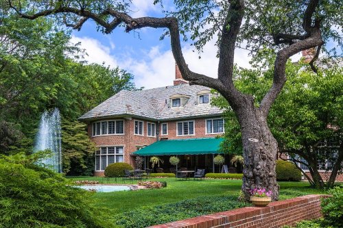
27 listings: 22 buildings, among them the Durant-Dort Carriage Company Office (a National Historic Landmark since 1978) and the Superintendent's Cottage (listed 1975, the first), 3 historic districts, the Civic Park Historic District, the Glenwood Cemetery and the City of Flint Municipal Center, with 977 contributing buildings, and 2 structures. 1,006 historic buildings in all.
How old are the homes in Flint?
26% of Flint’s homes were built before 1940 (Census estimate, ±1.3 points), against a typical 12% for a Michigan town; the median home was built in 1954.
Founding dates: Wikidata, Wikipedia, the U.S. post office records of Blevins & Helbock (CC0) and the Census. Homes by year built: Census ACS 2020–24. National Register of Historic Places: National Park Service (list of May 22, 2026). Old photos, postcards and papers: Wikimedia Commons, the Library of Congress and other public archives, credited on each item’s page. Maps: U.S. Geological Survey historical topographic maps (via Esri) and Sanborn fire-insurance maps (Library of Congress). History text and census tables: Wikipedia (CC BY-SA 4.0). Places that used to be: USGS Geographic Names Information System (2021).
From the Library of Congress (3), Wikidata (15), the National Register of Historic Places (27), Wikipedia, Wikidata and Wikipedia for famous people, U.S. Geological Survey historical maps, U.S. Census counts (via Wikipedia), the US Post Offices dataset (Blevins & Helbock), the USGS Geographic Names Information System, Sanborn fire insurance maps (Library of Congress) and old county and town histories (Internet Archive). Archive images are copied here with their credits and licenses, shown on each photo’s page. Refreshed monthly.


 ★ Landmark






 1915


