


The story
Read it all →How Brighton Township came to be
From Wikipedia’s history of Brighton Township.
Brighton was established in 1832. It was incorporated as a village in 1867 and as a city in 1928.
Text from Wikipedia, licensed CC BY-SA 4.0.
Each edition grades its towns against each other only.
 Photo: WeaponizingArchitecture · CC BY-SA 4.0
More historic than 52% of U.S. towns · #337 of 701 in Michigan. What drives it
Most of Brighton Township was built recently: 2% of its homes predate 1940 and the median home dates from 1986. Its Register listing is the Timothy and Lucretia Jones Warner Homestead. Below: 2 old photos and papers, maps from 1909 on, and the census since 1860.
Brighton Township dates its founding to 1832 (Wikidata and Wikipedia’s history agree). The census first counted it in 1860.
More historic than 52% of U.S. towns, on its age, its old homes and the National Register.
On its age, its old homes and the National Register, Brighton Township is more historic than 52% of U.S. towns, #337 of 701 in Michigan. Its age holds the grade up; its share of homes from before 1940 pulls it down.
Few Michigan towns list much on the Register (a typical Michigan town has 0.0 per 10,000 residents, the U.S. 2.4), so Brighton Township’s 0.5 sits near the middle of its state (64% of Michigan towns have fewer) while its 1 listings outnumber those of 51% of U.S. towns.
Founding year: Wikidata (other dates in Quick answers). Homes: Census ACS 2020–24. National Register: National Park Service, May 2026 list; each listing counted once (boundary changes and added documentation belong to their listing), and a historic district counts its contributing buildings. How TownRatings grades history →
Read from the archive, the National Register and the record. The page puts what stands out first.
The first neighbors to add old photos shape how Brighton Township’s history is told.
Every edition of the U.S. Geological Survey’s map of Brighton Township. Tap a year, or press play to watch the town change.

U.S. Geological Survey historical topographic maps (public domain), via Esri’s collection of the scans. The red ring marks the center of Brighton Township.
Woven from the archive, old maps, post office records, the National Register and the people born here.
 On the mapFirst mapped by the U.S. Geological Survey
From Wikipedia’s history of Brighton Township.
Brighton was established in 1832. It was incorporated as a village in 1867 and as a city in 1928.
Text from Wikipedia, licensed CC BY-SA 4.0.
 2012Statues at Osprey Management Company, 7600 Grand Rive…
 2012Residential Christmas Decorations, W. Main St
 2012Quartet of Deer in Wooded Area, Hammel Road
 2012Millpond
 2012George and Lenore Romney Grave, Fairview Cemetery
 2012Firehouse Subs Franchise
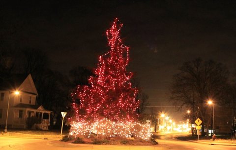 2012Christmas Tree on Main Street
 2012Christmas Decorations at Stillwater Grill, 503 w. Gra…
 2012Bread of Life Tabernacle
 2012Bingham House Historic Site, (1842), 13270 Silver Lak…
 2012Beautiful Sunset Near
 2012Beautiful Sunset Near Brighton - panoramio (2)
 2012Beautiful Sunset Near Brighton - panoramio (1)
 2011Westside Stone, 11815 Grand River Road, Green Oak Tow…
 2011Spanish-American War Regiments historical marker
 2011Fonda Island ^ Briggs Lake Joint Water Authority Wate…
 2011Brighton Village Cemetery historic site
 2011Brighton District No. 8 School
 2011Appleton House historic site
 2010Westphal House
 2010Western House
 2010Old Town Hall Historic Marker
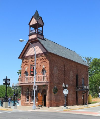 2010Old Town Hall
 2010Downtown Brighton Michigan Main Street
 2010Downtown Brighton Michigan Grand River Avenue
 2010Chainsaw carving of owls Brighton Recreation Area Mic…
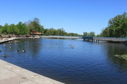 2010Brighton Michigan Millpond Park
 2010Bishop Lake Campground Brighton Recreation Area Michi…
 2010Bingham House
 2008BrightonMall
No then-and-now pairs yet. Take a photo from the same spot as an old one and they appear here side by side.

Find the spot, match the angle, and add your photo. It becomes the first then-and-now pair on Brighton Township’s page.
Retake this view · +15The country’s official list of buildings and places worth saving.
National Park Service, National Register of Historic Places. Photos from Wikimedia Commons, credited on each place’s page.
Grew from 252 people in 1860 to 7,446 in 2020, more than tenfold.
17 censuses, 1860–2020.
U.S. Census Bureau decennial counts, from the census table on Brighton Township’s Wikipedia page.
Another post office, Pleasant Valley, opened and closed inside today’s town.
US Post Offices dataset (Blevins & Helbock, CC0). Places and cemeteries from the USGS Geographic Names Information System (2021).
Each neighbor’s History grade, on the same three inputs.
In 1832, according to Wikidata and Wikipedia’s history of the town. Brighton Township’s post office opened in 1837, and the census of 1860 counted 252 people here.
Brighton Township is more historic than 52% of U.S. towns, #337 of 701 in Michigan. The History grade combines the town’s founding era, the share of homes built before 1940 and its National Register listings. It’s a character grade, so it isn’t part of the overall grade. How it works.
One place: the Timothy and Lucretia Jones Warner Homestead (listed 2011).
2% of Brighton Township’s homes were built before 1940 (Census estimate, ±1.0 points), against a typical 12% for a Michigan town; the median home was built in 1986.
What the archives can’t tell you, neighbors can.
Founding dates: Wikidata, Wikipedia, the U.S. post office records of Blevins & Helbock (CC0) and the Census. Homes by year built: Census ACS 2020–24. National Register of Historic Places: National Park Service (list of May 22, 2026). Old photos, postcards and papers: Wikimedia Commons, the Library of Congress and other public archives, credited on each item’s page. Maps: U.S. Geological Survey historical topographic maps (via Esri) and Sanborn fire-insurance maps (Library of Congress). History text and census tables: Wikipedia (CC BY-SA 4.0). Places that used to be: USGS Geographic Names Information System (2021).
From Wikimedia Commons (31), the Library of Congress (1), Wikidata (1), the National Register of Historic Places (1), Wikipedia, U.S. Geological Survey historical maps, U.S. Census counts (via Wikipedia), the US Post Offices dataset (Blevins & Helbock) and the USGS Geographic Names Information System. Archive images are copied here with their credits and licenses, shown on each photo’s page. Refreshed monthly.
 Date?
 Date?
