Founding year: Wikidata. First post office: 1883.The full story ↓
History grade
What drives Oakland’s History grade
On its age, its old homes and the National Register, Oakland is more historic than 51% of U.S. towns, #126 of 143 in Maine. Its share of homes from before 1940 holds the grade up; its age pulls it down.
B−
HistoryA character grade: shown, never part of Oakland’s overall grade.
Maine towns list more on the Register than most of the country (a typical Maine town has 15.9 per 10,000 residents, the U.S. 2.4), so Oakland’s 7.9 sits near the middle of its state (36% of Maine towns have fewer) while its 5 historic buildings outnumber those of 70% of U.S. towns.
How sure. Graded on any two of the three inputs instead, the letter would range from C+ to B. The pre-1940 share is a Census survey estimate (±6.2 points). Two sources give 1873.
Founding year: Wikidata (other dates in Quick answers). Homes: Census ACS 2020–24. National Register: National Park Service, May 2026 list; each listing counted once (boundary changes and added documentation belong to their listing), and a historic district counts its contributing buildings. How TownRatings grades history →
What stands out about Oakland’s past
Read from the archive, the National Register and the record. The page puts what stands out first.
Nothing in the archives for these yearsWeddings on Main Street, storms, parades, school pictures, the old store. If it’s in your family album, it belongs here.
The area that is now Oakland was first settled in about 1780 by colonists of English descent from Massachusetts and New Hampshire. At that time, the region was known as Taconnet after Indian Chief Taconnet, an Abenaki nation sachem. Farmers found the area's fertile soil good for cultivation, grazing and dairy farming, while the water power provided by the Messalonskee Stream was useful for manufacturers. The area was incorporated by the Massachusetts General Court in 1771 as part of Winslow. In 1802, the area of Winslow west of the Kennebec River was incorporated as Waterville.
Passages that mention Oakland, cut from the printed page as they were published.
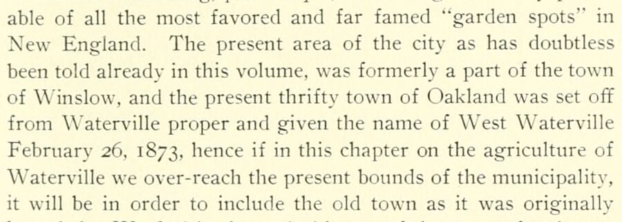
The centennial history of Waterville, Kennebec County, Maine, including the oration, the historical address and the poem presented at the celebration of the centennial anniversary of the incorporation of the town, June 23d, 1902 ..1902 · page 331Read the page →
Read the text
able of all the most favored and far famed "garden spots" in New England. The present area of the city as has doubtless been told already in this volume, was formerly a part of the town of Winslow, and the present thrifty town of Oakland was set off from Waterville proper and given the name of West Waterville February 26, 1873, hence if in this chapter on the agriculture of Waterville we over-reach the present bounds of the municipality, it will be in order to include the old town as it was originally
Text read by machine from the scan; it may contain errors.
Illustrated history of Kennebec County, Maine1892 · page 1064Read the page →
Read the text
produced a feeling of remonstrance in the western section, until West Waterville was incorporated as a town in 1873. In 1883, the name both of the town and of the post office was changed from West Waterville to Oakland. This portion of old Winslow was noted from the first for the abundance and variety of its forest productions, for the richness of its soil, the absence of troublesome quantities of stone, and for the favorable lay of the land for farming purposes. But the chiefest gift in
Text read by machine from the scan; it may contain errors.
The centennial history of Waterville, Kennebec County, Maine, including the oration, the historical address and the poem presented at the celebration of the centennial anniversary of the incorporation of the town, June 23d, 1902 ..1902 · page 339Read the page →
Read the text
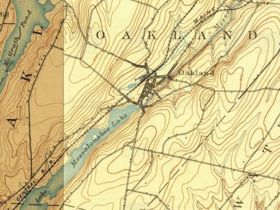
is found the Messalonskee, the outlet of the lake of the same tiame into which are discharged the waters of East, North, AIcGrath, Ellis, Great, and Long ponds or lakes lying partly in Smithfield, Belgrade, and Oakland. This stream flows northerly about four miles with a fall in that distance of about 150 feet of which about too feet are in the village of Oakland and within less than a mile from the outlet. Turning to the east and then to the south it empties into the Kennebec about two miles below
Text read by machine from the scan; it may contain errors.
Illustrated history of Kennebec County, Maine1892 · page 1071Read the page →
Read the text
Oakland Savings Bank was incorporated in 1869 as the West Waterville Savings Bank, and was changed to the present title in 1883. The first meeting for organization was held at the office of G. T.
Text read by machine from the scan; it may contain errors.
Scans and text from the Internet Archive. Books published in 1930 or earlier, which are in the public domain.
Timeline
Oakland, 1808 to 1930
Woven from the archive, old maps, post office records, the National Register and the people born here.
Fire insurance maps drew every building, what it was made of and what it was used for, so insurers could price the risk of fire. Pick a year, then a sheet.
In 1873, according to Wikidata. Oakland’s post office opened in 1883, and the census of 1880 counted 1,647 people here.
How does Oakland rank for history?
Oakland is more historic than 51% of U.S. towns, #126 of 143 in Maine. The History grade combines the town’s founding era, the share of homes built before 1940 and its National Register listings. It’s a character grade, so it isn’t part of the overall grade. How it works.
What is on the National Register in Oakland?
4 listings: 4 buildings, among them the Pressey House (listed 1977, the first). 5 historic buildings in all.
How old are the homes in Oakland?
16% of Oakland’s homes were built before 1940 (Census estimate, ±6.2 points), against a typical 19% for a Maine town; the median home was built in 1982.
Founding dates: Wikidata, Wikipedia, the U.S. post office records of Blevins & Helbock (CC0) and the Census. Homes by year built: Census ACS 2020–24. National Register of Historic Places: National Park Service (list of May 22, 2026). Old photos, postcards and papers: Wikimedia Commons, the Library of Congress and other public archives, credited on each item’s page. Maps: U.S. Geological Survey historical topographic maps (via Esri) and Sanborn fire-insurance maps (Library of Congress). History text and census tables: Wikipedia (CC BY-SA 4.0). Places that used to be: USGS Geographic Names Information System (2021).
From Wikimedia Commons (23), Wikidata (2), the National Register of Historic Places (4), Wikipedia, Wikidata and Wikipedia for famous people, U.S. Geological Survey historical maps, U.S. Census counts (via Wikipedia), the US Post Offices dataset (Blevins & Helbock), the USGS Geographic Names Information System, Sanborn fire insurance maps (Library of Congress) and old county and town histories (Internet Archive). Archive images are copied here with their credits and licenses, shown on each photo’s page. Refreshed monthly.



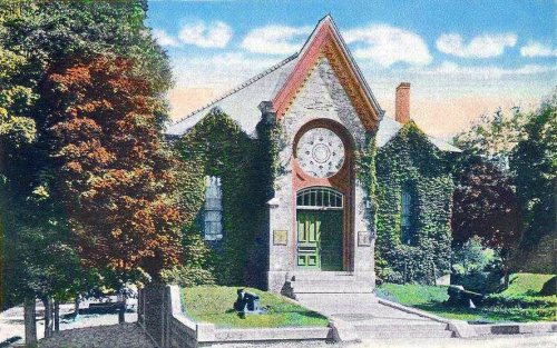
 c. 1906
 1908
 c. 1920
 c. 1920
 c. 1930
 c. 1930
 c. 1930
 c. 1930
 c. 1930
 c. 1930
 c. 1930
 c. 1930
 c. 1930
 Date?
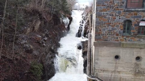 2022
 2022
 2022
 2022
 2022
 2022
 2012
 2011
 2004