On its age, its old homes and the National Register, North Berwick is more historic than 83% of U.S. towns, #66 of 143 in Maine. All 3 inputs are above most U.S. towns; its share of homes from before 1940 ranks highest and its National Register listings lowest.
A−
HistoryA character grade: shown, never part of North Berwick’s overall grade.
Maine towns list more on the Register than most of the country (a typical Maine town has 15.9 per 10,000 residents, the U.S. 2.4), so North Berwick’s 13.6 sits near the middle of its state (50% of Maine towns have fewer) while its 7 historic buildings outnumber those of 73% of U.S. towns.
NoteThe founding year comes from Wikidata alone; no second source gives 1831.
How sure. Graded on any two of the three inputs instead, the letter would still be A−. The pre-1940 share is a Census survey estimate (±8.2 points).
Founding year: Wikidata (other dates in Quick answers). Homes: Census ACS 2020–24. National Register: National Park Service, May 2026 list; each listing counted once (boundary changes and added documentation belong to their listing), and a historic district counts its contributing buildings. How TownRatings grades history →
What stands out about North Berwick’s past
Read from the archive, the National Register and the record. The page puts what stands out first.
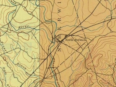
Every edition of the U.S. Geological Survey’s map of North Berwick. Tap a year, or press play to watch the town change.
1891Kennebunk sheet · 1:62,500
U.S. Geological Survey historical topographic maps (public domain), via Esri’s collection of the scans. The red ring marks the center of North Berwick.
On the National Register
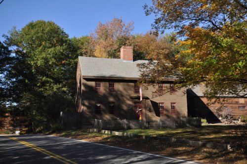
6 historic places in North Berwick
The country’s official list of buildings and places worth saving.
Originally a part of Kittery called Kittery Commons, the area was first settled in 1693 by John Morrell, a Quaker who built a log cabin on Wells Street. It was set off from Kittery in 1713 as part of Berwick, named for Berwick-upon-Tweed on the Anglo-Scottish border. Doughty Falls in the Great Works River provided water power for a sawmill, gristmill and carding mill. After the Revolutionary War, the small mill town grew rapidly. It was set off and incorporated as North Berwick on March 22, 1831. The town was named after Berwick, England.
Passages that mention North Berwick, cut from the printed page as they were published.
History of York County, Maine. With illustrations and biographical sketches of its prominent men and pioneers1880 · page 299Read the page →
Read the text
The old "North Parish Congregational Church" was organized Jan. 15, 1749, when Berwick included what is now Berwick, South and North Berwick, and the First (or South) Parish included the whole territory except the parsonage grant " to the Baptist Society in Berwick," located at " Great Hill." The South Parish meeting-house was located at what was called " Old Fields," near the " Lower Landing" below " Quampheagan Landing." The parish was
Text read by machine from the scan; it may contain errors.
History of York County, Maine. With illustrations and biographical sketches of its prominent men and pioneers1880Read the page →
Read the text
The town of North Berwick is the northeastern half of what was left of Berwick after the incorporation of South Berwick, in 1814.
Text read by machine from the scan; it may contain errors.
A centennial history of Alfred, York County, Maine1872 · page 23Read the page →
Read the text
gether for social worship. About 1780 a church was formed consisting of from twelve to twenty members under the charge of Rev. Mr. Little, of Kennebunk, andMerriam, of North Berwick, who administered the ordinances of baptism and the sacrament. In 1782, this society was formed into what was callel the north parish of Sanford, where itinerant preacliers officiated occasionally. In 1786, Rev. Moses ■tSweat settled in Sanford, and frequently preached in the
Text read by machine from the scan; it may contain errors.
Scans and text from the Internet Archive. Books published in 1930 or earlier, which are in the public domain.
By decade
North Berwick, decade by decade
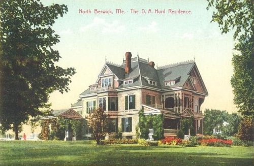
3 decades in the archive, from the 1870s to the 1910s. Scroll each row; tap a photo for its story.
Nothing in the archives for these yearsWeddings on Main Street, storms, parades, school pictures, the old store. If it’s in your family album, it belongs here.
Fire insurance maps drew every building, what it was made of and what it was used for, so insurers could price the risk of fire. Pick a year, then a sheet.
In 1831, according to Wikidata. the census of 1840 counted 1,461 people here.
How does North Berwick rank for history?
North Berwick is more historic than 83% of U.S. towns, #66 of 143 in Maine. The History grade combines the town’s founding era, the share of homes built before 1940 and its National Register listings. It’s a character grade, so it isn’t part of the overall grade. How it works.
What is on the National Register in North Berwick?
6 listings: 6 buildings, among them the Morrell House (listed 1976, the first). 7 historic buildings in all.
How old are the homes in North Berwick?
24% of North Berwick’s homes were built before 1940 (Census estimate, ±8.2 points), against a typical 19% for a Maine town; the median home was built in 1983.
Founding dates: Wikidata, Wikipedia, the U.S. post office records of Blevins & Helbock (CC0) and the Census. Homes by year built: Census ACS 2020–24. National Register of Historic Places: National Park Service (list of May 22, 2026). Old photos, postcards and papers: Wikimedia Commons, the Library of Congress and other public archives, credited on each item’s page. Maps: U.S. Geological Survey historical topographic maps (via Esri) and Sanborn fire-insurance maps (Library of Congress). History text and census tables: Wikipedia (CC BY-SA 4.0). Places that used to be: USGS Geographic Names Information System (2021).
From Wikimedia Commons (18), the National Register of Historic Places (6), Wikipedia, Wikidata and Wikipedia for famous people, U.S. Geological Survey historical maps, U.S. Census counts (via Wikipedia), the USGS Geographic Names Information System, Sanborn fire insurance maps (Library of Congress) and old county and town histories (Internet Archive). Archive images are copied here with their credits and licenses, shown on each photo’s page. Refreshed monthly.








 1877
 1910
 1910
 1910
 c. 1910
 2018
 2018
 2015
 2015
 2015
 2015
 2015
 2015
 2011
 2001

