Benton’s post office opened in 1852, and 19% of its homes were built before 1940
More historic than 62% of U.S. towns · #110 of 143 in Maine. What drives it
2 places in town are on the National Register, among them a historic district with 5 buildings. Below: 1 old photo or paper, maps from 1892 on, and the census since 1850.
The Benton post office opened in 1852, the earliest record of the town by name. Three smaller post offices, East Benton (1858), Benton Falls (1878) and Benton Station (1888), opened inside today’s town and later closed.
First census: 1,189 in 18502020 census: 2,715174 years
How historic is Benton?
B
More historic than 62% of U.S. towns, on its age, its old homes and the National Register.
Founding year: the first Benton post office (Blevins & Helbock, CC0).
History grade
What drives Benton’s History grade
On its age, its old homes and the National Register, Benton is more historic than 62% of U.S. towns, #110 of 143 in Maine. Its share of homes from before 1940 holds the grade up; its age pulls it down.
B
HistoryA character grade: shown, never part of Benton’s overall grade.
Maine towns list more on the Register than most of the country (a typical Maine town has 15.9 per 10,000 residents, the U.S. 2.4), so Benton’s 21.7 sits near the middle of its state (61% of Maine towns have fewer) while its 6 historic buildings outnumber those of 72% of U.S. towns.
How sure. Graded on any two of the three inputs instead, the letter would range from B− to B+. The pre-1940 share is a Census survey estimate (±6.3 points). The founding year is the first post office, not a stated founding date.
Founding year: the first post office (other dates in Quick answers). Homes: Census ACS 2020–24. National Register: National Park Service, May 2026 list; each listing counted once (boundary changes and added documentation belong to their listing), and a historic district counts its contributing buildings. How TownRatings grades history →
What stands out about Benton’s past
Read from the archive, the National Register and the record. The page puts what stands out first.
US Post Offices dataset (Blevins & Helbock, CC0). Places and cemeteries from the USGS Geographic Names Information System (2021).
On the map
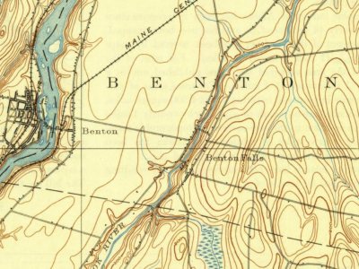
Benton on the map, 1892 to 1982
Every edition of the U.S. Geological Survey’s map of Benton. Tap a year, or press play to watch the town change.
1892Waterville sheet · 1:62,500
U.S. Geological Survey historical topographic maps (public domain), via Esri’s collection of the scans. The red ring marks the center of Benton.
The story so far
Benton, in brief
Wikipedia doesn’t have a history of Benton yet. The photos, dates and memories neighbors add here are how it gets written.
Benton is a town in Kennebec County, Maine, United States. It was formed in 1842, as a subdivision of the town of Clinton. The population was 2,715 at the 2020 census. The town was named for Missouri Senator Thomas Hart Benton.
Its first post office opened in 1852. Its population held steady between the last two censuses: 2,732 in 2010, 2,715 in 2020.
Intro from Wikipedia. Population: U.S. Census Bureau.
From the old history books
What they wrote about Benton in 1892
Passages that mention Benton, cut from the printed page as they were published.
Illustrated history of Kennebec County, Maine1892 · page 1218Read the page →
Read the text
THE first entry in the records of the town now known as Benton is that of " an act of the State of Maine entitled ' An act to divide the town of Clinton and to incorporate the town of Sebasticook.' " This act was approved March 16, 1842. Eight years later, on March 4th, the town voted " that the selectmen report a new name for the town at our next meeting." The selectmen reported in favor of the name of Benton, in honor of Thomas H. Benton, a prominent democrat, and author of Thirty Years in the United States Senate. This name
Text read by machine from the scan; it may contain errors.
Illustrated history of Kennebec County, Maine1892 · page 1243Read the page →
Read the text
the first entry is the copy of "An Act to Incorporate the Plantation of Hancock in the County of Lincoln into a Town by the name of Clinton," February 27, 1795. At this time the most thickly populated portion of Clinton lay in what is now the town of Benton, and it was here, according to the records, that the first town meeting was held, April 20, 1795, at the house of Captain Jonathan Philbrook. At this meeting Ezekiel Brown, jun., was chosen moderator and clerk; Ebenezer Heald, treasurer, and Captain Andrew Richardson, John Burrill
Text read by machine from the scan; it may contain errors.
Scans and text from the Internet Archive. Books published in 1930 or earlier, which are in the public domain.
Timeline
Benton, 1843 to 1957
Woven from the archive, old maps, post office records, the National Register and the people born here.
Nothing in the archives for these yearsWeddings on Main Street, storms, parades, school pictures, the old store. If it’s in your family album, it belongs here.
The Benton post office opened in 1852, the earliest record of the town by name (U.S. post office records).
How does Benton rank for history?
Benton is more historic than 62% of U.S. towns, #110 of 143 in Maine. The History grade combines the town’s founding era, the share of homes built before 1940 and its National Register listings. It’s a character grade, so it isn’t part of the overall grade. How it works.
What is on the National Register in Benton?
Two places: the Benton Grange #458 (listed 2004) and the Colcord Farmstead (2005).
How old are the homes in Benton?
19% of Benton’s homes were built before 1940 (Census estimate, ±6.3 points), against a typical 19% for a Maine town; the median home was built in 1980.
Founding dates: Wikidata, Wikipedia, the U.S. post office records of Blevins & Helbock (CC0) and the Census. Homes by year built: Census ACS 2020–24. National Register of Historic Places: National Park Service (list of May 22, 2026). Old photos, postcards and papers: Wikimedia Commons, the Library of Congress and other public archives, credited on each item’s page. Maps: U.S. Geological Survey historical topographic maps (via Esri) and Sanborn fire-insurance maps (Library of Congress). History text and census tables: Wikipedia (CC BY-SA 4.0). Places that used to be: USGS Geographic Names Information System (2021).
From Wikimedia Commons (5), the National Register of Historic Places (2), Wikidata and Wikipedia for famous people, U.S. Geological Survey historical maps, U.S. Census counts (via Wikipedia), the US Post Offices dataset (Blevins & Helbock), the USGS Geographic Names Information System and old county and town histories (Internet Archive). Archive images are copied here with their credits and licenses, shown on each photo’s page. Refreshed monthly.


 2022
 2011
 2009
 2009
