32% of Williamsport’s homes were built before 1940
Among the most historic 1% of U.S. towns. What drives it
5 places in town are on the National Register, among them a historic district with 416 buildings. Below: 30 old photos and papers, maps from 1918 on, and the census since 1850.
On its age, its old homes and the National Register, Williamsport is among the most historic 1% of U.S. towns. All 2 inputs put Williamsport near the top nationally; its National Register listings ranks highest.
A+
HistoryA character grade: shown, never part of Williamsport’s overall grade.
Few Maryland towns list much on the Register (a typical Maryland town has 0.9 per 10,000 residents, the U.S. 2.4), so Williamsport’s 2,211 sits above most of its state (99% of Maryland towns have fewer) while its 431 historic buildings outnumber those of 97% of U.S. towns.
How sure. Graded on two of the three inputs, so a change in either one moves the letter more than it would with three. The pre-1940 share (±2.2 points) is firm at this size.
Founding year: our sources. Homes: Census ACS 2020–24. National Register: National Park Service, May 2026 list; each listing counted once (boundary changes and added documentation belong to their listing), and a historic district counts its contributing buildings. How TownRatings grades history →
What stands out about Williamsport’s past
Read from the archive, the National Register and the record. The page puts what stands out first.
Nothing in the archives for these yearsWeddings on Main Street, storms, parades, school pictures, the old store. If it’s in your family album, it belongs here.
The town lies on one of the early Native American trails between New York and the Carolinas. In the mid-18th century, tens of thousands of European settlers and pioneer families with their wagons followed the same route on the Great Wagon Road from Pennsylvania to Virginia and points south and west. In 1744, a ferry was established at the present site of Williamsport to carry the traffic across the Potomac River. Today’s travelers make the crossing on Interstate 81 a mile downriver from the town.
Passages that mention Williamsport, cut from the printed page as they were published.
A history of Washington County, Maryland from the earliest settlements to the present time, including a history of Hagerstown1906 · page 403Read the page →
Read the text
The Western Maryland road was completed to the canal at Williamsport and the first trains were run on December 17, 1873. The first train brought to Williamsport the Governor of Mary¬ land, William Pinkney Whyte, officials of the City of Baltimore and of the State and a great number of citizens who were entertained by the people of Williamsport at a banquet in the public school
Text read by machine from the scan; it may contain errors.
A history of Washington County, Maryland from the earliest settlements to the present time, including a history of Hagerstown1906 · page 78Read the page →
Read the text
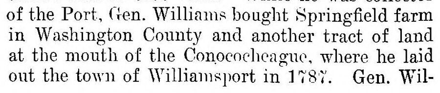
of the Port, Gen. Williams bought Springfield farm in Washington County and another tract of land at the mouth of the Conpcocheague, where he laid out the town of Williamsport in 1787. Gen. Wil-
Text read by machine from the scan; it may contain errors.
Scans and text from the Internet Archive. Books published in 1930 or earlier, which are in the public domain.
Timeline
Williamsport, 1796 to 1944
Woven from the archive, old maps, post office records, the National Register and the people born here.
Williamsport is among the most historic 1% of U.S. towns. The History grade combines the town’s founding era, the share of homes built before 1940 and its National Register listings. It’s a character grade, so it isn’t part of the overall grade. How it works.
What is on the National Register in Williamsport?
5 listings: 4 buildings, among them the Rose Hill (listed 1973, the first), and 1 historic district, the Williamsport Historic District, with 416 contributing buildings. 431 historic buildings in all.
How old are the homes in Williamsport?
32% of Williamsport’s homes were built before 1940 (Census estimate, ±2.2 points), against a typical 3.3% for a Maryland town; the median home was built in 1964.
Founding dates: Wikidata, Wikipedia, the U.S. post office records of Blevins & Helbock (CC0) and the Census. Homes by year built: Census ACS 2020–24. National Register of Historic Places: National Park Service (list of May 22, 2026). Old photos, postcards and papers: Wikimedia Commons, the Library of Congress and other public archives, credited on each item’s page. Maps: U.S. Geological Survey historical topographic maps (via Esri) and Sanborn fire-insurance maps (Library of Congress). History text and census tables: Wikipedia (CC BY-SA 4.0). Places that used to be: USGS Geographic Names Information System (2021).
From Wikimedia Commons (14), the Library of Congress (16), the National Register of Historic Places (5), Wikipedia, Wikidata and Wikipedia for famous people, U.S. Geological Survey historical maps, U.S. Census counts (via Wikipedia), the US Post Offices dataset (Blevins & Helbock), the USGS Geographic Names Information System, Sanborn fire insurance maps (Library of Congress) and old county and town histories (Internet Archive). Archive images are copied here with their credits and licenses, shown on each photo’s page. Refreshed monthly.


 1861
 1862
 1862
 1863
 1863
 1863
 1863
 1863
 1863
 1863
 c. 1875
 1892
 1892
 1897
 1900
 1900
 1900
 1903
 1904
 1904
 1906
 1906
 1906
 1917
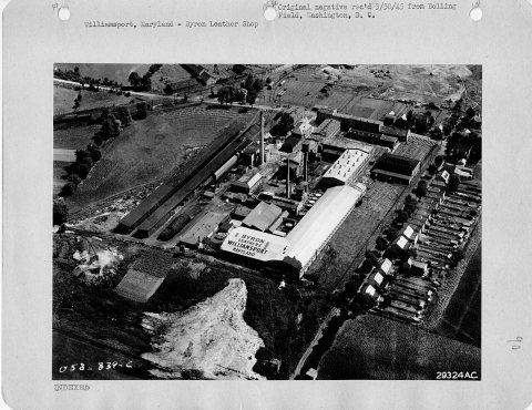 1917
 1917
 1917
 1933
 1933
 1933