Odenton dates to 1868, and 3 of its places are on the National Register
More historic than 30% of U.S. towns · #143 of 261 in Maryland. What drives it
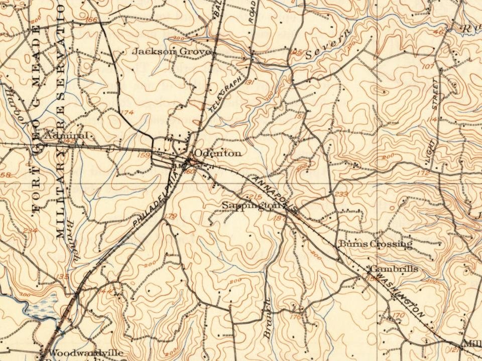
Most of Odenton was built recently: 2% of its homes predate 1940 and the median home dates from 1999. Its Register listings are the Epiphany Chapel and Church House, the Citizens State Bank and the Odenton Masonic Lodge No. 209. Below: maps from 1894 on and the census since 2000.
Founding year: Wikidata. First post office: 1869.The full story ↓
History grade
What drives Odenton’s History grade
On its age, its old homes and the National Register, Odenton is more historic than 30% of U.S. towns, #143 of 261 in Maryland. Its National Register listings hold the grade up; its share of homes from before 1940 pulls it down.
C
HistoryA character grade: shown, never part of Odenton’s overall grade.
Few Maryland towns list much on the Register (a typical Maryland town has 0.9 per 10,000 residents, the U.S. 2.4), so Odenton’s 0.7 sits near the middle of its state (44% of Maryland towns have fewer) while its 3 listings outnumber those of 65% of U.S. towns.
How sure. Graded on any two of the three inputs instead, the letter would range from C− to C+. The pre-1940 share (±1.3 points) is firm at this size. Two sources give 1868.
Founding year: Wikidata (other dates in Quick answers). Homes: Census ACS 2020–24. National Register: National Park Service, May 2026 list; each listing counted once (boundary changes and added documentation belong to their listing), and a historic district counts its contributing buildings. How TownRatings grades history →
What stands out about Odenton’s past
Read from the archive, the National Register and the record. The page puts what stands out first.
Lost post offices, old corners, places now gone and burying grounds
Odenton’s post office has been open since 1871. Two other post offices opened and closed inside today’s town.
Sappington
1869–1885
Odenton
1871–today
Gambrills
1885–today
Jackson Grove
1885–1889
18601940today
Hamlets and corners on the map
Academy JunctionAndersons CornerArundel AcresArundel Mobile VillageArundel ViewBells Mobile Home ParkBonaventureChapelgateColony RidgeFour Seasons EstatesGambrillsHammond ParkHidden VillageJackson GroveKings HeightsKings RansomLions GateMaple RidgeMayfieldMeadedaleMillersville ForestMistwoodOdenton HeightsOdenton Park
In 1840, the steam-powered Annapolis and Elk Ridge Railroad (A&ER) was built across a sparsely settled farming community that would later become Odenton. At the beginning of the Civil War, Union soldiers guarded this railroad line because it was the only link between the North and the nation's capital. Rail traffic through Baltimore had been disrupted by southern sympathizers, so supplies, mail and soldiers flowed through Annapolis and west Anne Arundel County to Washington.
Passages that mention Odenton, cut from the printed page as they were published.
A history of Anne Arundel County in Maryland1905Read the page →
Read the text
8. Odenton is a village of two hundred inhabitants lying in tlie Fourth Election District of Anne Aiundel, fourteen miles northwest of Annapolis, at the intersection of the Baltimore and Potomac and the Annapolis, Washington and Baltimore Eailroads. Its origin was due to the building of the Baltimore and Potomac Kailroad and its intersection with the Annapolis, Washington and Baltimore Koad. The new station on the Potomac Eoad was named Odenton after Governor Oden Bowie, then the president of the Potomac Kailroad. Mr. Peter Watts who owned the land through which the railroad passed, built the first house in the new town, and opened
Text read by machine from the scan; it may contain errors.
Scans and text from the Internet Archive. Books published in 1930 or earlier, which are in the public domain.
Timeline
Odenton, 1868 to 1894
Woven from the archive, old maps, post office records, the National Register and the people born here.
In 1868, according to Wikidata. Odenton’s post office opened in 1869, and the census of 2000 counted 20,534 people here.
How does Odenton rank for history?
Odenton is more historic than 30% of U.S. towns, #143 of 261 in Maryland. The History grade combines the town’s founding era, the share of homes built before 1940 and its National Register listings. It’s a character grade, so it isn’t part of the overall grade. How it works.
What is on the National Register in Odenton?
Three places: the Epiphany Chapel and Church House (listed 2001), the Citizens State Bank (2013) and the Odenton Masonic Lodge No. 209 (2022).
How old are the homes in Odenton?
2% of Odenton’s homes were built before 1940 (Census estimate, ±1.3 points), against a typical 3.3% for a Maryland town; the median home was built in 1999.
Founding dates: Wikidata, Wikipedia, the U.S. post office records of Blevins & Helbock (CC0) and the Census. Homes by year built: Census ACS 2020–24. National Register of Historic Places: National Park Service (list of May 22, 2026). Old photos, postcards and papers: Wikimedia Commons, the Library of Congress and other public archives, credited on each item’s page. Maps: U.S. Geological Survey historical topographic maps (via Esri) and Sanborn fire-insurance maps (Library of Congress). History text and census tables: Wikipedia (CC BY-SA 4.0). Places that used to be: USGS Geographic Names Information System (2021).
From the National Register of Historic Places (3), Wikipedia, U.S. Geological Survey historical maps, U.S. Census counts (via Wikipedia), the US Post Offices dataset (Blevins & Helbock), the USGS Geographic Names Information System and old county and town histories (Internet Archive). Archive images are copied here with their credits and licenses, shown on each photo’s page. Refreshed monthly.