Founding year: Wikipedia. First post office: 1776.The full story ↓
History grade
What drives Elkton’s History grade
On its age, its old homes and the National Register, Elkton is more historic than 60% of U.S. towns, #64 of 261 in Maryland. Its National Register listings hold the grade up; its share of homes from before 1940 pulls it down.
B
HistoryA character grade: shown, never part of Elkton’s overall grade.
Few Maryland towns list much on the Register (a typical Maryland town has 0.9 per 10,000 residents, the U.S. 2.4), so Elkton’s 2.5 sits near the middle of its state (56% of Maryland towns have fewer) while its 4 listings outnumber those of 68% of U.S. towns.
NoteThe founding year comes from Wikipedia alone; no second source gives 1694.
How sure. Graded on two of the three inputs, so a change in either one moves the letter more than it would with three. The pre-1940 share is a Census survey estimate (±4.2 points).
Founding year: Wikipedia (other dates in Quick answers). Homes: Census ACS 2020–24. National Register: National Park Service, May 2026 list; each listing counted once (boundary changes and added documentation belong to their listing), and a historic district counts its contributing buildings. How TownRatings grades history →
What stands out about Elkton’s past
Read from the archive, the National Register and the record. The page puts what stands out first.
Lost post offices, old corners, places now gone and burying grounds
Elkton’s post office has been open since 1790. Another post office, Head Of Elk, opened and closed inside today’s town.
Head Of Elk
1776–1790
Elkton
1790–today
17701900today
Hamlets and corners on the map
Buckhill FarmsDelancy VillageElkton HeightsElkton LandingGilpin ManorHeritage ValleyHeritage WoodsHollingsworth ManorLittle ElktonNormira HeightsThe Meadows at Elk CreekTurn QuistWashington WoodsWhite HallWindsor Village
Gone or out of use
Elkton AcademyschoolElkton Colored SchoolschoolElkton Elementary SchoolschoolGeorge Washington Carver SchoolschoolHickory Run SchoolschoolHoward Street Public Schoolschool
1cemetery inside Elkton
Elkton
US Post Offices dataset (Blevins & Helbock, CC0). Places and cemeteries from the USGS Geographic Names Information System (2021).
Timeline
Elkton, 1694 to 1939
Woven from the archive, old maps, post office records, the National Register and the people born here.
Fire insurance maps drew every building, what it was made of and what it was used for, so insurers could price the risk of fire. Pick a year, then a sheet.
The town was founded by Swedish mariners and fishermen from Fort Casimir who settled the area in 1694. They called their settlement Head of Elk, as it was the head of navigation of the Elk River.
Passages that mention Elkton, cut from the printed page as they were published.
History of Cecil County, Maryland, and the early settlements around the head of Chesapeake Bay and on the Delaware River, with sketches of some of the old families of Cecil County1881 · page 349Read the page →
Read the text
quently ascertained. Clement Holliday and Nathaniel' Ramsay, commissioners appointed to take charge and dispose of confiscated property, laid out that part of the town of Elkton east of the Hollow, upon land before described as belonging to Robert Alexander, and in October, 1782, sold the building lots at public sale. Although the village of the Head of Elk had been in existence for many years before this time, it was quite small and consisted of only a few
Text read by machine from the scan; it may contain errors.
History of Cecil County, Maryland, and the early settlements around the head of Chesapeake Bay and on the Delaware River, with sketches of some of the old families of Cecil County1881 · page 457Read the page →
Read the text
After being rector of North Elk parish for three years, Mr. Duke, in 1796, resigned and went to Anne Arundel County, but returned to Elkton the next year, and soon afterwards removed to Kent County, where he taught a parochial school, but again returned to Elkton in 1799, and opened a school in Bow street, and during the next three years occasionally preached at North East, in his schoolroom at Elkton, and in the Episcopal church near the vil-
Text read by machine from the scan; it may contain errors.
Scans and text from the Internet Archive. Books published in 1930 or earlier, which are in the public domain.
By decade
Elkton, decade by decade
2 decades in the archive, from the 1770s to the 1900s. Scroll each row; tap a photo for its story.
Nothing in the archives for these yearsWeddings on Main Street, storms, parades, school pictures, the old store. If it’s in your family album, it belongs here.
In 1694, according to Wikipedia’s history of the town. Elkton’s post office opened in 1776, and the census of 1850 counted 1,099 people here.
How does Elkton rank for history?
Elkton is more historic than 60% of U.S. towns, #64 of 261 in Maryland. The History grade combines the town’s founding era, the share of homes built before 1940 and its National Register listings. It’s a character grade, so it isn’t part of the overall grade. How it works.
What is on the National Register in Elkton?
4 listings: 4 buildings, among them the Mitchell House (listed 1976, the first).
How old are the homes in Elkton?
11% of Elkton’s homes were built before 1940 (Census estimate, ±4.2 points), against a typical 3.3% for a Maryland town; the median home was built in 1988.
Founding dates: Wikidata, Wikipedia, the U.S. post office records of Blevins & Helbock (CC0) and the Census. Homes by year built: Census ACS 2020–24. National Register of Historic Places: National Park Service (list of May 22, 2026). Old photos, postcards and papers: Wikimedia Commons, the Library of Congress and other public archives, credited on each item’s page. Maps: U.S. Geological Survey historical topographic maps (via Esri) and Sanborn fire-insurance maps (Library of Congress). History text and census tables: Wikipedia (CC BY-SA 4.0). Places that used to be: USGS Geographic Names Information System (2021).
From Wikimedia Commons (18), the National Register of Historic Places (4), Wikipedia, Wikidata and Wikipedia for famous people, U.S. Geological Survey historical maps, U.S. Census counts (via Wikipedia), the US Post Offices dataset (Blevins & Helbock), the USGS Geographic Names Information System, Sanborn fire insurance maps (Library of Congress) and old county and town histories (Internet Archive). Archive images are copied here with their credits and licenses, shown on each photo’s page. Refreshed monthly.
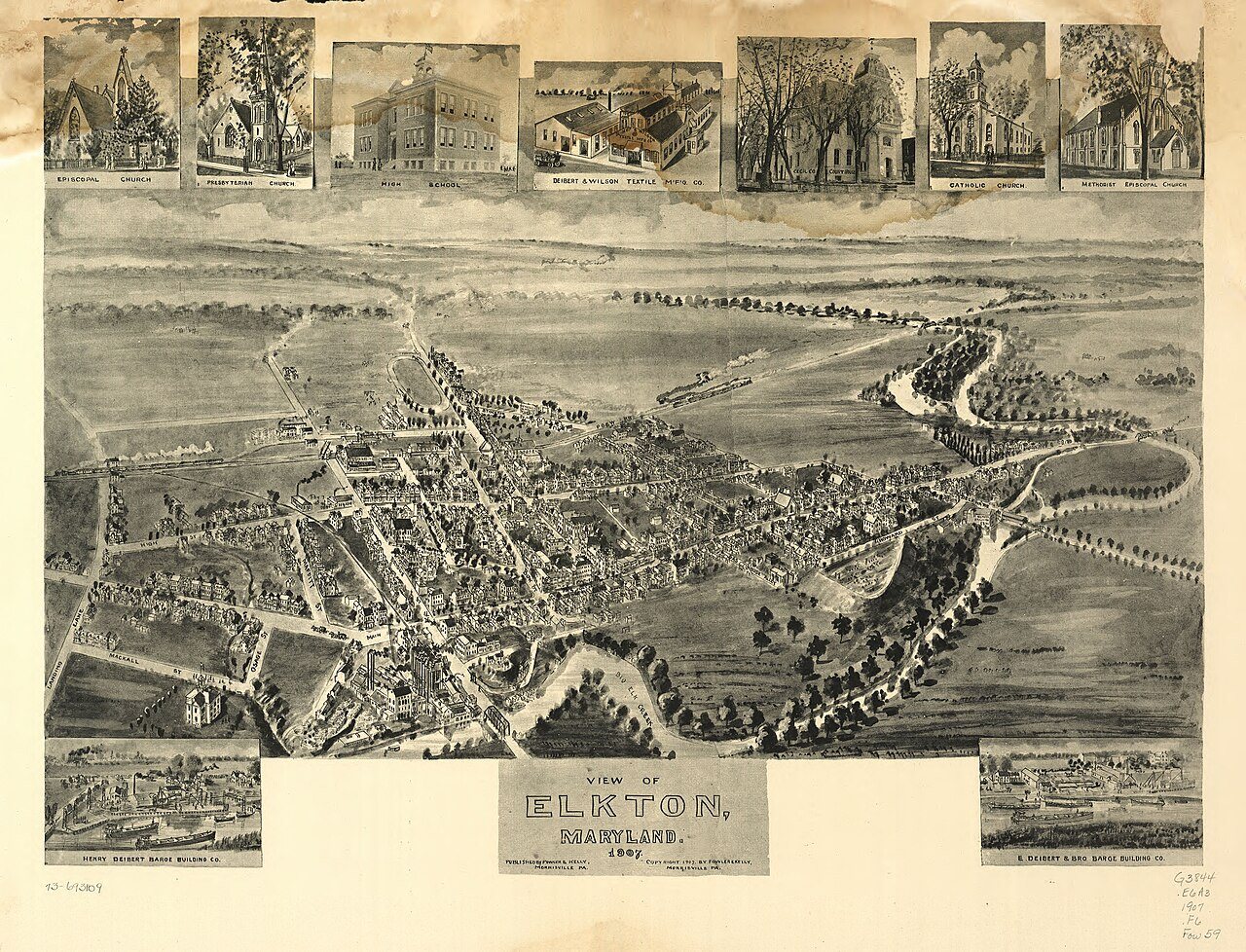




 1777
 1777
 1907
 1909
 1909
 1909
 1909
 1909
 1909
 1909
 1909
 1909
 1909
 1909
 1909
 1909


